


Extended Research


Extended Research
- Trending
- Comments
- Latest

Arya Resources is a newly formed (December 2022), Canadian-based junior exploration company trading under the symbol “RBZ” on the TSX Venture. With a focus on green energy, the company holds a diversified portfolio of highly prospective critical mineral projects in northern Saskatchewan, Canada. Focused on acquiring, exploring and developing prospective projects which include Nickel, Gold, Uranium, Lithium and Rare Earth elements in stable jurisdictions with the flagship property being the Dunlop Nickel Project

Introduction – A brief description of the company itself and general focus
Projects – A brief history and comprehensive break down of each project in Arya’s portfolio.
Conclusion – Summary of thoughts and most current activities.
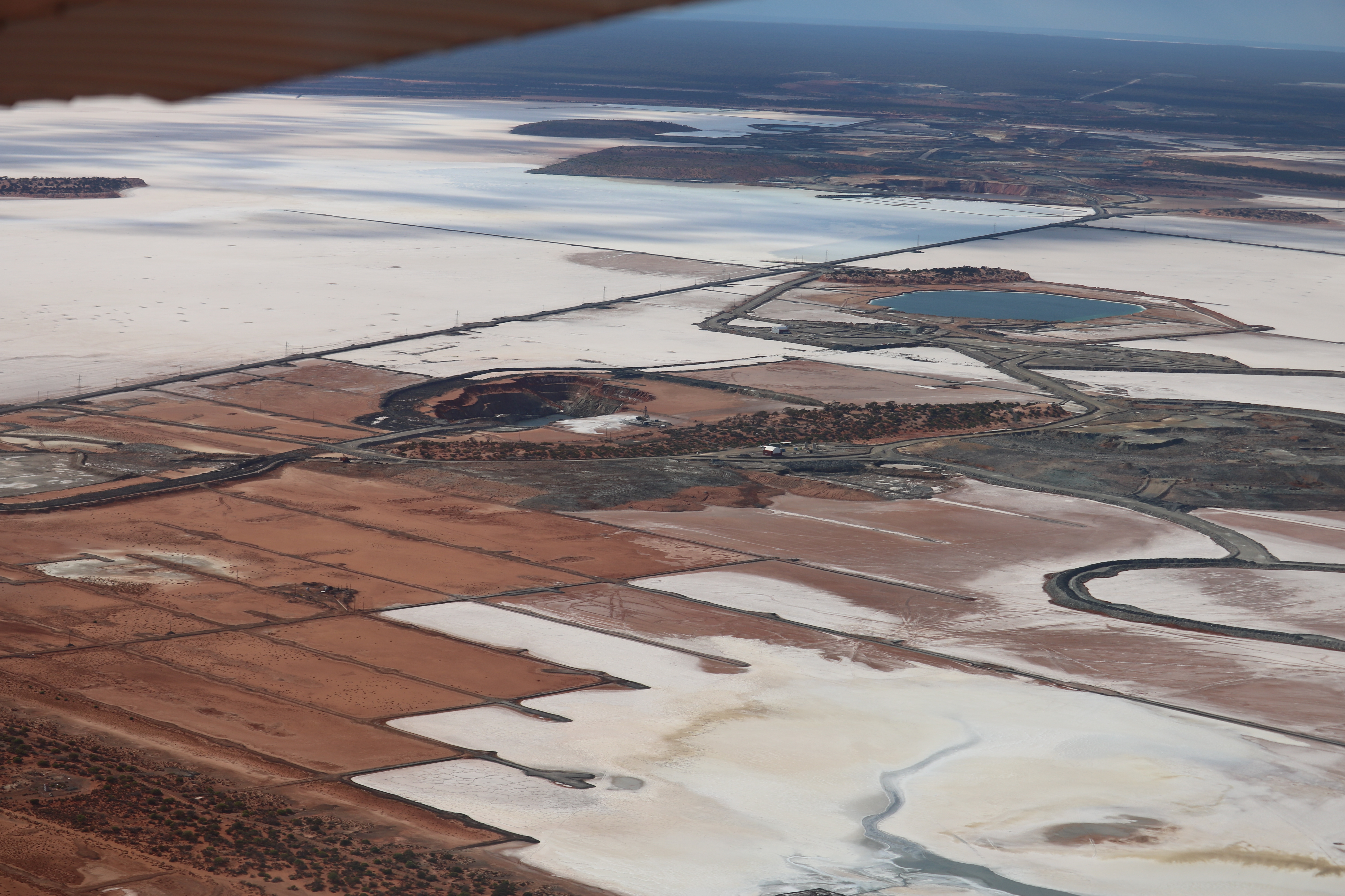
The Dunlop Nickel Project is the newest addition to the portfolio but it is the main focus as the flagship property. The project is located just 25 kilometres north of the town of La Ronge, along provincial highway 102, in northern Saskatchewan, Canada. Previous work on the property between 1960 and 1980 highlighted a deposit of 16.1 million tonnes of .34% Ni, and .18% Cu of which, 12.83 million tonnes were considered able to be mined as an open pit and the balance by underground mining and the grades ranged from 0.55 Ni – 1.46% Ni and 0.15% Cu – 0.39% Cu with assays of up to 0.35% Cr and 0.15% Co. (Source Reference: SMDI#0749 Saskatchewan Mineral Database Identification Number)
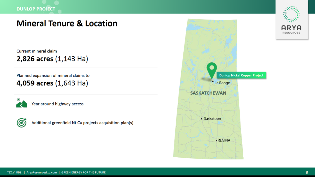
The Nemeiben Lake ultramafic pluton, which hosts the Dunlop deposit, is in the Churchill Province of the Canadian Shield in central Saskatchewan. The bedrock of the area is Precambrian, and is partly covered by Pleistocene glacial drift and recent bogs and lakes. Country rocks are composed of quartz Biotite schist and gneiss which have been intruded by a basic mass of pyroxenite and peridotite. The basic plug in which economic copper & nickel value occur, has been indicated by a Saskatchewan Government aero-magnetic survey and covers an area of approximately 4.5 square miles. within this 4.5 square kilometers there is a small 1.6 km circular plug largely composed of concentric layers of clinopyroxenite, websterite, and wehrlite with minor dunite and gabbro present in the northwestern reaches of the pluton. Disseminated primary magmatic pyrrhotite, pentlandite, chalcopyrite, magnetite, and chromite occur throughout the deposit and reach proportions of the northern outcrops.
A secondary assemblage, considered low-grade Ni-Cu of fine-grained oxides, sulphides, and native metals occurs in serpentinized and uralitized peridotites and pyroxenites but has yet to be followed up on.
Previous work has shown that nickel-copper mineralization, both disseminated and massive sulphides are present with at least three separate mineralized zones indicated on the property.
Chalcopyrite and nickeliferous pyrrhotite occur together in the surface showings and in drill core. The chalcopyrite occurs as disseminated grains and in small massive veins; whereas the nickeliferous pyrrhotite’ occurs in the peridotite and pyroxenite as a fine network of veins and stringers.
Other minerals found by previous work include nickel minerals; millerite, garnierite, and annabergite; copper minerals borrite, malachite, and native copper metal along with the minerals: chromlte, magnetite, epecularite, and marcasite. Additionally, it appears that no assaying for a full sweet of metals have been performed, which is interesting because gold, silver, platinum and other metals are known to run with basic nickel peridoties.

Updates will be added as they occur
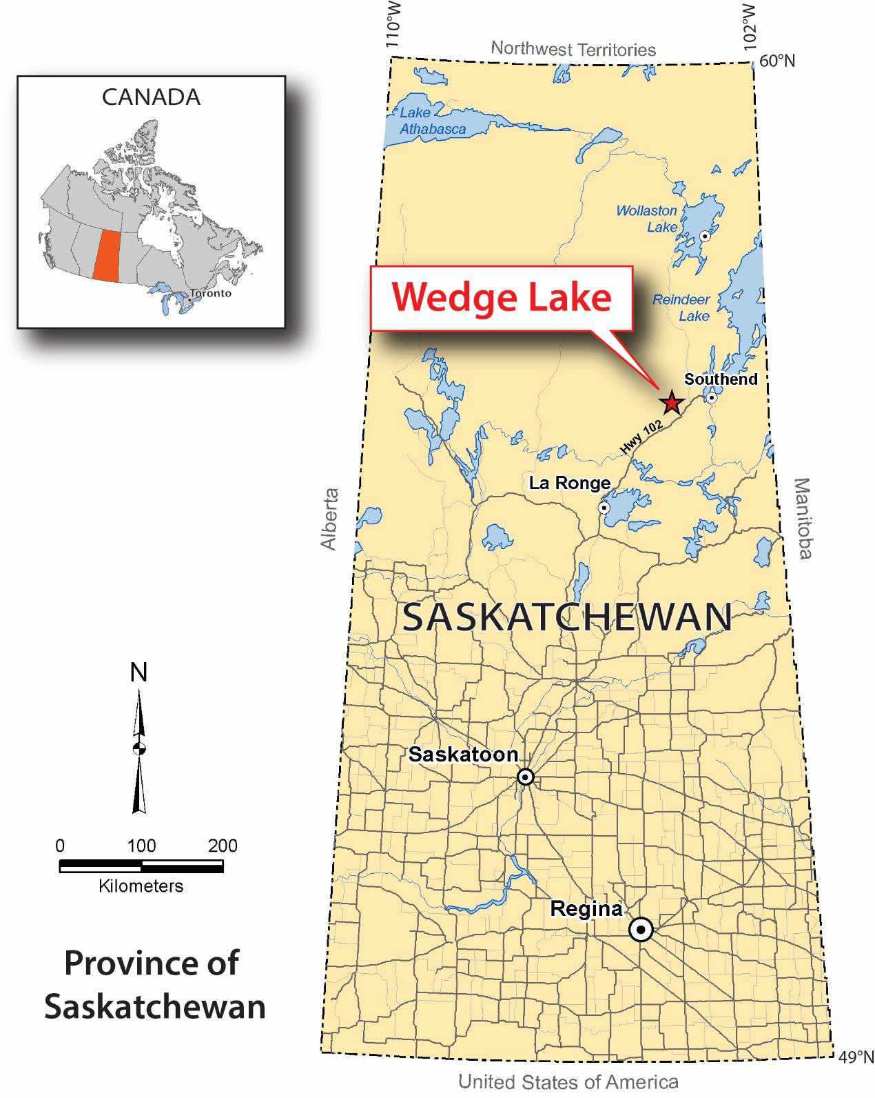
The Wedge Lake Gold Property is a 2,974 acre property which is also located in Northern Saskatchewan and is accessible by provincial highway 102, which brings you 171km north of La Ronge to Brabant Lake. There are three ways to access the property from Brabant Lake, the first is to travel along the Komis Mine Road to access Upper Waddy. The second being by boat from Upper Waddy Lake or the third via helicopter or fixed wing aircraft from La Ronge.
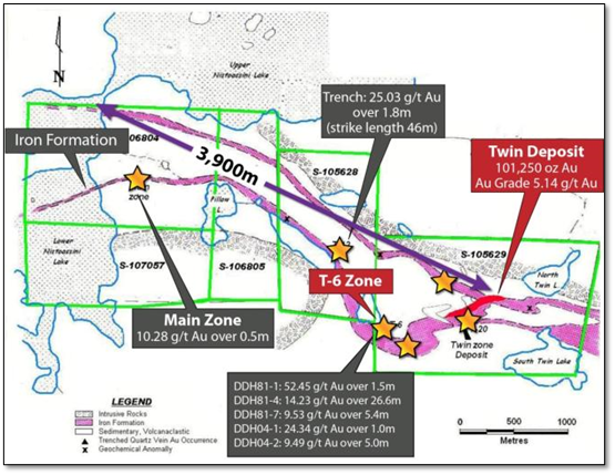
Mineral exploration on the Wedge Lake Property dates back to the 1920’s with sporadic stints of work being done on the property . The project features a historic non compliant resource of 101,250 Au ounces grading 5.15 g/t in an area dubbed the Twin Deposit but also has several additional high priority targets spanning 3,450 m along strike. Most notably, the T-6 Zone featuring 14.23 g/t Au over 26.6 metres.
Local resources can be found in La Ronge, located 172km southwest along highway 102 as it has services typical of a community of 2688 people but the town has limited access to trained mining personnel. Power is accessible via the power lines that run up the side of Provincial Highway 102 and water is plentiful with numerous lakes in the area.
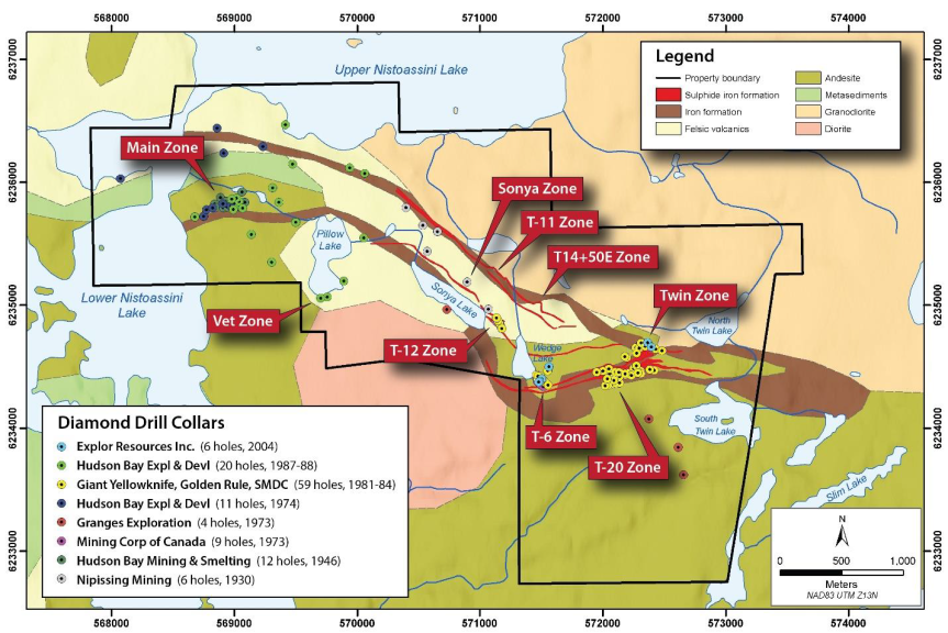
On a regional scale the Wedge Lake Property is located within the La Ronge domain which occupies the western portion of the Reindeer Zone of the Trans-Hudson Orogen in northern Saskatchewan. (Puritch et al., 2008). The Trans-Hudson Orogen is an Early Proterozoic (~1900 to 1780 Ma) orogenic belt that extends from South Dakota, through the exposed Canadian Shield in Saskatchewan and Manitoba to northern Quebec (Lucas et al., 1999) and arguably as far east as Greenland and Sweden (Lewry and Collerson, 1990).
On a local scale the Wedge Lake property is underlain by upper greenschist facies mafic to felsic volcanics and pyroclastics. Minor intercalated mafic tuffs and agglomerates are also present. The Nistoassini granodiorite batholith is located along the northern side of the project area while a diorite to quartz diorite stock intrudes the volcanic package to the west of Wedge Lake. A complexly folded package of laterally extensive mixed sulphide, oxide and silicate facies iron formation horizons are present within the felsic volcanic breccia. These iron formations are the target horizon for the gold exploration on the property.
Mineralization is widespread with several gold zones having been worked over the years on the Wedge Lake Property. There are 5 main zones on the property: Twin and T20, T6, T-12 and Main. The gold mineralization is associated with either the iron formation, or quartz veins within shear zones in close proximity to the iron formations.
On the Waddy Lake property, the most significant gold mineralization is within the volcanic package associated with quartz veining. The main modes of mineralization are summarized as follows (Netolitzky, 1980):
The 5 main gold zones are summarized as follows:
Twin Zone: The Twin Zone gold mineralization is exclusively stratabound and stratiform to sulphide facies iron formation – quartz-clast breccia unit. The quartz-breccia unit hosting the gold mineralization has been traced for 550m and varies in thickness from 5m to a maximum of 40m, with an average thickness of 15m (Frazer, 1993).
T-20 Zone: The T-20 trench is located between the Twin and T-6 zones. Here the quartz vein at the trench is conformable with the enclosing pillowed andesite flows and flow breccias. The vein has an east-northeast strike and a dip of -76° to the south. The quartz vein is weakly fractured and contains trace to 25% calcite, trace to 4% pyrite and trace pyrrhotite and has been intersected in 4 of 6 drillholes drilled at the showing. The zone has been traced over a strike length of approximately 95m.
T-6 Zone: Trench T-6 is located approximately 300m west of the Twin/T-20 zone and is characterized by gold mineralization hosted within quartz veins. The gold mineralization can be traced over a strike length of approximately 65m, ranges in width from 1.0 to 20m and to a vertical depth of approximately 75m below surface. The gold mineralization has been intersected in previous holes such as H-1, H-2, and H3/4/7 (Allen, 1982) with one of these holes (H-4) being a target for the “Twinning” diamond drilling program proposed in this report.
Surface mapping at Trench 6 indicates that a portion of the quartz vein was emplaced in a shear or fault zone prior to intrusion of a’ late-stage basic dyke. Finely disseminated visible gold occurs in quartz veins and stringers marginal to and within the dyke wall rock.
T-12 Zone: Trench 12 contains a north-northwest striking, steeply south to vertically dipping quartz vein transecting the enclosing volcanic sequence at a strike of between 300 to 350°. At surface, the exposed vein varies from 0.75m to 2.5m wide. The vein structure was evaluated by 5 drill holes to a depth of 25m vertical and along strike for 95m. The vein was found to be intensely fractured and contained 10% to 50% inclusions of wall rock. Minor chlorite on fracture planes, 1% to 3% pyrrhotite, minor pyrite, and rare specks of chalcopyrite are present within the quartz vein (Allen, 1981). Although no significant assays were obtained from the quartz vein material in the five drill holes a detailed compilation of the historic drilling is proposed in this report and could identify additional targets to drill in future programs at this trench area.
Main Zone: The main zone was first explored in 1946 by Hudson Bay Exploration and Smelting Company Limited with a twelve holes diamond drilling program along with ground geophysics and surface mapping. The drill program was targeted to test the depth extent of the surface mineralization associated with a mineralized shear zone. The shear zone has a strike of north 75° east and is dipping at -80° to the north. The mineralized shear zone contains pyrite and pyrrhotite in varying amounts and has been traced on surface for 300m and has an average core length thickness of approximately 40m. Near massive sulphides that are chalcopyrite rich are locally present along the surface trace of the shear zone (Trench 6 and 7) (Cairns, 1946). The mineralization in hole H-01 drilled beneath trench 6 graded 2.79% Cu over a core length of 24.2 feet, please note this copper mineralization has not been verified and is considered historic information that is not 43-101 compliant.
– In 1928 the first bit of exploration in the region got underway when Nipissing Mines Ltd. staked the Nisto Claims on the south shore of Nistoassini lake and did trenching and 5000 feet of diamond drilling over an extensive but barren sulphide facies iron formation but by 1929, additional activity on the site led to the discovery of several Cu/Au occurrences.
– In Late 1930’s and early 1940’s, Cominco Prospected a large area covering the La-Ronge – Reindeer greenstone belt and made several new discoveries of Au occurrences.
– In 1949, A.R. Byers of DMR performed Geological mapping at 1” to 1 mile ratio of the Waddy Lake
– In 1951 Mining Corporation of Canada Limited did a series of channel sampling of trenches.
highlights include
In 1953, The Mining Corporation of Canada Limited did limited diamond drilling but with only 1 favourable result yeilding 1.53 oz/ton over 5 ft core length. At the time when some big discoveries were being made these results were not considered significant, and the property was allowed to lapse.
– In 1964, GSC flew an Airborne magnetics survey of Waddy Lake were completed and mapswere published at 1:63360 (GSC maps 2840G and 2842G).
– In 1974, Hudson Bay Minerals did some diamond drilling on the Churchill Minerals Cu/Au showing at Upper Nistoassini Lake.
– In 1976, The Saskatchewan Geological Survey did geological mapping (SGS Report No. 220) and SGS Misc. report No. 84.4.
– In 1979 Bonn Energy Corporation Staked the Wedge Lake and Greenhill Lake Occurrences.
– In 1980, Golden Rule Resources Ltd./ Giant Yellowknife Mines had the claims transferred from Bonn Energy Corporation to Golden Rule effective January 7th, 1980. Golden Rule and Giant Yellowknife Mines then formed a 50/50 joint venture to which giant operator at the time, SMDC had the option to participate in the JV and do so. Following the transaction, Taiga Consultants were hired to do; line cutting, mag, VLF-EM, soil geochemical sampling, geological mapping and trenching at # 6, 11, 12 and 20 is performed.
– In 1981, Giant Yellowknife Mines did a 1500m Drill program, Infill mag., VLF-EM, soil geochemical surveys and additional detailed mapping, sampling and prospecting of property was completed.
– In 1982, Giant Yellowknife Mines performed a high sensitivity aeromagnetic survey over entire area flown by Geoterrex. In Addition, line cutting, ground mag, VLF-EM, trenching, sluicing, sampling of trench areas and prospecting along EM conductors was completed, with a follow up fall drill program of 1346.5 metres.
– In 1983, Giant Yellowknife Mines launched a 2 phased drill program of 16 holes totalling 2,346 metres and 1,140 re-check assays of previous drill core were performed and 81 polished thin sections were analyzed.
– In 1984, Giant Yellowknife Mines hired Taiga to complete additional exploration work including line cutting, trenching, core re-logging, Basal till sampling program, bore hole collar locations surveyed and metallurgical bench tests completed by Lakefield Research.
– Also in 1984, Giant Yellowknife Mines D.W.T. Lewis published a summary report on Twin Lake Gold occurrence with a geologically inferred reserve of 495,780 tonnes grading 0.16 opt Au.
– In 1987, Giant Yellowknife Mines – Taiga compiles exploration history report for Wedge Lake property.
– In 1992, Golden Rule Resources takes over operations of the joint venture.
– From 1999-2003, Petro Plus, Northern Star Resources and ODAAT did some Geophysical and geochemical work in the area.
– In 2004, Explor Resources Inc. drilled 6 holes for a total of 632m. The campaign testes 4 holes in the T-6 area and 2 holes in the Northeastern portion of Twin Zone.
– In 2012, La Ronge Gold flew an Airborne Mag survey and DGPS logging of historic drill holes.
– In 2016 – 2018, North-Sask. Ventures Ltd. did Ground Magnetics and HLEM surveys
Now lets backtrack a bit here because North-Sask. Ventures Ltd. first began exploring the property in 2007 and continued up until they sold the property in late 2021. The work they did consisted of predominantly ground magnetics and HLEM surveys. The most recent program, a modern horizontal loop electromagnetic (HLEM) survey was completed by Patterson Geophysics between February 15 to the 18th, 2021 and consisted of 22.9 line km of surveying. The MAXMIN survey consisted of 5 frequencies (440, 1760, 7040, 14080 and 28160 Hz) with a coil separation of 100m. The purpose of that survey was to map structural features by inverting the MAXMIN data with EM1DFM (electromagnetic, one-dimensional models, frequency domain magnetic dipole transmitter and receivers) and define new conductors that warrant drill testing.
– In 2022, Rebel Capital Corp agreed to terms to acquire the Wedge lake gold property in a reverse merger transaction on December 15, 2022. Under the terms of the transaction, 15,100,000 common shares were issued for the acquisition of the Property and CAD 0.4 million in cash, less advances. 6,080,000 Common Shares were issued in the concurrent financing, 4,080,000 Common Shares were reserved for issuance for the Common Shares underlying warrants issued in the concurrent financing. The Company would then have 25,409,995 Common Shares issued and Outstanding. Effective December 15, 2022, the company changed their name to “Arya Resources Ltd.” and began trading under the symbol “RBZ” by the end of the year.
Moving forward there are plans to do a full data compilation and analysis on the property ahead of a prospecting campaign to map, sample and confirm drill hole locations of past exploration efforts.
Updates will be provided as they occur
The KLSW Uranium Project consists of 2 individual projects in KLSW and Haultain and encompasses 33, 762 acres of highly prospective Uranium rich ground. It is located immediately south of the present day edge of the Athabasca basin, which is 28 Kilometers southwest of the past producing Key Lake Mine and mill. The project is also along strike with the P-2 thrust fault which hosts the McArthur River Uranium Mine. This geological trend is home to more than 2 billion lbs of U3O8- and is possibly the extension of a controlling fault for Cameco’s nearby Key Lake deposits.
On the property there is an estimated 10,000+ ha with REE potential and shallow Uranium deposit potential as there are pegmatite showings recorded nearby. The KLSW and Haultain Claims are surrounded by Cameco Corporation to the South, Baseload Energy Corp to the Southwest and Fission 3.0 Corp.to the southeast. Beneficially for Arya, Baseload is planning to do some drilling in 2023, as does CanAlaska.
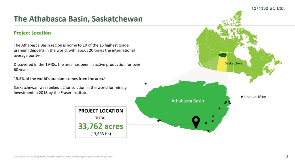
The Athabasca Group Basin covers approximately 100,000 square kilometres in northern Saskatchewan and northeastern Alberta. This area produces approximately 15% of the world’s primary uranium supply. The basin is made up primarily of unmetamorphosed sandstones, which were deposited on older metamorphosed Precambrian basement rocks. The break between the basement rocks and the overlying sandstones is called the “unconformity”. This is whwere very high grade deposits like Dielmann and Gaertner with up to 35% U3O8 and 20% Ni over 2 vertical metres, were discovered at the unconformity. Important to note though is that mineable ore also extends into the basement rocks 150 meters below the unconformity. An example of this would be the Millennium deposit with a measured and indicated resource of 53 million lbs with an average grade of 2.39% U3O8. The Denison Mines Corp. has found basement hosted uranium mineralization at 180 m below the unconformity in their Gryphon Zone on the Wheeler River project, approximately 4 km northwest of the Phoenix deposit.
Depth to the unconformity ranges from a few metres at the basins rim to 1500 metres at its centre. The Eagle Point mine and the Patterson Lake South discoveries were found outside but close to the margin of the Athabasca sandstones. The Eagle Point mine produced 4.1 million pounds U3O8 in 2013. At Patterson Lake, Nexgen Energy Ltd. Arrow deposit high grade uranium mineralization starts at 100 metres from surface and extends to 920 metres below the bedrock surface.
The Key Lake Southwest property is close to the present Athabasca Group margin. Regolith, which is alteration of upper metamorphosed basement rock unconformity, is present on the property. This suggests that the glacial erosion of basement rocks below the unconformity was not deep and that unconformity related uranium mineralization in the area could have been preserved.
*No significant uranium mineralization has been found to date on the property
This project got underway in 2008 when Majesta Resources Inc., the original owner, collected 180 lake water and lake sediment samples during a 2008 program and 699 soil samples during summer
– In 2009 the best results were announced with a maximum of 14.3 pCi/L radon in water samples, 54 ppm U and 27.6 pCi/L radium from lake sediment. In the soil sampling program the best results obtained were a maximum of 95.5 pCi/L radium and 40 ppm U.
– In 2010 Kirrin Resources Inc. (Kirrin) (KYM-TSX) completed two airborne magnetic and electromagnetic surveys and after a detailed interpretation by Condor Consulting Inc., they launched a prospecting program. Highlighted in the 2010 interpretation of the 1076 kilometres, Fugro Geoscience TEMPESTTM airborne EM and magnetometer survey data was a 78.2 kilometres of conductive trends with 19 target anomalies and 4 areas demonstrating a wide response due to
a surficial or flat-lying source.
– In 2011 interpretation of a 1615 km of Geotech Ltd. (Geotech) VTEMTM airborne survey data by Jagodits of Savaria Geophysical Inc. identified a marked change in magnetic patterns between the property’s western and eastern sections, correlating to the Mudjatik and Wollaston domain rocks. A northeast striking, linear magnetic high trend forms the western boundary of the Wollaston Domain. Conductance in 35 segments ranged from <5 to>25 siemens. A high priority rating was given to 37% of the conductors. Additionally, Radiometric prospecting traverses along four of the VTEM conductive trends failed to identify any significant anomalies.
– In 2013 Majesta did a boulder sampling program on the Thick Lake area and collected 191 composite sandstone samples. SRC Geo analytical Laboratory ICP analysis and clay alteration percentage calculations obtained results of up to 11.4 ppm As, 22 ppm Li, 2.0 ppm Mo, 34 ppm Th and 4.4 ppm U. Sixty-four radon determinations of lake water samples were also collected. 24.48 pCi/L at the northeast end of Thick Lake was the highest value obtained.
– April 2014, Majesta reported results of radon determinations on 264 lake-bottom water samples. Several clusters of readings over two times background were identified. Radon values reached 48.2 pCi/L. Grid line-cutting with total field magnetic and limited HLEM surveys were conducted on parts of the Thick Lake claim as well. May, 2014 Majesta ran radon determinations on a 211 sample helicopter assisted lake bottom water sampling program. Several areas with greater than twice background were identified associated with the 2010 airborne VTEM target zones.
– June, 2014 Geotech flew a potentially important, 254 line kilometres of VTEMTM airborne survey over the Thick Lake area of the KLSW property. Condor interpreted
the data which identified 108 deep source point anomalies and 41 wide source anomalies, which were grouped into 11 Target Zones. Each anomaly in every Condor target zone is rated as to their significance using geological and geochemical sampling results from the Thick Lake area.
– February 2023 – Arya acquires the property.
Updates will be provided as they occur
On February 7, 2023, The company announced the acquisition of 20,611 acres of Potential Lithium (Li) bearing Spodumene Pegmatite claims about 30 kms southeast of the Athabasca basin in Saskatchewan, Canada. Historical drill-hole data on property indicates the presence of Pink Pegmatites in several drill-hole intercepts. However, drill core was not sampled for Lithium, in the past.
The company is planning a field work program to map and sample the pegmatites for Lithium (Li) and other metals.
This section will be updated as progress is made on the property
Arya’s mission is to be part of a solution to the world’s increasing demand for energy metals. The vision is to create wealth through mineral discoveries using modern scientific exploration tools and techniques. The company’s management is well connected to the global mining industry and capital markets and recognize that there are limited opportunities in the market for exposure to nickel, which is why the Dunlop Nickel project will be the flagship project. Additionally, The Wedge Lake asset also offers investors exposure to gold which is currently sitting around $2,000 USD per ounce. As a multi asset company, Arya is poised to capitalize on emerging markets and in particular critical minerals like Nickel that are rising in demand do to the electrification movement happening today.
Disclosure
At the time of creation, Arya Resources is a client of Insidexploration Analytics Inc.
Disclaimer
Project Reports are under the Issuers editorial control and published on Insidexploration. Information contained in Project Reports may change over time and may differ from other sources. For more information, please reference www.deltaresources.ca for Corporate, Technical Information and Project Specifications for the latest public disclosures.
Further;
The information herein is meant for informational and entertainment purposes only and does not constitute a recommendation to buy or sell securities. While every effort is taken to ensure the accuracy of everything contained on this website, no warranty of same is expressed or implied. While we endeavor to keep the information up to date and correct, we make no representations or warranties of any kind, express or implied, about the completeness, accuracy, reliability, suitability or availability with respect to the website or the information, products, services, or related graphics contained on the website for any purpose. While every caution has been taken to provide readers with most accurate information, we recommend that you consult a registered investment professional in your jurisdiction before undertaking any investment in any asset whatsoever.
All Issuer content within this space is considered authored by the Company (Arya Resources) as an extension of their digital presence. All copyrights are retained by each respective creator(s).