


Extended Research


Extended Research
- Trending
- Comments
- Latest
Mining companies often overlook the fact that not everyone is a geologist, nor do they understand the terminology used to describe mining activities. After listening to some of the questions presented to RNC management of late and reading some of the concerns of the retail market on various social media trading platforms, it has become quite apparent that a large number of investors and potential investors of RNC Minerals don’t have a thorough understanding of the mine or the underlying geologic structures that resulted in the large amount of gold seen at Beta Hunt
I have attempted to explain portions of this material in the past on discussion forums but this will be an attempt to put together a single overview of the shear structures, the two main gold deposition methods that occurred, as well as the spatial relationship of the shears and faults to each other, and how they interact with the sediment layer and mine ramp system. With the updated resource estimates recently released, I am hopeful that this article will help retail in understanding the size and scale of the resource area in relation to the overall mine and help bring it into perspective.
Regional Geological Placement

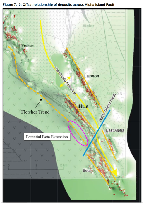
The Beta Hunt mine is located on the south-western edge of Kambalda which is part of the very prolific St.Ives Gold Camp and considered to be part of the Kambalda Domain. The Kambalda “dome” is a gently south plunging anticline, which extends 35 kilometres from the south end of Kambalda to the Junction Mine. In simpler terms, it is an upheaval of the sediments and lunnon basalt which result in the gold deposits being closer to surface. For this reason among a few others we will discuss, this has been home to many mines such as Mars, Redoubtable, Intrepid and Formidable which are all located above and along the same strike as the Beta Hunt mine. However, they all are predominantly located along the Belleisle Fault south of the Alpha Island Fault (AIF) yet so far, the main resources identified at Beta Hunt have mostly been found to the north of the AIF. Since the Belleisle fault (BLF) is one of the main feeders to BH, (I will explain why that is shortly) it goes to show the large potential still to come from the mine region south of the AIF.
It should be noted that the entire region is also part of a much older geological feature called the Kalgoorlie Terrane. This is a 6 to 9 km thick volcanogenic sedimentary sequence which is part of the Eastern Goldfields Province of the Yilgarn Craton and is the underlying proto-continent that created these structures in Western Australia. However, The Boulder Lefroy Fault Zone is ultimately considered to be the primary source of the gold fluid delivery system that feeds Beta Hunt. Reaching from the Kalgoorlie Gold Camp through the New Celebration Gold Camp and into the St. Ives Gold Camp, this is where it feeds the camp via a major second order structure known as the Playa shear which splays off the BLFZ and can be traced through the gold field for in excess of 10 kilometers. Most of the St Ives Gold Camp ore bodies mined to date are as a result of both of the Playa Shear and the Belleisle fault which are secondary shears that carry the gold-filled fluids to the AIF situated along the Kambalda Anticline.

“where do you look for a gold mine? Next to a gold mine”…or in our case under gold mines
Lunon Basalt and Sedimentary layers

“The Lunnon Basalt is an Archaean, subaqueous, tholeiitic metabasalt succession with thin ( <5m) interflow sedimentary rocks which has a minimum inferred thickness of 1750 m. It forms the oldest exposed stratigraphic unit at Kambalda.”
The lowest portion of the Beta Hunt mine is the oldest portion of the Terrane where the Lunnon Basalt was deposited in an ancient seabed in various flow stages.The mid-Atlantic ridge forming today would be a similar example. During the time period between flows there was an accumulation of sediment deposited which then would be covered by additional flows of the Lunnon Basalt. It’s important to note the sedimentary layer is a key control for the precipitation of the coarse gold as we will see in a later section, as the sediment contains a lot of iron as Fe which is part of the chemical reaction. So far there has just been the one sediment layer identified by RNC, but it is possible there were multiple, thin sediment layers deposited between any number of intermittent Lunnon Basalt flows. RNC makes mention of this potential on a bullet point on page 5 of the 9-11-2018 presentation “ potential for repeating sediment structures at depth.”
One last description of the Lunnon basalt from the 2016 PEA before we move on. “The footwall Lunnon Basalt is the lowermost unit in the stratigraphy at Hunt and is the host to the majority of gold mineralization. The Lunnon Basalt typically comprises in excess of a 1 km thickness of tholeiitic basaltic flows with persistent pillowed layers, flow top breccias and sediment bands. Composition-ally the Lunnon Basalt at Beta Hunt is similar to many of the other gold bearing mafic rocks of the Eastern Goldfields. Generally, the gold occurs in a broad steeply dipping north-northwest striking quartz vein system within sheared biotite-rich, pyritic basalt. There is typically intense albite, carbonate and chlorite alteration associated with the shear system.”
Gold Deposition
This graphic shows the relationship of the source of the gold fluids between the Boulder Lefroy Fault Zone and both the Playa and Belleisle faults.
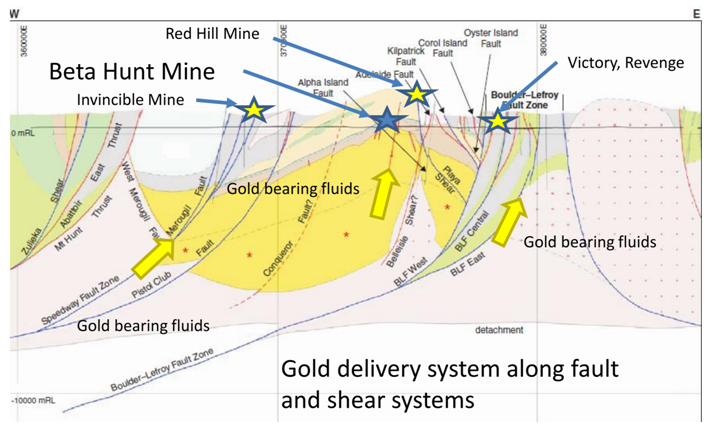
Several research and Doctoral papers have demonstrated that the secondary shears deliver gold filled hydrothermal fluids up to fill tertiary faults and their longitudinal cracks and fissures with the fluid under high pressure, filling and expanding the voids created in the rocks.
J. Hodges PhD dissertation (ref 1) provides the general concept that the gold filled hydrothermal fluids originate deep in the mantle under high pressure and then flow up through the pathways provided by the faults and shears “Both the New Celebration and St. Ives gold deposits show fluid inclusion evidence for methane within the hydrothermal fluid system, consistent with the development in an environment with a mantle connection.”
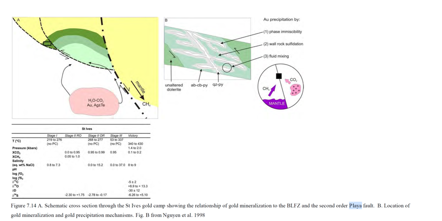

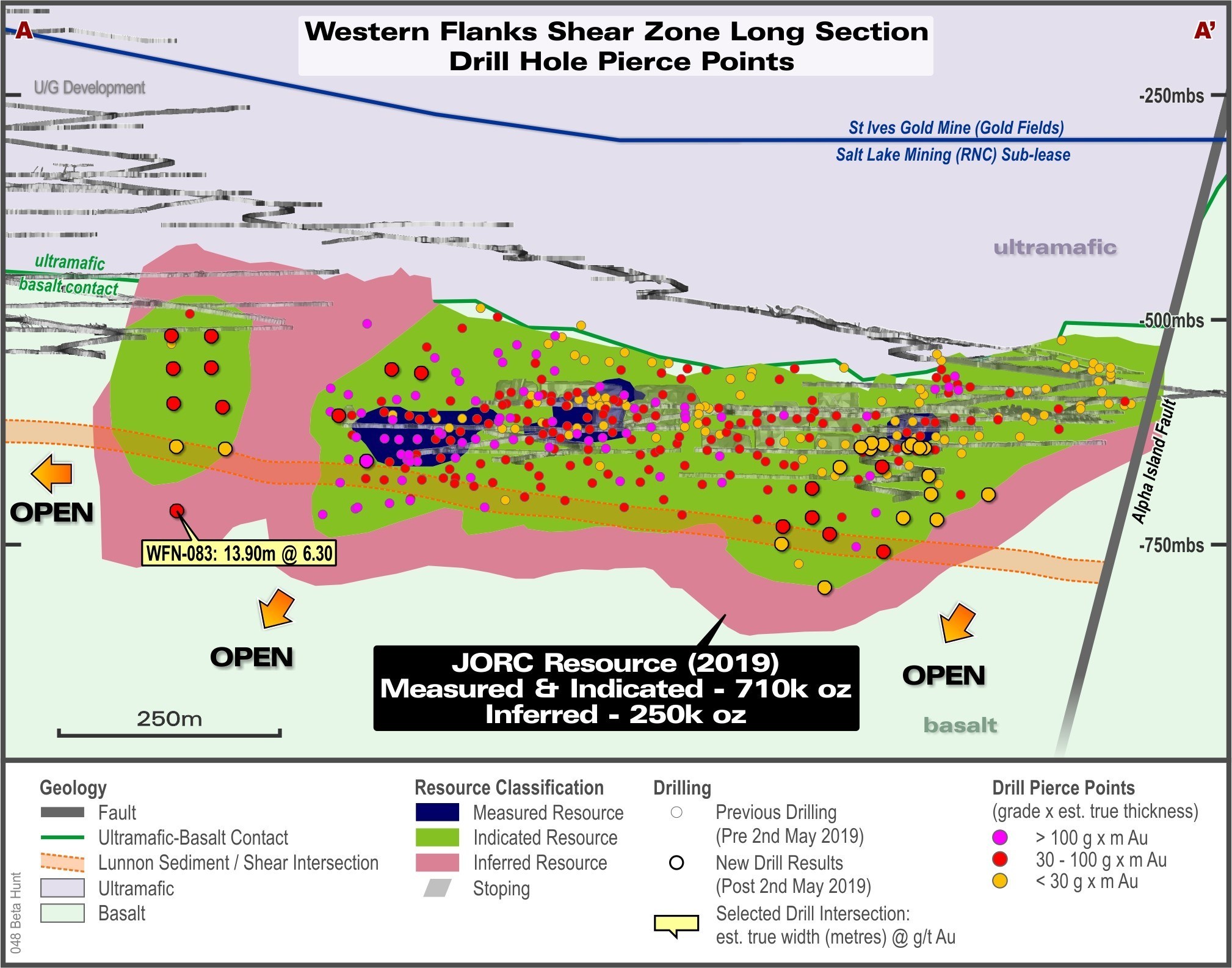
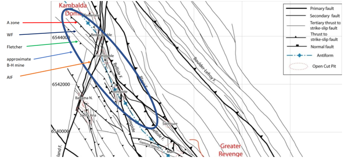
Past research has established both the source and the means of transport of the gold-filled fluids to the area surrounding the Beta Hunt mine, and in order to see the relationship of the mine to the various shears that feed it we are fortunate to have numerous fault and shear maps available. This one shows the additional 2nd order and 3rd order faults on the B-H mine property
Gold Deposition Methods
-Coarse Gold
-Bulk gold ore (flash deposition)
Before we move forward to the spatial relationship of the shears within the Beta Hunt mine, we should first briefly discuss the two main methods of gold deposition that occurred in the faults, shears and fissures at the mine. Each type occurs under different conditions and has resulted in both the pockets of high-grade coarse gold as well as the lower (but economical) grades of bulk ore in the shears themselves.
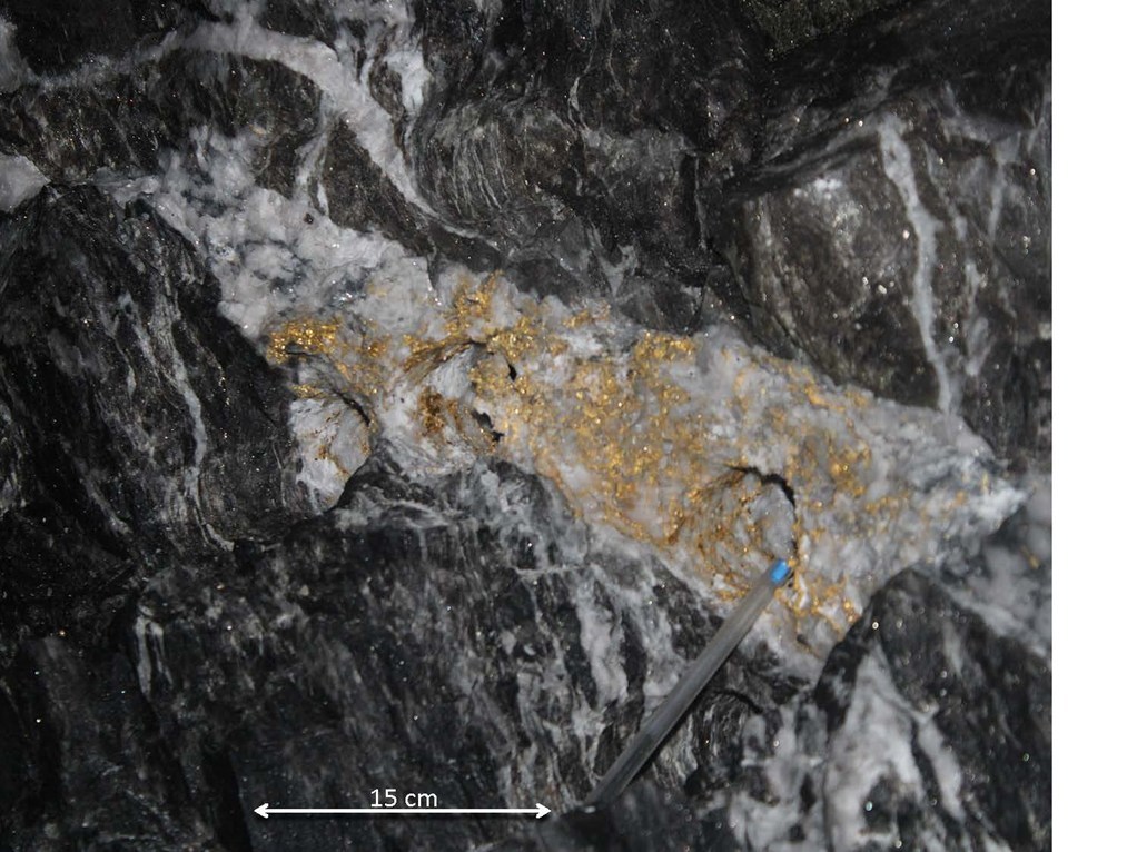
Coarse gold
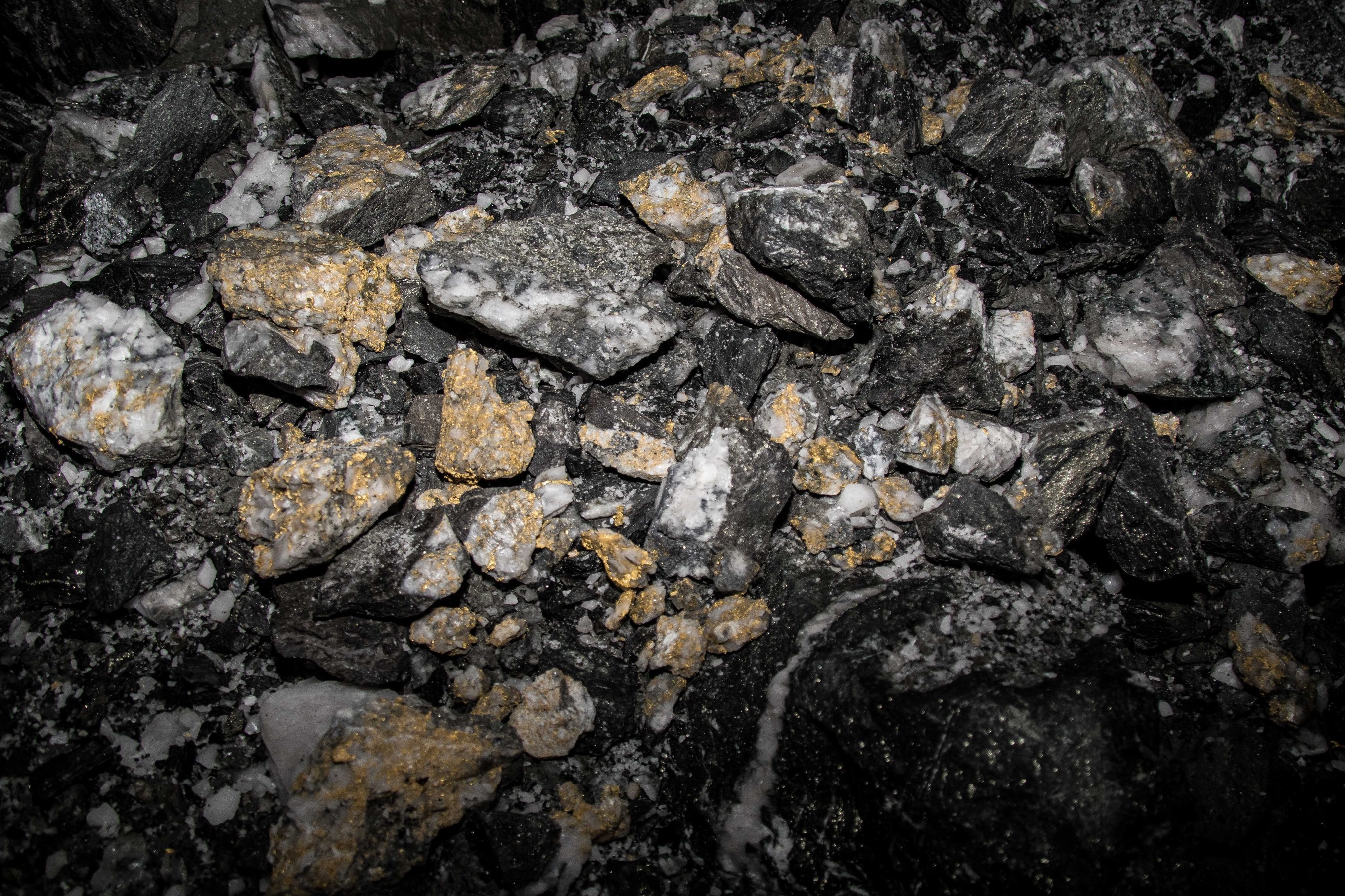
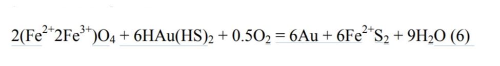
From ref. 5 we learn: “Most deposits, however, can be explained by a simplified model of fluid channel ways (veins, vein breccias, lithological contacts, shear zones) providing fluid access that allows fluid interaction with favorable (Fe-rich) host rocks (Groves et al 1984) This fluid-wall rock interaction results in important changes to the fluid, including gold solubility, and synchronous alteration of wall rocks (a major part of this study). The original composition of the wall rocks is critical to the type of interaction that occurs, and in particular, Fe-rich host rocks appear favorable for large gold deposits. Gold transport as reduced sulfur complexes of the form Au(HS), and deposition of gold
and pyrite by sulfidation reactions with the wall rocks are inferred to be essential processes in the generation of many Archcan gold deposits (Phillips and Groves, 1983).”
Note: for those interested in the specific chemical reactions taking place I have placed that information in the reference section at the end of this article.
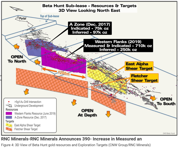
What they are telling us here is that iron rich rock causes a chemical reaction to take place that allows the gold content to precipitate out. The sediment layer interface is located between the upper and lower Lunnon basalt layers. This sediment layer is iron rich and it is the iron content contained within the sediment that caused the pockets of coarse gold to form. The sediment layer is relatively thin, less than 5 meters thick, so the coarse gold would be located primarily where the shears and faults intersect this sediment layer. The sediment layer covers or spans the entire Beta Hunt mine property as does the Lunnon basalt. However, due to the folding that occurred during the D3 and D4 deformations when the Kambalda Dome was formed this sediment layer is not simply lying flat across the property. Looking at this 3-D oblique view of the Beta Hunt property and the Kambalda Dome (below from the 2016 PEA fig 24.8) we can see areas of the mine where the sediment layer and basalt have been folded into a vertical orientation in some sections of the mine. What this does is create some locations where the shears and sediment layers don’t simply intersect at right angles, they actually make vertical, parallel contact for some distance which increases the total area of coarse gold deposit potential. This method of deposition is related to the formation of the pockets of high-grade coarse gold found in the region of the sediment layer and shear zone boundaries.
On some of the side views of the Western Flanks and A Zone that have been in news releases it appears to show the sediment layer as 80 meters or more thick. That is a matter of the orientation perspective, as noted above the sediment can be oriented vertically, similar to a blanket hanging from a ceiling…from the side view it may appear to be very thick as you look at the vertical orientation, but looking at that same blanket end on you can see it is in reality much thinner.
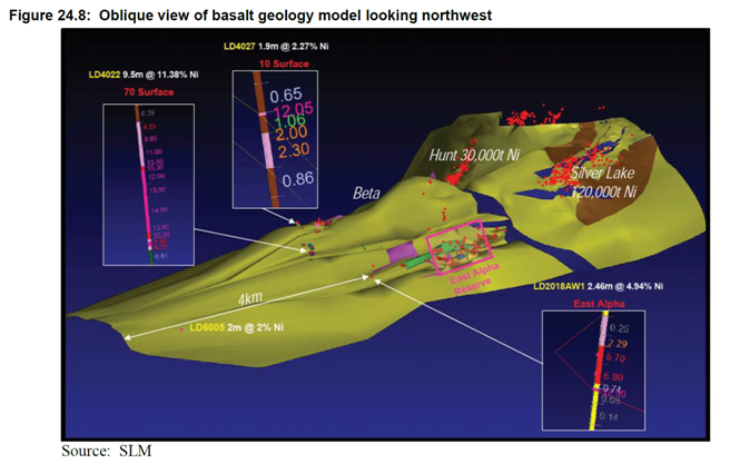
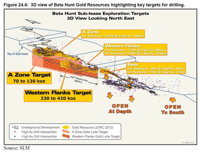
Looking at this view below of the B-H mine we can see the relationship of the anticline (the “spine” of the fold if you will) to the shears. The Western Flanks and A Zone (shown as Hunt on the view) has a large contact area with the down dip of the dome, leading to the vertical contact area of the shears and sediment in this area. Looking at the East Alpha a similar relationship exists, and while the East Alpha has primarily been only mined in the nickel lenses I suspect that when they perform further exploration drilling lower in the basalt and sediment area they will find additional gold deposits here as well, and in fact the new RE update does show that area below East Alpha as a gold target.
Flash Deposition
As the gold rich hydrothermal fluids rise up into the faults, shears and smaller fissures in the rocks (due to the pressure on the fluid exerted from below) they fill the cavities in the rock. This fluid is under very high pressure and relatively high temperatures (the fluids are at saturation temperature for the water content at that high pressure). The fluids are exerting pressure on the crevices to try to spread them out and whenever the rocks shift due to fault movement or more commonly due to even low magnitude earthquakes, the fluid pressure suddenly drops as low as 2 bars. This sudden drop in pressure means the temperature at that point is well above saturation temperature for the water content and it instantly flashes to vapor. At that point the solution is supersaturated and the gold and other minerals in the fluid flash mineralize in the small fissures and crevices in the rocks.
It only takes a slight amount of movement, as small as 2 or 3 cm to cause the sudden pressure release. But once the pressure drop has occurred, the high pressure fluid further down in the shear rises up to refill the voids created and re-pressurize the shear zone. Which leave behind stuctures like we see at Beta Hunt
Each event only deposits a small amount of gold, but over very long periods of time with a very large number of events the amount of gold and other minerals, primarily quartz, continue to build up and fill and expand the shears and adjoining rock fissures. It only takes a small earthquake on the order of magnitude 2 to cause the action to occur, and with aftershocks the number of events can be quite large in a seismically active region like the portion of W.A. that the B-H mine is located at.
From ref 4 this is how they describe this type of gold deposits, which are mainly in the portions of the mine that make up the bulk ore zones.
“We find that cavity expansion generates extreme reductions in pressure that cause the fluid that is trapped in the jog to expand to a very low-density vapour. Such flash vaporization of the fluid results in the rapid co-deposition of silica with a range of trace elements to form gold-enriched quartz veins. Flash vaporization continues as more fluid flows towards the newly expanded cavity, until the pressure in the cavity eventually recovers to ambient conditions. Multiple earthquakes progressively build economic-grade gold deposits.”
Edit: A reader had some confusion trying to separate the two different deposition types. I have a more detailed differentiation of the two posted in the end of the reference section.
Geometry/Spatial relation of mine with shears and sediment
To me, I think this is the part that most people find it hard to understand from the news releases. Unless you have really dug into the layout of the mine, looking at a single view or two in isolation in the release is hard to put in the proper perspective. This next section will be an attempt to piece the puzzle together to help it be more readily understandable
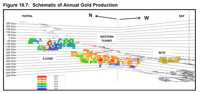
The first thing is the general shape of the mine. The mine has a lease ceiling due to the surface activity taking place, so from the portal at the North-east corner the lease area works its upper level lower and lower in a stair step fashion as we head south. Most of the decline portion of the mine is along the eastern half of the mine down to the alpha island fault. The A-Zone and WF working areas are north of the AIF and a bit higher elevation than the lower portion of the ramp system. The ramp continues lower to the south of AIF where it spreads out to the East Alpha and the Beta zones
So, when looking at the relationship between shears, we are not only looking at horizontal separation but also some vertical differences and to top it off a bit of an angled position.
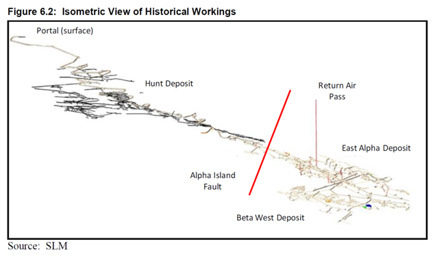
Here is a view of the mine taken from the 2016 PEA that shows the general layout of the mine zones and the ramp system (this is a good pre-updated RE view to use for comparison to the recent RE update release)
These next two views show the ramp system itself and the isometric relationship of the shear zones in the mine
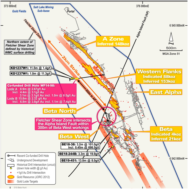
This plan view shows all the known resource areas ( from the 2016 PEA) as well as the prospective gold target areas. This view is looking down showing horizontal relationship but does not clearly show the vertical and offset relationship of the shear zones. Note that south of the Beta zone there are two gold prospective areas shown heading south. Those two zones should be part of the Belleisle shear and they do head further south about 3 km to the southern property boundary.
This view provides some perspective of the entire property size and how much unexplored area there is to the south.
So, then here we are, hopefully this article has helped put the structure of the mine together in a manner that helps visualize what the company has going for it and the potential yet ahead. I’ll leave you with a couple of screenshots from the recent RE Update that you can use with the information above to see what the team at Beta Hunt clearly sees.
Also, Thanks to @Barry4180, @flashbang45 and @Mikeymike426 for their help in providing much of the reference materials and our group discussions on the CEO.ca RNX DD channel that formed the basis of this understanding of the mine, the shear structure and their impact on the gold deposits.
References
(1) J.Hodges PhD paper https://www.pdfdrive.com/hydrothermal-evolution-of-two-stages-of-gold-
mineralization-at-the-orogenic-new-celebration-e60903547.html
(2) St.Ives http://www.goldfields.com/reports/ar_dec_2011/minerals/pdf/st_ives_mine.pdf
(3) Weinberg et. al
https://pdfs.semanticscholar.org/2c96/93934821cb24b73141d37a880f313a1b148e.pdf
(4) Flash Deposition https://www.nature.com/news/earthquakes-make-gold-veins-in-an-instant-1.12615
https://www.nature.com/articles/ngeo1759
(5) Coarse gold cdn.ceo.ca.s3-us-west-2.amazonaws.com/1e301gc-1e11171-neall1987.pdf
Coarse gold chemical reaction
An alternative reaction that causes gold to precipitate in the wall rocks is the carbonation of magnetite to form iron-bearing carbonates (Phillips et al., 1996) This results in significant fluid oxidation via the following reactions

These reactions destabilize the reduced gold bisulfide complexes and promote gold precipitation by the following reaction
Edit update with more distinction between the two different methods of gold deposition follows:
This is really two different mechanisms.
In the presence of Fe iron in the rock (in our B-H mine the Fe is contained in the sediment layer, but in some mines the iron could be part of the host rock as well) in the presence of iron a chemical reaction takes place if the gold bearing fluid is of the appropriate composition that the chemical process can transpire…and if you look at the final reaction I posted in the ref section of the article, there is a nice qty of gold that results.
But, this reaction does not require de-pressurization to take place. It is a purely chemical process.
The second method mentioned is indeed due to sudden depressurization. The gold bearing fluids are aqueous by nature, and when water is under higher pressure the temperature can be correspondingly higher without the water undergoing a phase change to vapor (steam). For instance, at about 2400 psi pressure water can exist in liquid form at close to 600 deg F (sorry, I have worked in those engineering units and don’t have the metric equivilents handy). but at atmospheric pressure (one bar) water undergoes the phase change to vapor at 212 deg F or 100 c.
The maximum temperature at which water can remain liquid at any given pressure is known as the saturation temperature. It is saturated with heat and cannot accept any more heat without changing phase. So, when the pressure is suddenly reduced, the temperature it is at is suddenly well over saturation temperature for that new, lower pressure and the water instantly vaporizes completely.
Now, if you have a solution of minerals and metals and you suddenly remove all the water portion of the solution, the remaining portions are super-saturated (confusing but similar term, any solution becomes super-saturated when you cannot add any more of a component into the solution without it precipitating out of solution)…so with the supersaturated condition the minerals and the gold precipitate out of solution… rapidly crystallize…but in this case it is more evenly disseminated and not as concentrated as the large amount of coarse gold that forms due to the chemical reaction with Fe.
So, the flash deposition method occurs regardless if the sediment layer is present or not.
Two methods, one requires the presence of Fe and happens with or without depressurization taking place.
The other happens due to the depressurization and does not require Fe to be present.
So, you can see that in the regions near the sediment both methods can and probably did transpire, forming large pockets of high grade concentrated coarse gold.
The regions in the shears not associated with the sediment layer would not likely undergo the chemical reaction unless there was some iron content in the host rock fissures. But the flash vaporization can and did take place through out the shear zones and nearby fissures and crevices and is the primary method for the lower grade bulk gold ore.
Disclosure: Author is long RNKLF at time of publishing and may buy or sell at any time without notice.
Disclaimer: The work included in this article is based on current events, technical charts, company news releases, and the author’s opinions. It may contain errors, and you shouldn’t make any investment decision based solely on what you read here. This publication contains forward-looking statements, including but not limited to comments regarding predictions and projections. Forward- looking statements address future events and conditions and therefore involve inherent risks and uncertainties. Actual results may differ materially from those currently anticipated in such statements. The views expressed in this article do not necessarily reflect the views of Insidexploration.com. This article is provided for informational and entertainment purposes only and is not a recommendation to buy or sell any security. Always thoroughly do your own due diligence and talk to a licensed investment adviser prior to making any investment decisions. Junior resource companies can easily lose 100% of their value so read company profiles on www.SEDAR.com for important risk disclosures. It’s your money and your responsibility.