


Extended Research


Extended Research
- Trending
- Comments
- Latest

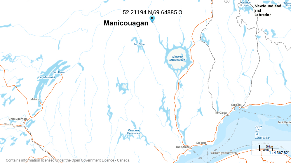
The Manicouagan Platinum-Palladium Project consists of 115 claims covering 61 km2 and is located approximately 70 km north of the Manicouagan Crater and 350 km northwest of the city of Baie-Comeau, in the province of Quebec. The property can be accessed via Camp Helene by air from either Baie-Comeau or Gagnonville’s paved airstrip. Gagnonville is situated just 100 kms ESE on provincial road 389 which runs between Labrador, Newfoundland and Baie-Comeau, Quebec.
The first geological reconnaissance mapping in the Manicouagan area was conducted by Low (1897) of the Geological Survey of Canada (GSC) at the end of the 19th Century. Then in 1968 the Manicouagan area was covered by national aeromagnetic surveys using a nominal line spacing of 800 meters. In 1987 the Quebec Ministry of Natural Resources (MRNQ) initiated a regional lake sediment survey which comprised of 1,200 individual samples and highlighted several multi element anomalies and favorable exploration targets.
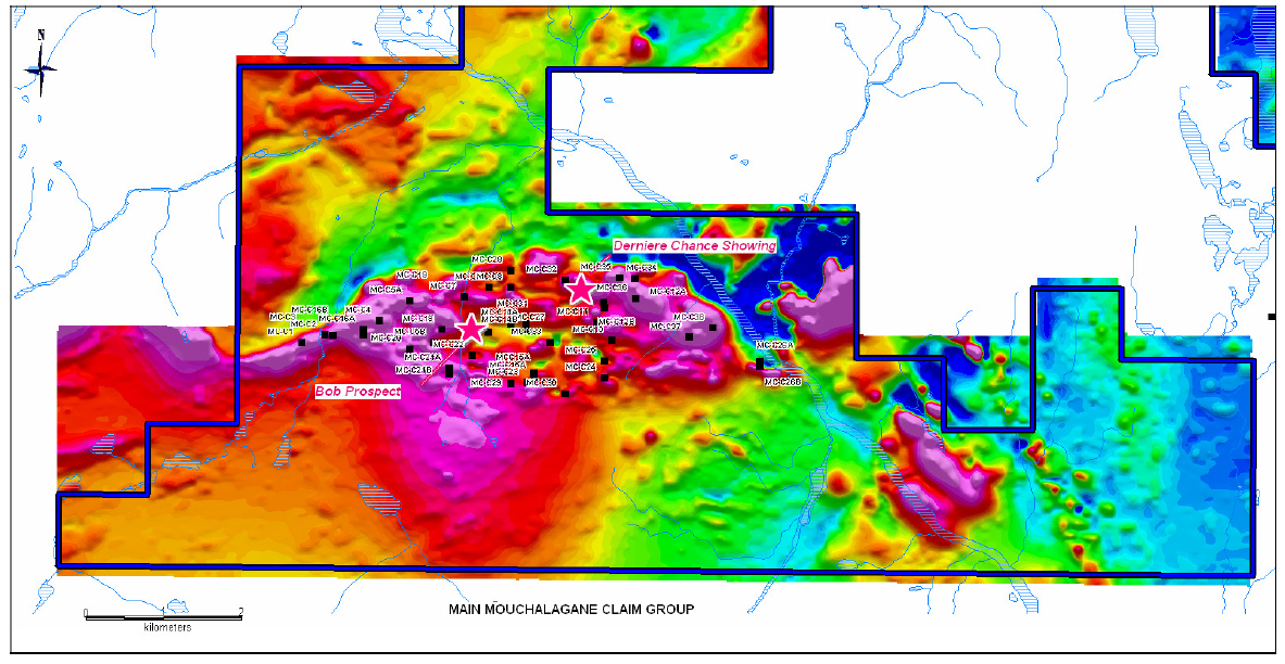
Then in 1997 the MRNQ mapped the lake Vallard area via ground traverses of 6-10 km lengths and 5-10 km spacing. This resulted in the discovery of the Mouchalagne Zone. The Mouchalagane Zone was described by Lamothe et al. as an east-west oriented gossan zone of 130m length and 25m width. It is enclosed within pillowed metabasalt in contact with a highly sheared, medium-grained, homogeneous metagabbro. The mineralization appears to be a meter-thick, and is located in the core of a fold nose.
The principal exploration targets on the property are for nickel, copper, and platinum group elements (platinum, palladium, rhodium and ruthenium) associated with reworked Archean ultramafic lithologies belonging to the Gagnon Terrane, which is part of the Grenville Geological Province.

The majority of work carried out to date was done by Manicouagan Minerals Inc. with a focus on the Main Mouchalagane Claim Group or property, except for the ground geophysical surveys carried out by Geosig in 2008 on the Western Mouchalagane Claim Group. There is no systematic structural analysis reported for the area but field evidence, such as the presence of cross-folds in a few localities, suggest at least two periods of deformation.
Polished section and detailed hand sample examination studies reveal that sulphides include disseminated and massive varieties and include fine grained recrystallized and coarse grained varieties. This aspect of the mineralization allows for the extraction of the various metals using our unique approach to extracting minerals with a greener approach.
In April 2006, Manicouagan Minerals Inc. optioned the Mouchalagane Property which at the time consisted of 58 map designated claims covering an approximate area of 30 km2. The company took interest when the previous owner made two discoveries; the “Dernière Chance” and one gold showing referred to as “Corbeau-2”. Nine grab samples were taken from the Dernière Chance showing which ranged from 0.30 to 3.51% Cu, 0.48 to 1.38% Ni, 0.94 to 2.12 g/t Pd and 0.12 to 0.82 g/t Pt. The Corbeau 2 Showing is located at approximately 100 meters northeast of the Dernière Chance Showing where one grab sample returned 2.74 g/t Au.

Also during the 2006 exploration program, a total of 395 soil samples were collected and 366 were assayed multi-elements Scan package in addition to a suite of rare earth elements, on the Main Mouchalagane grid area at a spacing of approximately 50 meters along the existing grid lines and at 25 meters around Bob and Bob-East Showings. This survey highlighted numerous and correlative anomalies in nickel, copper, cobalt and chromium suggestive of the presence of ultramafic rocks and are locally correlative with known Ni-Cu-PGE mineralization.
In 2007, ground magnetic and horizontal loop electromagnetic (“HLEM”) surveys were conducted by Geophysique TMC of Val-d’Or, Quebec, on the Main Mouchalagane Property. In total, 73.4 line-kilometers of magnetic survey and 62.6 line-kilometers of HLEM survey were performed. The 2007 survey also outlined various conductors on the property that form a large E-W oriented oval pattern about 5 km long by 1.5 km wide.
As a follow up, in 2008, Aeroquest international of Mississauga, Ontario flew their AeroTEM ll electromagnectic geophysical survey that covered 4,327 line kilometers and generated 788 AEM Anomalies. The Aeroquest data and maps were provided to Frank Jagodits a consultant geophysicist who reviewed, on a line by line basis and identified thirty-eight (38) prospective conductors on the Main Mouchalagane grid for the prospecting crews to ground truth before drilling.
Historical Drilling Programs
Two diamond drilling programs were carried out on the Mouchalagane Project in 2007/2008. The first program took place from July 20th to October 3rd, and consisted of thirty four (34) drill holes (MCH-07-01 to 34) totaling 2 957 meters. The second program took place between June 13th to July 6th, and was comprised of ten (10) holes totaling 1 770 meters. A total of 743 core samples representing a combined length of 475.4 meters were collected in 2007, and a total of 693 core samples representing a combined length of 449.7 meters were collected in 2008.
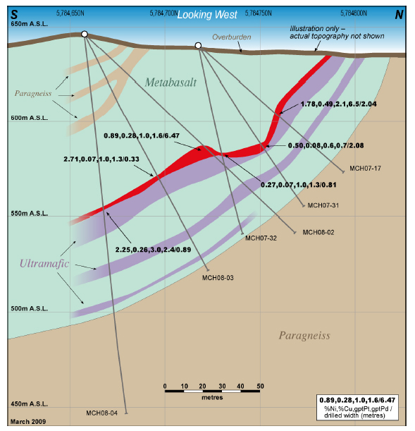
Bob Showing
The Bob Showing has been traced by drilling for a total strike length of approximately 200 meters over widths of up to 6.5 meters. It appears to be directly associated with two, east striking, weak, third priority, short strike length electromagnetic (HLEM) conductors. Of potential significance is the presence of a strong, first priority, east striking, 400 meters long EM conductor which is situated just 200 meters south of the Bob Showing which remains untested. The Bob-East Showing 45m away from the Bob Showing, returned outstanding assay results. Among the eighteen (18) holes drilled proximal to Bob and Bob-East Prospect, sixteen (16) holes intersected Ni-Cu-PGE mineralization for approximately 200 meters along strike and to a depth of about 90 meters. The mineralization remains partially open along strike and partially at depth.
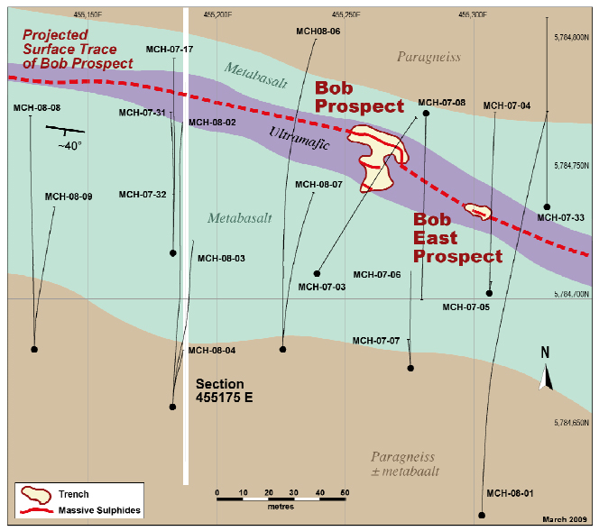
Highlights of drilling include
– Hole MCH-08- 08 intersected 1.48m grading 0.72% Ni, 0.22% Cu, 3.07 g/t Pd+Pt (0.50 g/t Pt and 2.57 g/t Pd).
– hole MCH-08-02 : 0.89% Ni, 0.28% Cu, 0.96 g/t Pt and 1.64 g/t Pd over 6.47 m; including 1.00% Ni, 0.36% Cu, 1.80 g/t Pt and 2.31 g/t Pd over 2.11 m
– Hole MCH-07-17 (between 51.40 and 54.44m) returned 1.78% Ni, 0.49% Cu, 914 ppm Co, 8.57 g/t Pd+Pt (2.11 g/t Pt + 6.47 g/t Pd), over 2.04 meters, including 3.82% Ni, 1.47% Cu, 0.21% Co, 23.40 g/t Pd+Pt (5.11 g/t Pt + 18.29 g/t Pd) over 0.57 meters. Note* This 2.04 meters section was re-assayed for the complete suite of PGE and returned 8.58 g/t Pd+Pt (2.11 g/t Pt + 6.47 g/t Pd), 0.44 g/t Rh, 0.40 g/t Ru.
-Hole MCH-07-13 2.30% Ni, 0.75% Cu, 800 ppm Co, 1.67 g/t Pd+Pt (0.71 g/t Pt + 0.96 g/t Pd) over 0.25 meters between 57.46m and 57.71
Additional highlights below
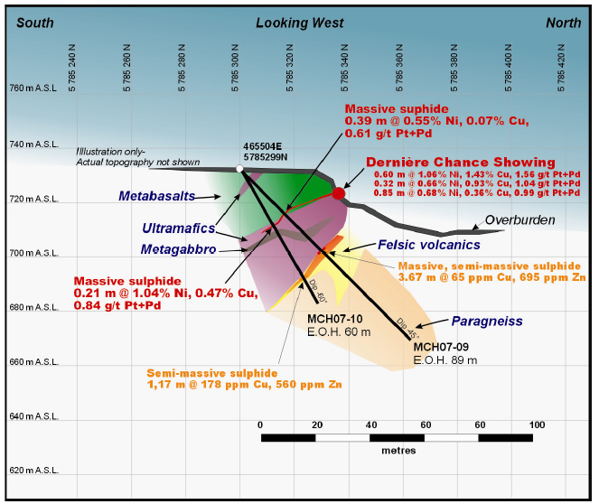
Derniere Chance
Ni-Cu-PGE mineralization at Dernière Chance is associated with an ultramafic unit at the interface with an overlying metabasalt. The host ultramafic unit was 19.67 meters in thickness in hole MCH-07-09 and was 22.29 meters thick in hole MCH-07-10. Mineralization in hole MCH-07-09 returned 0.55% Ni, 0.07% Cu, 0.61 g/t Pd+Pt over 0.39 meter. Hole MCH-07- 10 returned 1.04% Ni, 0.47% Cu, 940 ppm Co, 0.84 g/t Pd+Pt (0.20 g/t Pt + 0.64 g/t Pd) over 0.21 meters.
A volcanic felsic unit underlying the ultramafic unit was intersected over 14.4 meters in MCH-07-09 and over 4.1 meters in MCH-07-10. This felsic unit contains massive to semimassive sulphide mineralizations, which are anomalous in Zn and Cu (Figure 23). Semimassive to massive sulphide zones, consisting of pyrite and pyrrhotite, are interlayered at a scale of <40cm thickness over 3.67 meters in hole MCH-07-09, and returned 0.19% Zn over 0.81 meter. Mineralization in MCH-07-10 is predominantly semi-massive over 1.17 meter; assays returned 0.17% Zn over 0.21 meter.
Gold occurrences
Best surface gold results (sample 150501 : 2.81 g/t Au) came from Corbeau-2 showing area (Mouchalagane main grid). It confirms the previous grab sample that contained 2.74 g/t Au. Additionally, two (2) sulphide bearing felsic volcanics outcrops returned 1.2 and 1.1 g/t Au (samples 265904 and 150503). These occurrences are about 1 km apart, sample 265904 being located close to HLEM conductor D and sample 150503 being located right on HLEM conductor G.
Grab and Channel Sample Highlights
Bob and Bob-East showings:
Grab samples
Channel samples
Selected drill core samples from the Bob Ni-Cu-PGE Prospect that were analyzed for the complete suite of Platinum Group Elements (PGE) returned significant concentrations of rhodium (Rh) and ruthenium (Ru) in addition to the significant results :
Feu and Dernière Chance Showings :
Drilling at the Feu and Dernière Chance showing was successful in extending the known surface Ni-Cu-PGE mineralization to a depth of approximately 40 m.
The best channel sample
Mountain-Front Showing
A new occurrence of Ni-Cu-PGE mineralization was intersected in MCH-07-20 and 21 located about 600 m west of Dernière Chance and Feu, and may represent the long-strike extension of Dernière Chance and Feu Showings. .
The best intercept from the 2007 drilling was from hole MCH-07-20 which intersected 0.76 m grading 0.41% Ni, 0.16% Cu, 0.11 g/t Pt and 0.87 g/t Pd.
Consolidated Highlights
On January 27th, 2020 St-Georges Eco-Mining acquired 100 percent of the Manicouagan Nickel-Copper-PGE project. Then on August 13th, 2020 the company acquired two mineral claims from two arms-length vendors as the claims were land-locked within the other exploration licenses held by St-Georges. This completed the consolidation of the claims of interest to the company.
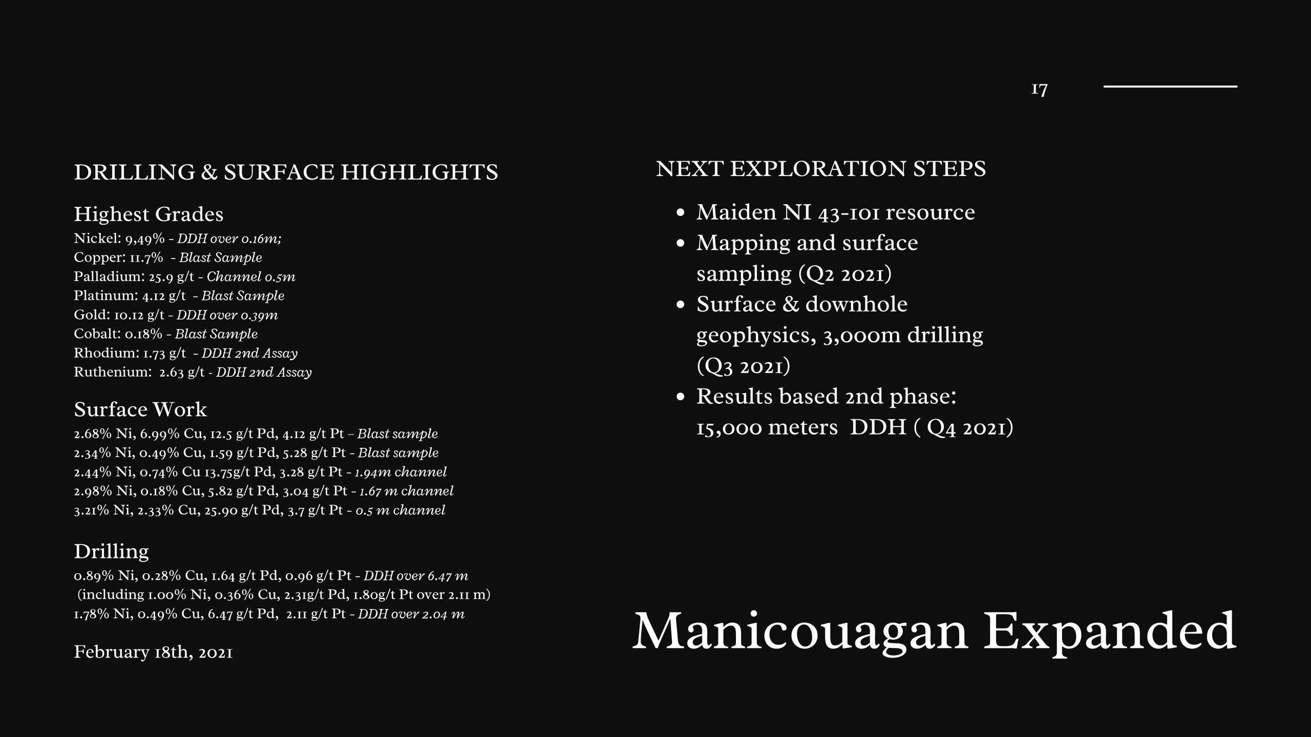
Exploration plan for 2021 The primary exploration target on the Manicouagan Project will be focused in extending and delineating new mineralized zones for platinum group metals (platinum-Pt, palladium-Pd, rhodium-Rh and ruthenium-Ru) enriched nickel, copper magmatic sulphide deposits. There is also potential to host volcanogenic massive sulphide, lode gold mineralization and/or epigenetic Cu-Ag (Au-Zn) mineralization which the company intends to investigate simultaneously. The company will conduct new geophysical surveys, detailed geological mapping and geochemical sampling to explore for a larger potential source. The company believes that this project is a complementary asset to the ongoing work at the Julie project.
Information within this document was sourced from
www.mrnfp.gouv.qc.ca/mines/index.jsp
https://sigeom.mines.gouv.qc.ca/signet/classes/I1108_afchCarteIntr
https://insidexploration.com/wp-content/uploads/2021/03/01-MCH2007-08-MRN-Report.pdf