


Extended Research


Extended Research
- Trending
- Comments
- Latest

Delta Resources Limited (TSXV: DLTA) is a well financed Canadian mineral exploration company focused on growing shareholder value through the exploration of two very high-potential gold and base-metal projects in Canada. The two projects currently being advanced are the Delta 1 Gold Project in Thunder Bay, Ontario and the Delta 2 Gold/VMS Project outside of Chibougamou, Quebec. Delta 1 is the company’s flagship project where Delta has been increasing its gold inventory with three phases of drilling since late 2022 when drill hole D1-22-18 returned 31 metres of 5.92 g/t gold. Since this discovery hole, Delta has drilled nearly 32,000 metres and outlined a mineralized zone over 2 kilometres long next to the Trans-Canada Highway.

Overview – General overview of the Delta 1
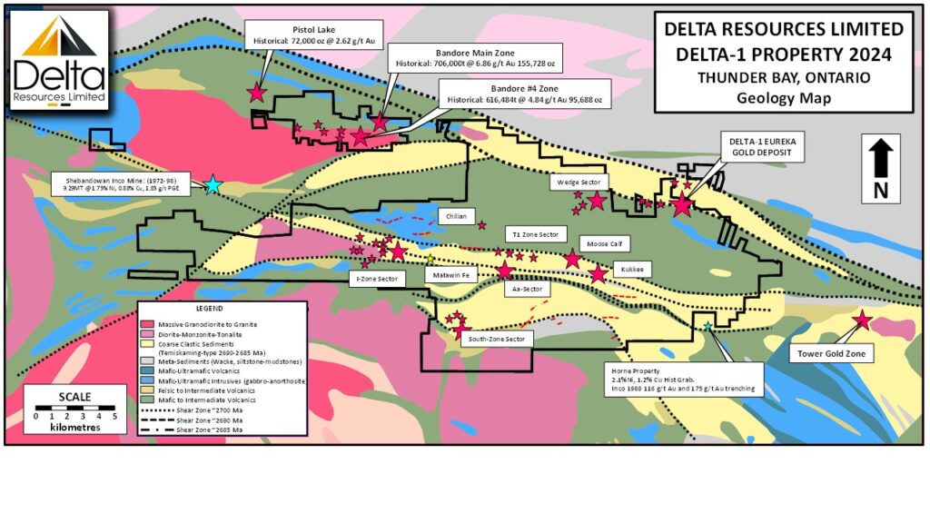
Regional and Property Geology – Discussing the Archean supracrustal rocks of the Shebandowan greenstone belt
Localized Geology – Highlighting the regional fault structures and rock packages.
Gold Mineralization – Covering the controls for mineralization and the five generations of hydrothermal events responsible for gold deposition.
Exploration History – Detailed account of historic work done on the Delta 1 property.
Delta Exploration History – Detailed accounts of Delta’s exploration work
2024 Expanded Exploration and Results – Detailed account of exploration activity 2024.
2025 Exploration – Detailed account of exploration activity to be updated as things develop.
Conclusion – Closing statement.
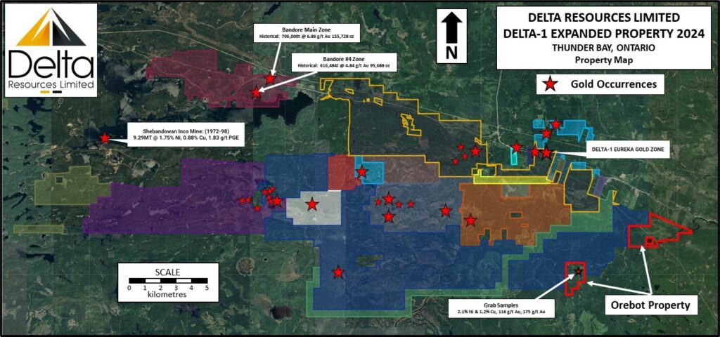
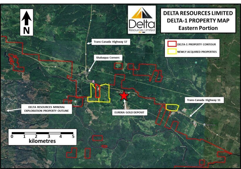
The Delta-1 Project is located in the Shebandowan Greenstone belt, approximately 50 km west of the City of Thunder Bay and along the Trans-Canada highway. The property covers 220 square kilometers and is accessible year-round via the highway and a series of logging roads throughout the property. The company has already outlined a gold zone over 2000 m long, extending from surface to a vertical depth of 250 metres and remains open in all directions. Best grades to date include drill intercepts of 5.92 g/t Au over 31 m, including 14.8 g/t Au over 11.9 m, 2.06 g/t Au over 65.8 m including 4.23 g/t Au over 26.2 m, 1.79 g/t Au over 128.5 m, including 2.16 g/t Au over 97.5 metres, and Bonanza grades of up to 1.6 kg/t and 697 g/t Au over 1.0m.
Figure 1. Delta 1 Property Location

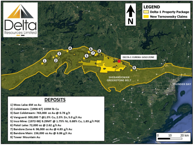
The Shebandowan Structural Zone is a deep-seeded structure that is characterized by intensely deformed rocks, swarms of intrusive units and extensive zones of intense silicification and carbonate, sericite and albite alteration. In excess of 5 million ounces of gold deposits are hosted along a 100-kilometre strike length of the Shebandowan Structural Zone including the low-grade – high-tonnage, multimillion-ounce Moss Lake gold deposit 50 km west of the Delta-1 Property.
Figure 2 – Claim Boundaries (June 2024)

The Archean supracrustal rocks of the Shebandowan greenstone belt belong to one of two contrasting packages of metavolcanic and metasedimentary rocks:
1) an early suite of mafic to felsic metavolcanic rocks of the Burchell and Greenwater assemblages; and
2) a later suite defined as the Shebandowan assemblage, consisting of sedimentary and volcanic rocks that unconformably overlie, and locally straddle, the previous two assemblages (Williams et al., 1991).
Figure 3 – Regional Geology

The older Greenwater assemblage (ca. 2720 Ma) referred to as Keewatin-type, is dominated by mafic to felsic metavolcanic rock cycles consisting of tholeiitic to calc-alkalic andesite, dacite and rhyolite, along with some komatiitic rocks (Rogers and Mercier 1995). It comprises three generally south-younging, bimodal volcanic cycles (Williams et al. 1991).
The younger Shebandowan assemblage (∼2690 Ma) unconformably overlies the Greenwater assemblage and is dominated by clastic metasedimentary rocks, with subordinate calc-alkalic to alkalic intermediate metavolcanic rocks and intrusions (Williams et al. 1991). The clastic sedimentary rocks of the Shebandowan assemblage are often referred to as “Timiskaming-type” because of their similarity to the Timiskaming group rocks of the Abitibi greenstone belt (Cooke and Moorhouse 1969). The Sedimentary rocks of the Shebandowan assemblage are thought to have deposited in fault-bounded basins related to the Shebandowan Structural Zone during regional transpressive deformation at circa 2690 Ma.
In the Shebandowan Belt, the unconformity between the Greenwater and Shebandowan assemblages has a close spatial association with numerous gold occurrences (Stott and Schnieders 1983). The same spatial association is common throughout the Shebandowan, Wawa and Abitibi belts.
Structural Features:
The Shebandowan Structural Zone (ca 2700 Ma) is a deep-seeded structure that marks the boundary between the Quetico and Shebandowan greenstone belt. At least three deformation phases are thought to have taken place (Williams et al. 1991). The Shebandowan region is affected by major northeast and northwest-striking faults.
The Saganaga Structural Zone (ca 2690 Ma) is documented as a sinistral, continental-scale shear zone striking over 200 kilometers from Minnesota northeastward. Timiskaming-like pull apart basins also mark the length of this structural zone with early alkaline volcanics and related intrusions dominating northeast basins.
The Shebandowan region is also affected by late major northeast and northwest-striking faults. The Crayfish Creek and Postans faults are late-stage dextral sense structural zones that may have reactivated the Shebandowan Shear Zone. Later-stage vertical movement is recorded by near-vertical lineations on the fault system at the Wawa-Quetico subprovince boundary.
Regional Mineralization Models include Orogenic Gold Mineralization (Moss Lake, Pistol Lake and Bandore), VMS Mineralization (Coldstream) and Magmatic Ni-Cu-PGE Mineralization (Shebandowan “Inco” Mine).
Near the property, the Greenwater assemblage rocks generally occur south of Highway 11. The rocks are generally mafic to intermediate metavolcanics (including massive and pillowed flows) with local ultramafic flows (locally with spinifex textures). These metavolcanic flows are intercalated with thin horizons of graphitic mudstone, sulphide-bearing chert, jasper-magnetite and chert-magnetite iron formation all of which translate into highly conductive zones. Numerous gabbro sills and dikes intrude the Greenwater assemblage supracrustal rocks throughout this area.
Figure 4 – Property Geology

Shebandowan assemblage rocks are found in the area along and immediately to the north of Highway 11. This assemblage is dominated by clastic metasedimentary rocks, including conglomerate, sandstone, siltstone and mudstone. The rocks are interlayered with distinctive trachyte and trachyandesite flows that commonly display a patchy red and green appearance and tend to be amphibole-phyric. They are intruded by feldspar-phyric felsic to intermediate dikes, gabbroic intrusions and lamprophyre dikes.
Foliation is moderately well developed and generally strikes east-southeast with near-vertical dip. The rocks have been deformed into tight isoclinal folds with east-southeast striking axial planes. Shear zones that parallel the regional foliation occur throughout the area and is especially well developed along trends that coincide with gold-mineralized zones.
Gold mineralization at Delta-1 occurs as two distinct types: The Kasper, South, Creek and Mattawin gold occurrences are hosted by thin horizons of sulphidic and graphitic chert and chert breccia (perhaps sulphidic iron formations). At the Kasper gold occurrence, a banded iron formation is also observed. The rocks are ankeritized and silicified and characterized by an abundance of sulphide (dominantly pyrite with lesser arsenopyrite).
Figures 5 & 6 – Kasper Gold occurrence. To the left, a sulphidic chert looking west (grab sample 8.72 g/t Au). To the right, the spatially associated banded iron formation at Kasper looking north (grab sample 0.08 g/t Au).

At the Eureka and Wedge Gold occurrences gold is associated with an organized stockwork of quartz-ankerite- pyrite veinlets ranging from 1mm to 3cm in width. Occasionally, fine grained disseminated visible gold is observed within the veinlets. Although visible gold is dominantly associated with the pyrite at the walls of the veinlets (Tremblay, 2021) specks of visible gold also occur in the central portions of the quartz veinlets.
In drill core, gold grade is directly proportional to the density of veinlets present. The presence of a single 1cm veinlet in the core can result in gold grades exceeding 1.0 g/t Au over a one metre interval.
Gold mineralization is late and the quartz-ankerite-pyrite gold veinlets crosscut every lithologies including the two types of breccia.
Host rock alteration consists dominantly of intense silicification, ankeritization,sericitization and albitization combined with trace to 2% disseminated pyrite and trace arsenopyrite. At surface, rocks are weathered a dark rusty brown and rock textures are completely obliterated. In drill core and in fresh surface, textures of the sandstone and feldspar-amphibole-phyric intrusive are locally recognized but typically also obliterated. The rock is massive, fine-grained, yellowish buff to pale grey with a common dusting of very fine-grained disseminated pyrite. Even without any veinlets present, the host rock typically contains highly anomalous gold of 0.2 g/t Au to 0.4 g/t Au.
Through exploration drilling, Delta has identified at least five generations of hydrothermal events within an ultramafic breccia with high gold background that predates the gold mineralizing veins of the gold-stockwork (Figure 7):
1) Early, brecciated, white, crack-seal quartz-calcite veinlets (non mineralized),
2) Medium grey, aphanitic siliceous material brecciating the #1 veinlets and containing very fine grained disseminated pyrite.
3) Crack-seal quartz-calcite-chlorite, opaque to translucent veinlets up to 1cm wide with very fine grained disseminated pyrite.
4) Chlorite-pyrite “stylolite-style” seams, and
5) Late, generally tabular, dominantly calcite with quartz unmineralized veinlets.
Figure 7 – Green Breccia from drill hole D1-21-10 at 31m and 32.5m, showing several generations of veinlets. A first generation of white calcite-quartz veinlets with some showing crack-seal textures (1) are crosscut by a second generation of white quartz-calcite-chlorite veinlets (2), in turn crosscut by more tabular quartz-calcite veinlets (3) and finally cut by black, “stylolite-like” chlorite-pyrite seams (4). The lower segment of core shows a few generations of crack-seal textures of calcite-quartz-chlorite (and possible tourmaline) veinlets (5).

These hydrothermal breccias are in turn cut by several generations of gold-bearing veinlets (Figure 8).
Figure 8 – showing several generations of the gold-bearing veinlets of the mineralized stockwork. V1-V2-V3 in each photo indicates the different generations of veinlets. The quartz-ankerite-arsenopyrite-pyrite veinlets shown in the upper two photos are thought to be early in the system and cut by the quartz-ankerite-pyrite veinlets shown in the bottom three photos.

The summary of historical work at the property is divided into the eastern and western portions of the property to better outline the work that has been carried out over the years.
The Eastern portion of the property includes a broad area which incorporates the Gold Cache, Matawin, Eureka and Bylund gold occurrences while the Western Portion of the property includes the Kasper, Creek, West, and South gold occurrences.
1934: Trenching and diamond drilling on the north half of Lots 68 and 69, Concession A by Birch Bay Gold Mines. Noranda Mines investigated mining claims adjacent to the Birch Bay property.
1936: Diamond drilling and trenching by Freeport Exploration Company.
1947–50: The Matawin Gold Mines property was examined by W.D. Neel, M.W. Bartley and T.W. Page.
1966: Self potential survey on a section of the area by Cliffs of Canada.
1970: Geological mapping and geophysical surveys by Noranda Mines Limited.
1972: Getty Mines Limited carried out a detailed program of ground VLF-EM followed by geological mapping, sampling and one drill hole in the eastern portion of the property. Getty mapped an extensive rhyolitic and dacite unit south of Highway 11 which corresponds to the alteration zones mapped during this program. Getty documents south facing clastic sediments north of Highway 11 and north facing volcanics south of the highway. An isoclinal fold is suggested to explain the facing reversal.
1979–81: Lynx Canada Exploration Limited completed five drill holes for a total of 442.5m aimed at a graphitic and cherty horizon at the Matawin Gold occurrence. Best result: 2.17 g/t over 1.22m.
1985–87: Airborne magnetic and electromagnetic surveys, and a soil geochemical survey by Jalna Resources Ltd. This property included the Dawson Road Lots claims, plus the adjacent Gold Cache (located immediately to the west) and Bylund properties (located immediately to the east).
1994–present: Prospecting, outcrop stripping, trenching, sampling and reconnaissance ground magnetic and VLFEM surveys on the adjacent Gold Cache property by T. Kukkee, P. Kukkee and Gold Cache Inc.
1997–99: Freewest Resources and Greater Lenora Resources completed mechanical stripping, soil geochemical surveys, ground magnetometer and induced polarization surveys, sampling, detailed mapping and diamond drilling (5 holes) on the adjacent Bylund property.
2016–Present: Prospecting, sampling and outcrop stripping by D. Parker and B. D’Silva.
1940: M.W. Bartley examined and sampled numerous pits and trenches excavated on the claims of F. Kaspar on the western portion of the property.
1944: Detailed mapping, sampling, and trenching by Sylvanite Gold Mines Limited.
1956: Three Brothers Explorations completed five drill holes for a total of 1,096m in the Shebandowan River area. No assay results are presented.
1972: Johnson completed one drill hole of 151.5m at the property. No assays are documented.
1976: Line cutting, geological mapping, soil sampling, and ground magnetic and electromagnetic surveys by Noranda Exploration Company Limited.
1982: Geological mapping by Noranda.
1983: Geological mapping, ground VLFEM survey, and trench sampling by Lacana Mining Company.
1984: Reconnaissance geological and geochemical surveys by Corporate Oil and Gas Co.
1988: Airborne magnetic and VLFEM surveys by JET Mining Exploration Inc.
1988: Geological mapping and soil geochemical survey by Noranda.
1996–97: Geological mapping, prospecting, and ground magnetic and induced polarization surveys by Avalon Resources Inc.
1997: Geological mapping, prospecting, and ground magnetic survey by Battle Mountain Canada Inc.
2003–05: Diamond drilling (17 holes for 2690 m) and airborne magnetic and electromagnetic surveys by RJK Explorations Ltd.
2016–2020: Prospecting, sampling, trenching and soil geochemical survey by D. Parker and B. D’Silva. Only 42 drill holes have tested this 49 square kilometre property up to 2020. Of these drill holes more than half were aimed at Ni-Cu targets prior to 1972. The last drill program was aimed at two mineral occurrences in 2003.
Since optioning the Delta-1 Property in 2019, Delta has carried out several limited exploration programs in the area adjacent to the Gravel Ridge property. A summary of the exploration work by Delta Resources is provided below:
2019: A six-hole, 1009 m diamond drilling program which showed a very wide zone of low-grade gold mineralization intersected over a 200 meters strike length and extending vertically from the surface to a depth of up to 110 meters.
2020: A 134 sample glacial sediments sampling program which indicated a major in till gold anomaly at the Eureka zone, a second anomaly three kilometers SE of the Eureka gold Prospect, and a Cu-Ni-Co geochemical anomaly west of the Kasper Gold Occurrence.
2020: A geological mapping, prospecting & sampling program which defined the mineralized zone at Eureka as consisting of a broad envelope of low-grade gold, ranging from 0.2 g/t Au to 0.4 g/t Au. This gold halo was defined over a strike length of 1.2 km and a minimum width of 300 m, therefore significantly expanding the lithogeochemical gold halo that was previously defined during the 2019 drilling program.
2021: An eight-hole, 1370 m diamond drilling program which expanded the mineralized zone from the surface to a vertical depth of 150 meters.
2022: An eleven-hole, 3693 m diamond drilling program that has produced the best drill-hole interval so far at the Delta-1 project with hole D1-22-18 returning values of 5.92 g/t gold over 31.0 metres (Including 14.80 g/t Au over 11.9 meters and Including 72.95 g/t Au over 2.2 meters), hole D1-22-24 returning 6.49 g/t Au over 10.0 metres and hole D1-22-25 returning 130.0 g/t Au over 1.0 metre, 1.20 g/t Au over 20.0m and 1.66 g/t Au over 18.1 metres.
2023: From January to March 31, 2023, Delta had completed 3,500 metres of drilling and intersected the gold zone in every drill hole, therefore extending the zone another 500 metres east of drill hole D1-22-25. The zone remained open in all directions.
2023: The success of Delta’s drilling at Delta-1 in early 2023, led to a 10 million dollars bough-deal financing raised at $0.45 per share. Drilling continued after this financing and another 16,700 metres were completed, delineating the gold mineralized zone ver a strike length of 2 kilometres.
2024 (to date): Delta drilled 9,300 metres and is continuing to grow the gold-inventory at Delta-1. As of mid-May 2024, many results were still outstanding.
Shortly after optioning the property in October 2019, Delta completed a drilling program of six drill holes for a total of 1 009 metres. The objective of the drilling was to test the depth extent of gold values obtained by the optionee in surface trenching in 2018 (figures 4-5). Intercepts of up to 0.2 g/t gold were obtained over core lengths of 137 metres within intensely silicified, ankeritized, albitized and sericitized sandstone including gold intercepts of 0.73 g/t Au over 22.0 metres and 0.64 g/t Au over 27.5 metres near surface. Best results of delta’s 2019 drilling program are as follows:
Table 1: Table of best results from Delta’s 2019 drilling program.

Figure 9 – Geology map and location of the drill holes from Delta’s drilling program of 2019. Geology is projected from the drill holes.

Figure 10 – Interpretation of the East and West sections from Delta’s drilling program of 2019. Δ are black-matrix breccia.

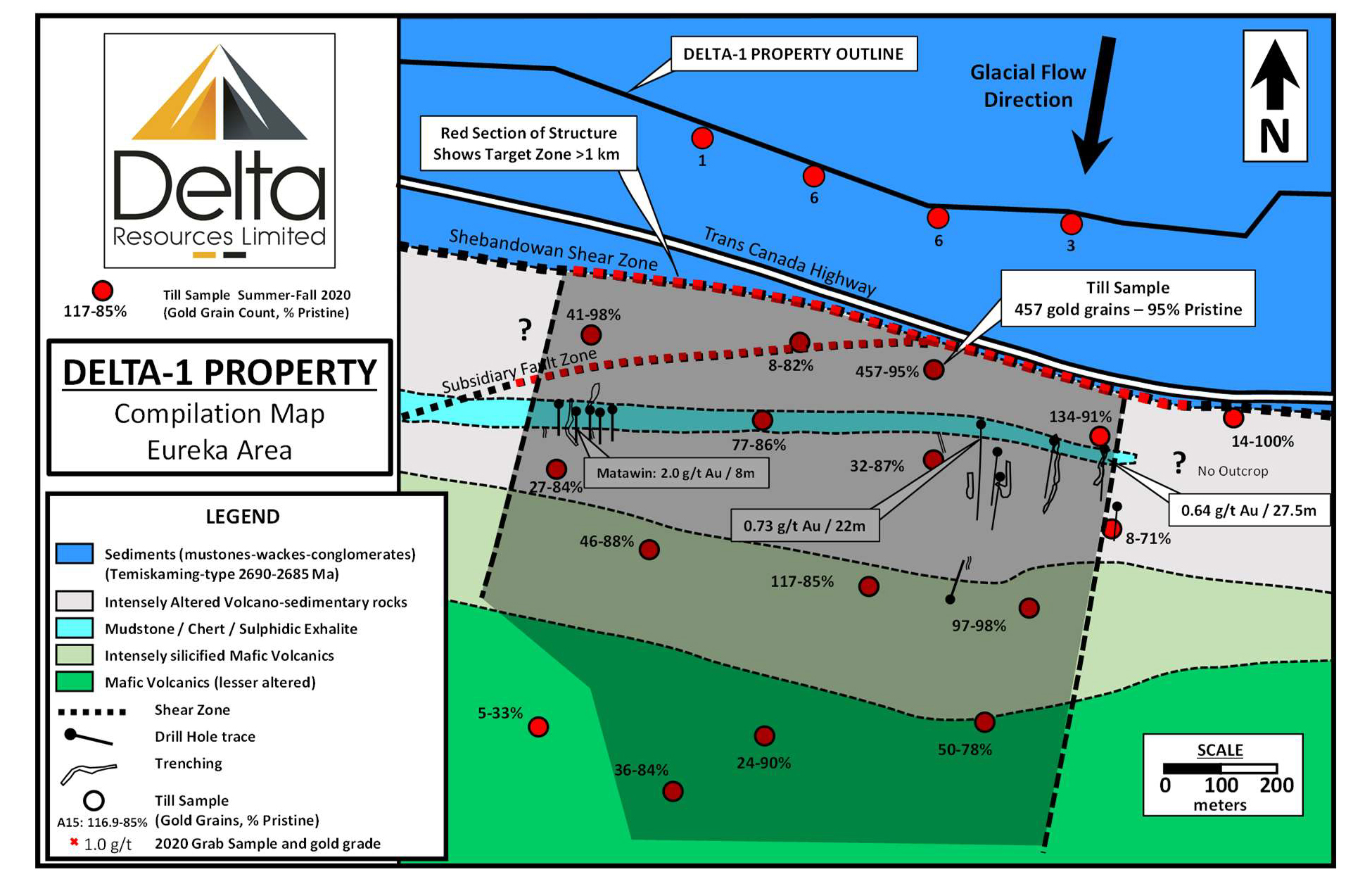
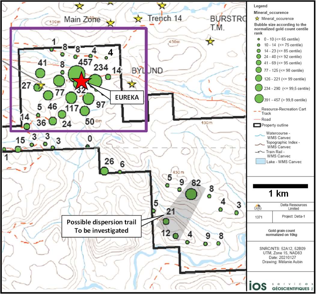
Delta completed a property-scale till survey during the summer of 2020, consisting of 150 till samples and defined a dispersion trail of highly anomalous gold grains in till. The apex of this dispersion trail is nearly 1km in strike and suggests a bedrock gold source north of the Eureka gold occurrence.
Within the dispersion trail, 12 of 13 till samples were shown to contain 24 to 457 gold grains (in 10kg samples) with a proportion of pristine grains accounting for 78% to 98% of the total gold grain count. Also of importance is a line of till samples to the north, at Delta’s northern property boundary, which returned gold grain counts below background, thus confirming the bedrock source of the dispersion trail lies within the limits of the Delta-1 property.
As second gold-in-till dispersion trail is also observed three kilometres SE of Eureka and will be investigated in 2022 (Figure 11).
Figure 11 – Geological map of the Eureka area at the Delta-1 property. The map shows the gold-in-till dispersion trail defined by Delta in the summer of 2020, following a property-scale basal till survey.
In the fall of 2020, Delta carried out a geological mapping, prospecting, and sampling program of the central-east portion of the Delta-1 property, covering an area approximately nine square kilometres which also covered all the gold occurrences known to date at Delta-1. A total of 187 outcrops or groups of outcrops were described and sampled. (See Figure 12)
Figure 12 – Gold-in-till map showing a second dispersion trail located 3 kilometres SE of Eureka.
The most significant conclusion of this work was to outline a large lithogeochemical gold halo exceeding 0.2 g/t Au over a minimum strike length of 1.2km and a minimum width of 300m, therefore significantly expanding the lithogeochemical gold halo that was previously defined during the 2019 drilling program (see figure 13).
Figure 13 – Geological map of the Eureka area at the Delta-1 property. Geological compilation map from Delta’s mapping 2020 combined with a map from Gettys, 1972. The map shows the result of lithogeochemical sampling and mapping from Delta’s 2020 fall mapping program which outlined a low-grade gold halo Delta at Eureka.

Delta completed a total of 1,376 metres of drilling in eight NQ-size drill holes. The objective of the drilling was to:
Because of the logistics of crossing the Trans Canada Highway, drill holes D1-21-07, 08, 12 and 14 were drilled towards the north, underneath the highway. All these drill holes missed the mineralized zone altogether and as a result the gold in till anomaly remains unexplained.
Nevertheless, Delta’s 2021 drill program extended the gold mineralized zone to a strike length of nearly 450 metres and a vertical depth of 150 metres. The zone strikes EW and dips 50 degrees towards the north. The gold zone is 100 to 180 metres in width with grades of 0.2 g/t to 0.4 g/t gold. Within that low-grade zone lies a 20m wide zone of ~1.0 g/t Au.
Location of the drill holes from 2019 and 2021 and best results of 2021 are shown below in figure 14.
Figure 14 – Surface map showing the position of the drill holes from delta’s 2019 and 2021 drilling program. A total of 2 385 metres have been drilled so far at Eureka to define this zone
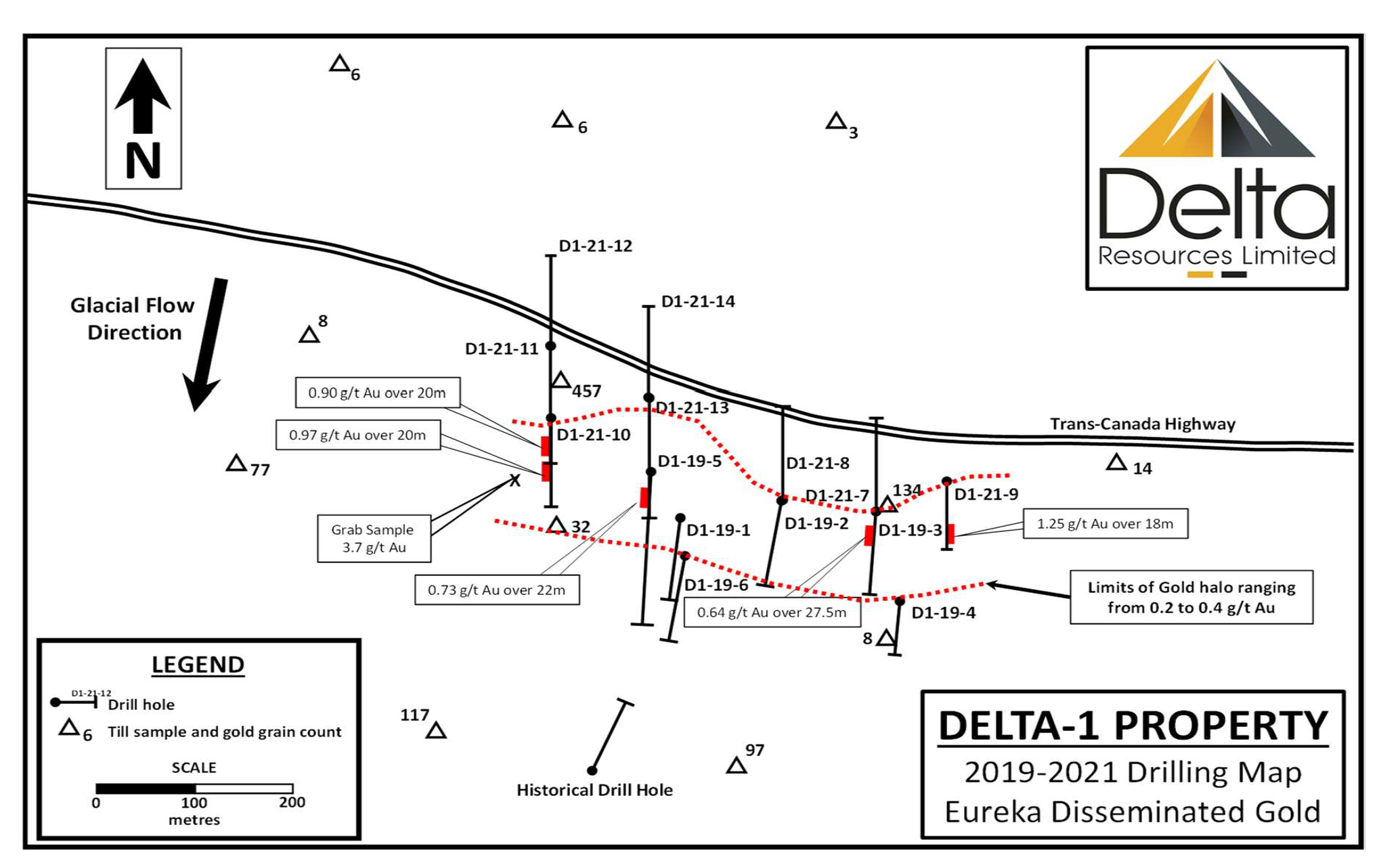
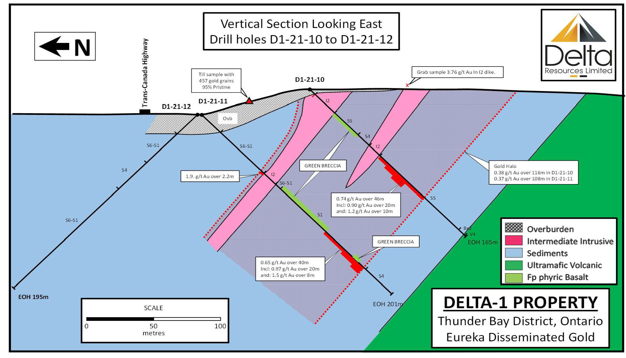
Figure 15 – Vertical Geological Section of drill holes D1-21-10, D1-21-11 and D1-21-12, looking East. The section shows the mineralized zone dipping 40° to 45° towards the north sub parallel to the feldspar-amphibole intermediate dikes. The bedrock source of the gold in till anomaly remains untested due to the depth of overburden and the inclination of drill hole 12.
As can be seen above, the team has had great success with intersections of up to 10.1 g/t Au over 1m in drill hole D1-21-07 as well as several other intersections ranging from 1.5 g/t Au to 5.05 g/t Au over 1m. The size and intensity of the mineralizing system was just beginning to point to a potentially sizeable gold deposit and warranted additional exploration in 2022. Therefore, the Delta 1 project was prioritized and the team set out to extend the strike, width and depth of the known mineral deposit and locate the bedrock source of the till samples which highlight more than a kilometer of strike.
For the first part of 2022 Delta focused on gathering data and began planning an expanded drill program. The drill program was set to drill 10 holes for a combined 3,000 metres along the previously identified trend called Eureka Gold Zone. This area was outlined by only 1,680 metres of drilling over an area of 450 metres long and 20 metres wide, extending from surface to 150 metres vertical.
Delta received a grant of $200,000 from the The Ontario Junior Exploration Programin May
From May 10 to June 6, 2022, Delta completed a total of 2,719 metres of drilling in nine (9) drill holes and a total of 1,793 samples were collected and sent to SGS laboratories in Sudbury, Ontario. Visible gold was observed in four (4) of the nine (9) drill holes, and the rocks continued to be intensely silicified, sericitized, and ankeritized. During the program the company expanded the zone to a strike length of 830 metres and a vertical depth of up to 250 metres.
Figure 16 – Delta 1 – VG in Drill core


The early success prompted the company to acquire the surface and mining rights of a property adjacent and contiguous to the Delta-1 property. The 85-hectare land package is immediately east of the Eureka Gold Prospect and opens up additional exploration opportunities along trend. With this agreement, Delta controlled an area of 57.6 square-kilometres, straddling the Shebandowan Structural Zone which has seen an increase in exploration activity through 2021/22 from the likes of White Metals Corp and Goldshore Resources.
Earlier in the year, Delta acquired the services of Insidexploration to film and produce a few short videos describing the mineralization, alteration, drilling and the overall goals of the exploration program. A site visit was conducted in mid September to film at the tail end of the drill campaign. See videos below
On October 19th, Delta announced results from a total of 2,719 metres drilled in nine drill holes.
Highlights include
Figure 17 – Plan view map showing locations of the drill holes. (Note: The geology has been projected up-dip to the surface).

Table 2 – DELTA-1 Eureka Zone 2019 and 2021 DRILL INTERCEPTS
| DRILL HOLE NO | Easting (UTM Zone 16) | Northing (UTM Zone 16) | Azimuth | Incl. | Length (m) | FROM (m) | TO (m) | Au Grade (g/t) | CORE LENGTH (m) |
| D1-19-02 | 289720 | 5385359 | 180 | -50 | 174.0 | 95.50 | 110.60 | 0.33 | 15.10 |
| D1-19-03 | 289815 | 5385345 | 180 | -50 | 159.0 | 14.00 | 36.10 | 0.72 | 22.10 |
| incl. | 14.00 | 27.80 | 0.84 | 13.80 | |||||
| incl. | 21.00 | 25.50 | 1.26 | 4.50 | |||||
| D1-19-05 | 289584 | 5385391 | 180 | -45 | 264.0 | 35.00 | 56.00 | 0.75 | 21.00 |
| incl. | 42.00 | 56.00 | 0.82 | 14.00 | |||||
| D1-21-09 | 289883 | 5385385 | 168 | -45 | 105.0 | 6.00 | 105.00 | 0.41 | 99.00 |
| incl. | 6.00 | 39.50 | 0.46 | 33.50 | |||||
| incl. | 73.00 | 91.00 | 1.25 | 18.00 | |||||
| incl. | 73.00 | 74.00 | 10.10 | 1.00 | |||||
| D1-21-10 | 289486 | 5385450 | 181.2 | -45 | 165.0 | 5.00 | 121.00 | 0.38 | 116.00 |
| incl. | 13.50 | 18.00 | 0.73 | 4.50 | |||||
| incl. | 75.00 | 121.00 | 0.74 | 46.00 | |||||
| incl. | 75.00 | 103.00 | 0.84 | 28.00 | |||||
| incl. | 83.00 | 103.00 | 0.90 | 20.00 | |||||
| incl. | 83.00 | 93.00 | 1.20 | 10.00 | |||||
| D1-21-11 | 289484 | 5385535 | 177.7 | -45 | 201.0 | 63.00 | 171.00 | 0.37 | 108.00 |
| incl. | 131.00 | 171.00 | 0.65 | 40.00 | |||||
| incl. | 151.00 | 171.00 | 0.96 | 20.00 | |||||
| D1-21-13 | 289581 | 5385486 | 174.7 | -44 | 194.0 | 56.50 | 128.00 | 0.31 | 71.50 |
| incl. | 82.00 | 89.00 | 7.00 | 7.00 | |||||
| incl. | 118.00 | 128.00 | 0.71 | 10.00 | |||||
| Total: | 1262.0 |
Table 2a – DELTA-1 Eureka Zone 2022 DRILL INTERCEPTS (Continued)
| DRILL HOLE NO | Easting (UTM Zone 16) | Northing (UTM Zone 16) | Azimuth | Incl. | Length (m) | FROM (m) | TO (m) | Au Grade (g/t) | CORE LENGTH (m) |
| D1-22-15 | 289776 | 5385624 | 180 | -45 | 464.4 | 274.50 | 286.00 | 0.53 | 11.50 |
| 431.40 | 442.30 | 0.38 | 10.90 | ||||||
| D1-22-16 | 289532 | 5385660 | 180 | -40 | 348.0 | 313.30 | 320.50 | 0.35 | 7.20 |
| D1-22-17 | 289682 | 5385631 | 180 | -45 | 352.4 | 191.00 | 254.40 | 0.39 | 63.40 |
| incl. | 191.00 | 192.00 | 1.12 | 1.00 | |||||
| incl. | 200.00 | 219.00 | 0.52 | 19.00 | |||||
| incl. | 200.00 | 203.20 | 1.12 | 3.20 | |||||
| incl. | 236.00 | 240.60 | 1.16 | 4.60 | |||||
| and | 341.00 | 351.00 | 0.36 | 10.00 | |||||
| D1-22-18 | 289955 | 5385581 | 180 | -45 | 360.0 | 127.30 | 128.50 | 1.19 | 1.20 |
| and | 212.90 | 214.00 | 1.19 | 1.10 | |||||
| and | 293.00 | 324.00 | 5.92 | 31.00 | |||||
| incl. | 308.10 | 320.00 | 14.80 | 11.90 | |||||
| incl. | 314.00 | 316.20 | 72.95 | 2.20 | |||||
| and | 358.00 | 360.00 | 1.34 | 2.00 | |||||
| D1-22-19 | 289371 | 5385484 | 180 | -45 | 252.0 | 10.60 | 12.00 | 1.29 | 1.40 |
| 26.00 | 36.50 | 1.55 | 10.50 | ||||||
| 90.00 | 224.00 | 0.33 | 134.00 | ||||||
| incl. | 104.00 | 107.50 | 1.13 | 3.50 | |||||
| incl. | 127.00 | 127.70 | 2.00 | 0.70 | |||||
| incl. | 141.00 | 142.00 | 1.95 | 1.00 | |||||
| incl. | 170.00 | 189.00 | 0.62 | 19.00 | |||||
| incl. | 170.00 | 174.00 | 0.96 | 4.00 | |||||
| D1-22-20 | 289281 | 5385478 | 180 | -45 | 237.0 | 6.00 | 7.00 | 1.73 | 1.00 |
| 69.00 | 179.00 | 0.32 | 110.00 | ||||||
| incl. | 121.00 | 179.00 | 0.37 | 58.00 | |||||
| incl. | 121.00 | 127.00 | 1.39 | 6.00 | |||||
| D1-22-21 | 289174 | 5385475 | 189 | -45 | 198.0 | 6.00 | 60.00 | 0.36 | 54.00 |
| incl. | 6.00 | 12.00 | 1.73 | 6.00 | |||||
| incl. | 10.00 | 11.00 | 7.95 | 1.00 | |||||
| incl. | 38.00 | 40.50 | 1.00 | 2.50 | |||||
| D1-22-22 | 289084 | 5385500 | 180 | -45 | 204.0 | 53.50 | 59.50 | 2.74 | 6.00 |
| incl. | 56.50 | 58.00 | 9.62 | 1.50 | |||||
| D1-22-23 | 289184 | 5385563 | 180 | -45 | 303.0 | 56.00 | 57.00 | 2.58 | 1.00 |
| 66.00 | 138.00 | 0.41 | 72.00 | ||||||
| 109.50 | 130.50 | 0.79 | 21.00 | ||||||
| incl. | 109.50 | 124.50 | 0.93 | 15.00 | |||||
| incl. | 109.50 | 111.00 | 6.21 | 1.50 | |||||
| Total: | 2718.8 | |
After the results were released, a drill was brought back into the property to drill a couple more holes before the season came to an end and both holes were again reported to contain VG. Holes D1-22-24 and D1-22-25 were collared respectively 50 metres and 100 metres east of drill hole D1-22-18, aimed to test the eastern extension of the gold intercept.
December 15th 2022, Delta announced the closing of a $945,700 private placement whereby Troilus Gold make a strategic investment in Delta.
Final assay results from 2022 were released on February 9, 2023. Gold mineralization was intersected in both drill holes, extending the Eureka Gold Zone to nearly one kilometre of strike length. The drill holes returned high-grade intercepts of 130.0 g/t Au over 1.0 metre, 30.66 g/t Au over 1.0 metre (within a broader interval of 6.5 g/t Au over 10.0 metres) and 16.42 g/t Au over 1.5 metres, alongside or within broader mineralized intervals. Intervals are reported in Table 3 below.
Table 3 – DELTA-1 Drill intercepts for holes D1-22-18/24 and 25

Figure 18 – Geology map showing locations of all drill holes at the Eureka Gold Zone.(Note: The geology is projected to the surface from the drill holes). Assay results are shown from easternmost drill intercepts including drill holes D1-22-24 and D1-22-25.

Figure 19 – Vertical longitudinal section looking 010 degrees azimuth showing drill hole pierce points, grades and metal factors on the whole Eureka Gold Zone including those of drill holes D1-22-24 and D1-22-25

In January 2023, Delta launched another drill campaign aimed at continuing the eastern extension of the Eureka Deposit with an additional 6 holes.
On February 16th, 2023 Delta acquired the exclusive rights to buy the surface and mining rights to an additional property adjacent to the Delta-1 property package. The 47-hectare property is contiguous with the Delta-1 property and located immediately west of the Eureka Gold Zone. Delta has now secured a land position on strike with the Eureka gold deposit for a strike length exceeding 4.5 kilometres and now controls an area of 58.8 square-kilometres straddling the Shebandowan Structural Zone in the Shebandowan Greenstone Belt.
With continued success, the January drill program was extended and as the core was being logged and split, additional visible gold was discovered and reported on March 1st.
New observations suggest that the high-grade gold zone extends 600 metres towards east from drill hole D1-22-18 and that the broader mineralized zone is defined over a strike length of 1.35 kilometres with the vertical depth having been tested up to approximately 220 metres. The mineralized zone trends roughly 100°-110° azimuth, dips between 50° and 80° towards the north and remains open in all directions and at depth.
Figure 20 – Photo of visible gold in quartz-carbonate-pyrite veinlet from drill hole D1-23-30 at 79.7 m. Hole is located 200 m east of D1-22-18

Figure 21 – Photo of visible gold in quartz-carbonate-pyrite veinlet from drill hole D1-23-31 at 93.9 m. Hole is located 300 m east of D1-22-18

Figure 22: Plan view map showing locations of the new drill holes from the ongoing drill program.

On March 21st Delta provided a drill campaign update, details on their geological interpretations of the Eureka Gold deposit and assays for a previously reported drill hole.
Drill hole D1-22-24 was announced on February 9th with gold intercept of 5.32 g/t over 8.0 metres on drill hole D1-22-24. The additional metallic sieve analyses of the mineralized zone increased the gold intercept to 6.49 g/t gold over 10.0 metres with an additional one metre sample returning 22.22 g/t gold.
New Geophysical and Geological Interpretation:
As Delta continues its current drill campaign at Delta-1, new structural and geophysical insights on the Eureka mineralized zone have emerged that significantly enlarged the potential area for gold on the property.
Figure 23: Magnetic map of the Eureka Gold Zone and its projected extensions. The projected zone is characterized by a magnetic low (in blue). The geophysical signature of the zone suggests that it turns at 115 degrees azimuth and extends towards the east for a minimum strike length of two kilometres. The inflection in the structure may be responsible for the higher-grade gold mineralization in the area.

Figure 24: Vertical cross-section of drill holes D1-21-19 and D1-22-18 looking east. The section shows the mineralized zone to be dipping steeply at 80 degrees towards the north, in the eastern portion of the Eureka Gold Zone.

On April 12, 2023 – Delta announced assay results from the first five drill holes from the 2023-Phase 1 drill program. All five drill holes reported, intersected broad zones of favourable alteration and gold mineralization with drill hole D1-23-30, the easternmost and deepest drill hole reported to date returning assays of:
Drill hole D1-23-30 is located one hundred metres east of drill hole D1-22-25, previously reported on February 9, 2023 (see long section and map attached). Assays are pending on seven additional drill holes to the east and results will be released in the coming weeks as they are certified by SGS Lab and pass all of Delta’s QA/QC protocols.
Drill holes D1-23-26 to D1-23-28 were drilled above drill holes D1-22-18, D1-22-22 and appear to have intersected the gold-mineralized halo surrounding the higher-grade gold zones. The mineralized zone in drill hole D1-23-29 is cut by a late, post-mineral diabase dike that locally splits the gold zone into two smaller zones. Complete drill results are shown in Table 4 below, including the previously released drill holes D1-22-18, 24 and 25 (true widths are believed to be 60% to 87% of reported lengths depending on the inclination of drill holes).
Table 4 – 2023 drill intercepts

Figure 25: Vertical longitudinal section looking north 010° of the eastern portion of the Delta-1 Gold Zone showing piercing points of drill holes with grades and metal factors. The section shows the metal factors increasing towards the east and at depth, as defined by drill holes D1-22-18, 24, 25 and D1-23-30.

Figure 26 – Total magnetic map showing the projected gold-mineralized zone at Delta-1, with gold grades for drill holes D1-22-18, 24, 25 and D1-23-30.

Additional results were released on April 20th for holes D1-23-31 and D1-23-32. Both were drilled on the same drill-pad and define a North-South section, 100 metres east of an intercept of 4.23 g/t Au over 26.2 metres from drill hole D1-23-30 reported on April 12, 2023 and 300 metres from an intercept of 5.92 g/t Au over 31.0 metres in drill hole D1-22-18 reported on October 15, 2022 (see figures 27 and 28).
Hole D1-23-31 intersected 1.29 g/t Gold over 97.0 Metres and hole D1-23-32 intersected 238 metres grading .55 g/t Gold. (See Figure 27)
Figure 27 – Total magnetic map showing the projected gold-mineralized zones at Delta-1.

Table 5 – Additional results from the 2023 drill campaign

Figure 28 – Vertical cross-section of the Delta-1 Gold Zone looking east, showing the newly interpreted Alpha, Beta and Gamma Zones

On April 24th a new drill campaign was initiated aimed at the deep blue portions of the Mag survey to the east.
On April 25th, 2023 Delta announced the results of two additional holes in holes D1-23-33 and D1-23-34. Both holes were drilled on the same drill-pad and define a 2-hole fan on a North-South section located 100 metres east of an intercept of 1.29 g/t Au over 97.0m from drill hole D1-23-31, 200 metres east from another intercept of 4.23 g/t Au over 26.2 metres from drill hole D1-23-30 and 400 metres east from an intercept of 5.92 g/t Au over 31.0 metres in drill hole D1-22-18 (see figure 25). Both drill holes D1-23-33 and D1-23-34 are collared in mineralization and intercepted wide zones of near-surface gold in intensely altered rocks.
Figure 29 -Total magnetic map showing the up-dip projection of the gold-mineralized zones at Delta-1. Results highlighted in yellow are new. Note the association of the mineralized zones with a magnetic low which corresponds to magnetite destructive alteration. Assay results are pending for three more drill holes to the east.

T
able 6 – Drill holes D1-23-33 and D1-23-34

Figure 30 – Vertical cross-section of the Delta-1 Gold Zone looking east, showing drill holes D1-23-33 and 34.

On May 4th, 2023 Delta added 8 land claims near the Delta-1 Project bringing the total land area to 58.8 sqr kilometres.
On May 11th, 2023 results from the last four drill holes of our 2023 Phase 1 drill program highlighted by 1636 g/t and 697 g/t Gold over 1.0 metre Intervals and reported more visible gold in two step-out holes in the initial phase 2 drilling.
Wide intercepts of gold mineralization were intersected near surface in drill holes D1-23-35 and D1-23-36, extending mineralization an additional 100 metres east of the previously reported drill holes.
Drill hole D1-23-38 intersected exceptionally high-grade gold mineralization in narrower intervals east of a NE-trending cross fault that displaced the mineralized zone towards the south. It is unclear at this point how this high-grade mineralization correlates with the very wide intervals of lower grade west of the cross structure. Vein widths, density of veining and grade distribution can be highly variable within these large gold systems and hole D1-23-38 is typical of that variability along the favourable structure and geophysical target.
Figure 31 – Vertical longitudinal section looking north 010° of the eastern portion of the Delta-1 Gold Zone showing piercing points of drill holes with grades and metal factors. New results from this release are highlighted in yellow.

Table 7 – Drill Holes D1-23-35/36/37/38

In addition to these results, the company announced the completion of the first step out drill holes from the second phase of drilling announced April 24th. In yet another step out of 100 metres east of drill hole D1-23-38, drill holes D1-23-40 and D1-23-41, appear to mark a return to the very wide intervals of gold mineralization with visible gold observed in both drill holes. Drill holes D1-23-40 and D1-23-41 are the first drill holes directly testing the “Deep Blue” Target.
Figure 32 – Total magnetic map showing the up-dip projection of the gold-mineralized zones at Delta-1. Note the association of the mineralized zones with a magnetic low which corresponds to magnetite destructive alteration.

Figure 29 – Vertical cross-section of the Delta-1 Gold Zone looking east, showing drill holes D1-23-35 and 36

On May 17, 2023, Delta closed a $10 million dollar bought deal financing, and the Company ramped up its exploration efforts at Delta 1. On June 6th, 2023, the company announced the start of a 20,000 metre drill program and the mobilization of a second drill rig to further accelerate the drill campaign. The program is designed to expand the current mineralized zone along strike and at depth, while testing property-scale targets with similar geological and geophysical signatures as the Eureka Gold Zone.
Following the previously announced acquisitions on September 7, 2022, October 31, 2022, December 13, 2022, February 16, 2023, and May 4, 2023, Delta acquired the exclusive rights to an additional four (4) mineral exploration properties covering a total of approximately 4,716 hectares contiguous to its Delta-1 property package in July of 2023.
During the course of 2023, Delta completed sixty (60) drill holes for a total of 19,620 metres at the Delta-1 project. That brought the total drilling at the property to eighty-six (86) drill holes or 26,288 metres, since Delta’s 2019 acquisition of the project. Other exploration work at the property in 2023 included a geological mapping, prospecting and sampling program that covered approximately ten (10) square kilometres as well as a 3D induced polarization geophysical survey and a high-resolution drone magnetic survey.
The objective of the expanded exploration program was to follow-up on Delta’s discovery drill holes released in October 2022 and January 2023, including D1-22-18: 5.92 g/t Au over 31.0 metres including 14.8 g/t Au over 11.9 metres, D1-22-24: 6.49 g/t Au over 10.0 metres and D1-22-25: 130.0 g/t Au over 1.0 metre, 1.2 g/t Au over 20.0 metres and 1.66 g/t Au over 18.1 metres.
Full drill tables of results in 2023 below:
TABLE 8 (part 1): Table of 2023 drill results intersecting the gold mineralized zone.
| DRILL HOLE NO | Easting | Northing | Elevation (m) | Azimuth | Incl. | Length (m) | FROM (m) | TO (m) | Au Grade (g/t) | CORE LENGTH (m) |
| (UTM Zone 16) | ||||||||||
| D1-23-26 | 289946 | 5385384 | 438 | 180 | -58 | 300.0 | 8.70 | 138.50 | 0.37 | 129.80 |
| D1-23-27 | 290051 | 5385389 | 435 | 180 | -40 | 270.0 | 16.80 | 110.00 | 0.45 | 93.20 |
| incl. | 16.80 | 77.00 | 0.54 | 60.20 | ||||||
| D1-23-28 | 290051 | 5385390 | 434 | 180 | -68 | 300.0 | 44.90 | 62.00 | 0.63 | 17.10 |
| 105.00 | 117.60 | 1.91 | 12.60 | |||||||
| incl. | 105.00 | 113.60 | 2.46 | 8.60 | ||||||
| D1-23-29 | 290151 | 5385354 | 443 | 180 | -40 | 231.0 | 79.00 | 85.00 | 2.29 | 6.00 |
| 85.00 | 93.90 | Late Diabase Dike | ||||||||
| 93.90 | 99.00 | 1.37 | 5.10 | |||||||
| D1-23-30 | 290150 | 5385355 | 443 | 180 | -65 | 303.0 | 51.20 | 59.10 | 0.62 | 7.90 |
| 73.20 | 236.00 | 0.97 | 162.80 | |||||||
| incl. | 73.20 | 139.00 | 2.06 | 65.80 | ||||||
| incl. | 76.00 | 102.20 | 4.23 | 26.20 | ||||||
| incl. | 79.00 | 80.10 | 49.91 | 1.10 | ||||||
| 217.00 | 236.00 | 0.74 | 19.00 | |||||||
| D1-23-31 | 290253 | 5385380 | 444 | 180 | -40 | 247.5 | 36.00 | 133.00 | 1.29 | 97.00 |
| incl. | 36.00 | 45.50 | 1.04 | 9.50 | ||||||
| incl. | 58.00 | 133.00 | 1.54 | 75.00 | ||||||
| incl. | 93.50 | 94.40 | 36.59 | 0.90 | ||||||
| incl. | 124.10 | 125.00 | 46.81 | 0.90 | ||||||
| 198.00 | 204.00 | 0.79 | 6.00 | |||||||
| D1-23-32 | 290253 | 5385381 | 444 | 180 | -65 | 303.0 | 42.30 | 280.50 | 0.55 | 238.20 |
| 42.30 | 176.00 | 0.61 | 133.70 | |||||||
| incl. | 54.00 | 76.50 | 1.25 | 22.50 | ||||||
| 243.50 | 280.50 | 1.15 | 37.00 | |||||||
| incl. | 271.50 | 280.50 | 2.62 | 9.00 | ||||||
| D1-23-33 | 290367 | 5385355 | 450 | 180 | -40 | 261.0 | 14.80 | 104.50 | 1.15 | 89.70 |
| 14.80 | 36.00 | 2.87 | 21.20 | |||||||
| Incl. | 23.00 | 24.00 | 45.44 | 1.00 | ||||||
| 49.00 | 104.50 | 0.73 | 55.50 | |||||||
| incl. | 103.00 | 104.50 | 12.05 | 1.50 | ||||||
| 173.50 | 193.00 | 0.72 | 19.50 | |||||||
| D1-23-34 | 290368 | 5385357 | 449 | 180 | -70 | 144.3 | 33.00 | 142.00 | 0.86 | 109.00 |
| incl. | 33.00 | 75.50 | 1.31 | 42.50 | ||||||
| incl. | 33.00 | 45.00 | 2.08 | 12.00 | ||||||
| incl. | 50.50 | 75.50 | 1.21 | 25.00 | ||||||
| 115.50 | 142.00 | 1.11 | 26.50 | |||||||
| D1-23-35 | 290464 | 5385361 | 436 | 180 | -40 | 258.0 | 25.00 | 32.00 | 1.23 | 7.00 |
| 89.00 | 143.00 | 0.80 | 54.00 | |||||||
| 168.00 | 170.10 | 2.15 | 2.10 | |||||||
| D1-23-36 | 290464 | 5385362 | 436 | 180 | -65 | 354.0 | 41.00 | 50.00 | 1.76 | 9.00 |
| 137.00 | 162.50 | 0.80 | 25.50 | |||||||
| D1-23-37 | 289882 | 5385377 | 438 | 180 | -70 | 312.0 | 18.00 | 122.60 | 0.37 | 104.60 |
| 141.00 | 294.50 | 0.44 | 153.50 | |||||||
| incl. | 272.10 | 289.60 | 2.06 | 17.50 | ||||||
| D1-23-38 | 290602 | 5385206 | 446 | 180 | -45 | 222.5 | 62.80 | 63.80 | 1636.00 | 1.00 |
| 69.00 | 70.00 | 697.00 | 1.00 | |||||||
| 90.00 | 95.00 | 1.73 | 5.00 | |||||||
| 107.00 | 108.00 | 9.78 | 1.00 | |||||||
| D1-23-39 | 290602 | 5385207 | 445 | 180 | -70 | 378.0 | 68.20 | 107.00 | 0.70 | 38.80 |
| 236.00 | 239.00 | 1.24 | 3.00 | |||||||
| incl. | 251.00 | 257.00 | 1.24 | 6.00 | ||||||
| D1-23-40 | 290709 | 5385221 | 431 | 180 | -45 | 340.8 | 86.00 | 214.50 | 0.34 | 128.50 |
| incl. | 130.00 | 146.40 | 0.92 | 16.40 | ||||||
| incl. | 163.70 | 180.10 | 0.84 | 16.40 | ||||||
TABLE 8 (part 2): Table of 2023 drill results intersecting the gold mineralized zone.
| DRILL HOLE NO | Easting | Northing | Elevation (m) | Azimuth | Incl. | Length (m) | FROM (m) | TO (m) | Au Grade (g/t) | CORE LENGTH (m) |
| (UTM Zone 16) | ||||||||||
| D1-23-41 | 290713 | 5385122 | 443 | 180 | -45 | 225.0 | 25.80 | 31.50 | 1.05 | 5.70 |
| 81.00 | 159.00 | 0.34 | 78.00 | |||||||
| incl. | 81.00 | 111.50 | 0.58 | 30.50 | ||||||
| D1-23-42 | 290595 | 5385295 | 443 | 180 | -45 | 247.1 | 49.00 | 54.00 | 2.96 | 5.00 |
| incl. | 76.00 | 80.10 | 3.34 | 4.10 | ||||||
| D1-23-53 | 290364 | 5385203 | 452 | 180 | -45 | 411.0 | 8.00 | 50.00 | 1.18 | 42.00 |
| incl. | 22.00 | 23.00 | 37.80 | 1.00 | ||||||
| D1-23-54 | 290144 | 5385547 | 425 | 180 | -45 | 525.0 | 278.00 | 318.20 | 0.58 | 40.20 |
| incl. | 302.90 | 318.20 | 1.00 | 15.30 | ||||||
| incl. | 305.40 | 306.20 | 10.00 | 0.80 | ||||||
| D1-23-60 | 290200 | 5385387 | 442 | 180 | -45 | 276.0 | 25.50 | 154.00 | 1.79 | 128.50 |
| incl. | 25.50 | 123.00 | 2.16 | 97.50 | ||||||
| incl. | 25.50 | 90.00 | 2.56 | 64.50 | ||||||
| incl. | 46.00 | 47.00 | 14.10 | 1.00 | ||||||
| incl. | 75.00 | 76.50 | 51.40 | 1.50 | ||||||
| incl. | 122.00 | 123.00 | 24.50 | 1.00 | ||||||
| D1-23-61 | 290308 | 5385381 | 446 | 180 | -45 | 300.0 | 13.00 | 165.40 | 0.58 | 152.40 |
| incl. | 52.30 | 165.40 | 0.70 | 113.10 | ||||||
| incl. | 13.00 | 16.00 | 1.62 | 3.00 | ||||||
| incl. | 55.00 | 90.00 | 0.98 | 35.00 | ||||||
| incl. | 140.00 | 165.40 | 1.18 | 25.40 | ||||||
| D1-23-62 | 290605 | 5385206 | 444 | 330 | -40 | 300.0 | 26.70 | 44.00 | 0.95 | 17.30 |
| incl. | 71.00 | 83.00 | 0.55 | 12.00 | ||||||
| incl. | 106.50 | 133.00 | 0.62 | 26.50 | ||||||
| D1-23-64 | 290405 | 5385369 | 445 | 180 | -45 | 300.0 | 61.50 | 107.70 | 0.47 | 46.20 |
| 129.50 | 168.00 | 1.37 | 38.50 | |||||||
| incl. | 143.00 | 151.60 | 4.82 | 8.60 | ||||||
| D1-23-65 | 290534 | 5385339 | 436 | 180 | -45 | 351.0 | 84.00 | 119.50 | 1.39 | 35.50 |
| incl. | 84.00 | 109.00 | 1.81 | 25.00 | ||||||
| D1-23-67 | 290659 | 5385262 | 435 | 180 | -45 | 378.0 | 39.00 | 79.20 | 0.66 | 40.20 |
| incl. | 59.00 | 79.20 | 0.95 | 20.20 | ||||||
| 282.80 | 284.30 | 24.40 | 1.50 | |||||||
| D1-23-68 | 290715 | 5385361 | 432 | 180 | -45 | 600.0 | 237.50 | 303.40 | 0.54 | 65.90 |
| incl. | 270.50 | 303.40 | 0.73 | 32.90 | ||||||
| 406.00 | 446.50 | 0.80 | 40.50 | |||||||
| incl. | 409.00 | 436.30 | 0.98 | 27.30 | ||||||
| 539.50 | 540.50 | 12.50 | 1.00 | |||||||
| incl. | 574.50 | 576.00 | 11.20 | 1.50 | ||||||
| D1-23-69 | 290101 | 5385390 | 437 | 180 | -60 | 276.0 | 48.80 | 76.60 | 2.25 | 27.80 |
| incl. | 73.60 | 75.60 | 16.16 | 2.00 | ||||||
| 120.10 | 141.20 | 0.46 | 21.10 | |||||||
| incl. | 129.20 | 141.20 | 0.58 | 12.00 | ||||||
| 153.20 | 161.00 | 0.82 | 7.80 | |||||||
| 229.50 | 250.50 | 0.55 | 21.00 | |||||||
| D1-23-70 | 289998 | 5385398 | 436 | 180 | -45 | 300.0 | 39.60 | 97.00 | 0.38 | 57.40 |
| incl. | 73.50 | 94.00 | 0.64 | 20.50 | ||||||
| 258.50 | 259.80 | 7.78 | 1.30 | |||||||
| D1-23-72 | 289926 | 5385057 | 455 | 360 | -45 | 552.0 | 78.00 | 81.00 | 1.75 | 4.00 |
| 277.50 | 280.50 | 1.82 | 3.00 | |||||||
| 325.00 | 329.00 | 1.63 | 4.00 | |||||||
| 403.10 | 422.00 | 1.49 | 18.90 | |||||||
| incl. | 403.10 | 413.10 | 2.27 | 10.00 | ||||||
| and | 408.10 | 411.10 | 5.20 | 3.00 | ||||||
| 451.80 | 457.90 | 1.41 | 6.10 | |||||||
| D1-23-77 | 290463 | 5385210 | 456 | 180 | -40 | 165.0 | 36.00 | 47.50 | 1.05 | 11.50 |
| D1-23-78 | 290263 | 5385242 | 459 | 180 | -40 | 174.0 | 6.00 | 29.50 | 0.54 | 23.50 |
| D1-23-82 | 289987 | 5385203 | 441 | 0 | -45 | 348.0 | 137.50 | 155.50 | 0.54 | 18.00 |
| 164.50 | 190.00 | 0.60 | 25.50 | |||||||
| incl. | 164.50 | 167.50 | 3.30 | 3.00 | ||||||
| D1-23-86 | 289831 | 5385059 | 445 | 0 | -45 | 591.0 | 290.30 | 349.00 | 0.64 | 58.70 |
| incl. | 340.00 | 349.00 | 2.20 | 9.00 | ||||||
| 514.50 | 516.00 | 9.66 | 1.50 | |||||||
At the end of the year the team took some time to compile all of the geological data ahead of planning the 2024 exploration campaign. See videos below for more information.
Upon completion of a detailed review of the data, Delta embarked on a 5,000 metre drill program. The program was aimed at increasing the gold inventory at the Eureka Gold Zone and to test new exploration targets defined at the end of 2023. The first set of results came on April 12th.
Highlights:
TABLE 9: Table of new drilling results at the Delta-1 Project; February 29, 2024.
| DRILL HOLE | Easting | Northing | Elevation | Azimuth | Incl. | Length | FROM | TO | Au Grade | CORE LENGTH |
| NO | (UTM Zone 16) | (m) | (m) | (m) | (m) | (g/t) | (m) | |||
| D1-24-34* | 290368 | 5385357 | 449 | 180 | -70 | 344.3 | 33.00 | 196.00 | 0.76 | 163.00 |
| incl. | 33.00 | 75.50 | 1.31 | 42.50 | ||||||
| incl. | 33.00 | 45.00 | 2.08 | 12.00 | ||||||
| incl. | 115.50 | 142.00 | 1.11 | 26.50 | ||||||
| incl. | 150.00 | 171.00 | 1.09 | 21.00 | ||||||
| 217.00 | 224.10 | 1.17 | 7.10 | |||||||
| D1-24-87 | 290363 | 5385284 | 455 | 180 | 45 | 222 | 35.30 | 45.80 | 1.66 | 10.50 |
| incl. | 41.70 | 45.80 | 3.63 | 4.10 | ||||||
| 65.50 | 70.90 | 1.23 | 5.40 | |||||||
| 102.50 | 121.00 | 0.37 | 18.50 | |||||||
| 192.00 | 192.80 | 22.30 | 0.80 | |||||||
| D1-24-88 | 290539 | 5385267 | 443 | 180 | 45 | 294 | 114.00 | 126.20 | 1.05 | 12.20 |
| incl. | 125.30 | 126.20 | 7.24 | 0.90 | ||||||
| D1-24-89 | 290599.02 | 5384971.8 | 455 | 0 | 45 | 348 | 169.50 | 171.00 | 4.31 | 1.50 |
| 199.90 | 216.00 | 1.03 | 16.10 | |||||||
| incl. | 215.00 | 216.00 | 9.40 | 1.00 | ||||||
| 276.00 | 282.00 | 1.05 | 6.00 | |||||||
| 294.00 | 313.00 | 0.42 | 19.00 | |||||||
| D1-24-90 | 290658 | 5385194 | 445 | 180 | 45 | 300 | 106.00 | 109.00 | 1.38 | 3.00 |
| 113.00 | 123.00 | 15.94 | 10.00 | |||||||
| incl. | 113.80 | 114.80 | 57.80 | 1.00 | ||||||
| incl. | 120.20 | 121.10 | 99.40 | 0.90 | ||||||
| 132.40 | 143.50 | 0.64 | 11.10 | |||||||
| 212.50 | 218.30 | 1.60 | 5.80 | |||||||
| *The intercepts of drill hole D1-23-34 include the intercepts of the initial 144m of the hole drilled in 2023 and previously reported. | ||||||||||
Figure 30 – Map showing the location of the drill holes reported in this release.

The next round of results came in April.
Highlights:
TABLE 10: Table of new drilling results at the Delta-1 Project.
| DRILL HOLE NO | Easting | Northing | Elevation (m) | Azimuth | Incl. | Length (m) | FROM (m) | TO (m) | Au Grade (g/t) | CORE LENGTH (m) |
| (UTM Zone 16) | ||||||||||
| D1-24-91 | 290200 | 5385472 | 435 | 180 | 45 | 333 | 236.90 | 246.00 | 1.26 | 9.10 |
| D1-24-92 | 289882 | 5385500 | 433 | 180 | 45 | 228 | 146.80 | 153.00 | 1.42 | 6.20 |
| D1-24-93 | 289956 | 5385490 | 429 | 180 | 48 | 369 | 113.70 | 116.50 | 1.62 | 2.80 |
| 262.10 | 267.50 | 2.39 | 5.40 | |||||||
| incl. | 263.10 | 266.30 | 3.71 | 3.20 | ||||||
| 328.00 | 332.60 | 1.33 | 4.60 | |||||||
| D1-24-94 | 290101 | 5385475 | 434 | 180 | 48 | 270 | 196.00 | 239.00 | 0.64 | 43.00 |
| incl. | 199.10 | 232.50 | 0.72 | 33.40 | ||||||
| 259.00 | 267.50 | 0.68 | 8.50 | |||||||
| D1-24-95 | 290155 | 5385476 | 437 | 180 | 43 | 264 | 56.60 | 81.50 | 0.76 | 24.90 |
| 99.25 | 106.90 | 0.85 | 7.65 | |||||||
| 143.00 | 157.00 | 0.43 | 14.00 | |||||||
| 165.90 | 167.00 | 3.67 | 1.10 | |||||||
| 181.00 | 190.00 | 1.68 | 9.00 | |||||||
| incl. | 181.00 | 182.00 | 11.50 | 1.00 | ||||||
| 205.30 | 242.10 | 1.08 | 36.80 | |||||||
| incl. | 205.30 | 229.40 | 1.42 | 24.10 | ||||||
| D1-24-96 | 289886 | 5385598 | 427 | 182 | 45 | 474 | 225.10 | 242.60 | 0.36 | 17.50 |
| 358.50 | 388.00 | 1.64 | 29.50 | |||||||
| incl. | 384.50 | 388.00 | 7.46 | 3.50 | ||||||
| D1-24-17ext | 289682 | 5385634 | 421 | 180 | 44 | 103.6 | 389.60 | 407.00 | 0.87 | 17.40 |
| incl. | 395.00 | 407.00 | 1.18 | 12.00 | ||||||
| and | 399.00 | 401.20 | 3.16 | 2.20 | ||||||
Figure 31- Map showing the location of the drill holes reported in this release.

With continued success in drilling, Delta opted to add to the already substantial land package with an announcement on May 1st, Whereby Delta acquired the exclusive rights to acquire a 100% interest in the Laurie and Horne properties. Together, the properties consist of 113 claim units covering approximately 24 square kilometres which are contiguous with the Delta-1 property (see map below).
Figure 32 – Map showing the location of the Sky Option relative to the Delta-1 Property.

Then again on May 23rd, Delta acquired the Band Ore Property which contain historical resources of 706,000 Tonnes grading 6.86 g/t Au in the main zone and 616,000 grading 4.84 g/t Au in Zone 4 for a total of 251, 396 ounces. The 10 km long property covers approximately 2,115 hectares and comprises 16 patented mining claims, one mining claim lease, and 109 staked mining claims in Hagey and Conacher Townships of Ontario, on strike with the Delta-1 gold mineralization. Both the Main Zone and the No. 4 Zone are open at depth and along strike.
Figure 33 – Geological map of the Shebandowan greenstone belt showing the location of the Band-Ore option relative to the Delta-1 Property.

Finally, on May 28th Delta increased their land package to 220 square-kilometer with the addition of 68 square-kilometers through 4 separate deals contiguous to one another. With this option, Delta now controls a large portion of the central-north portion of the Shebandowan Greenstone Belt, which includes the gold-endowed, crustal-scale Shebandowan structural zone that hosts Delta’s Eureka Gold Zone.
Figure 34: Geological map of the Shebandowan Greenstone belt showing the position of the Delta-1 Property, the newly optioned Bandore property (in blue) and Delta’s new property acquisitions/options in red.

With these acquisitions, Delta is now looking to use the knowledge gained through drilling and geophysics to explore the broader region while continuing to expand the mineralized footprint of the Eureka Gold Zone.
Best results:
High-Grade results:
incl. 57.80 g/t Au over 1.0 m. and 99.40 g/t Au over 0.90 m.
New high-grade South-Zone intersected in two drill holes:
Best Intercept to date in the Eastern Zone:
Zone was Extended to 290-300 metres vertical:
With the exception of only three drill holes, all drill holes encountered the intense alteration zone that hosts the typical gold mineralization. Furthermore, gold was intersected in twenty-eight (28) of thirty-one (31) drill holes. In the case of drill hole D1-24-97 it appears to have been drilled below an ore shoot within the mineralized structure, while drill hole D1-24-114 needs to be extended.
Figure 35: Map showing the location of the drill holes reported in this release.
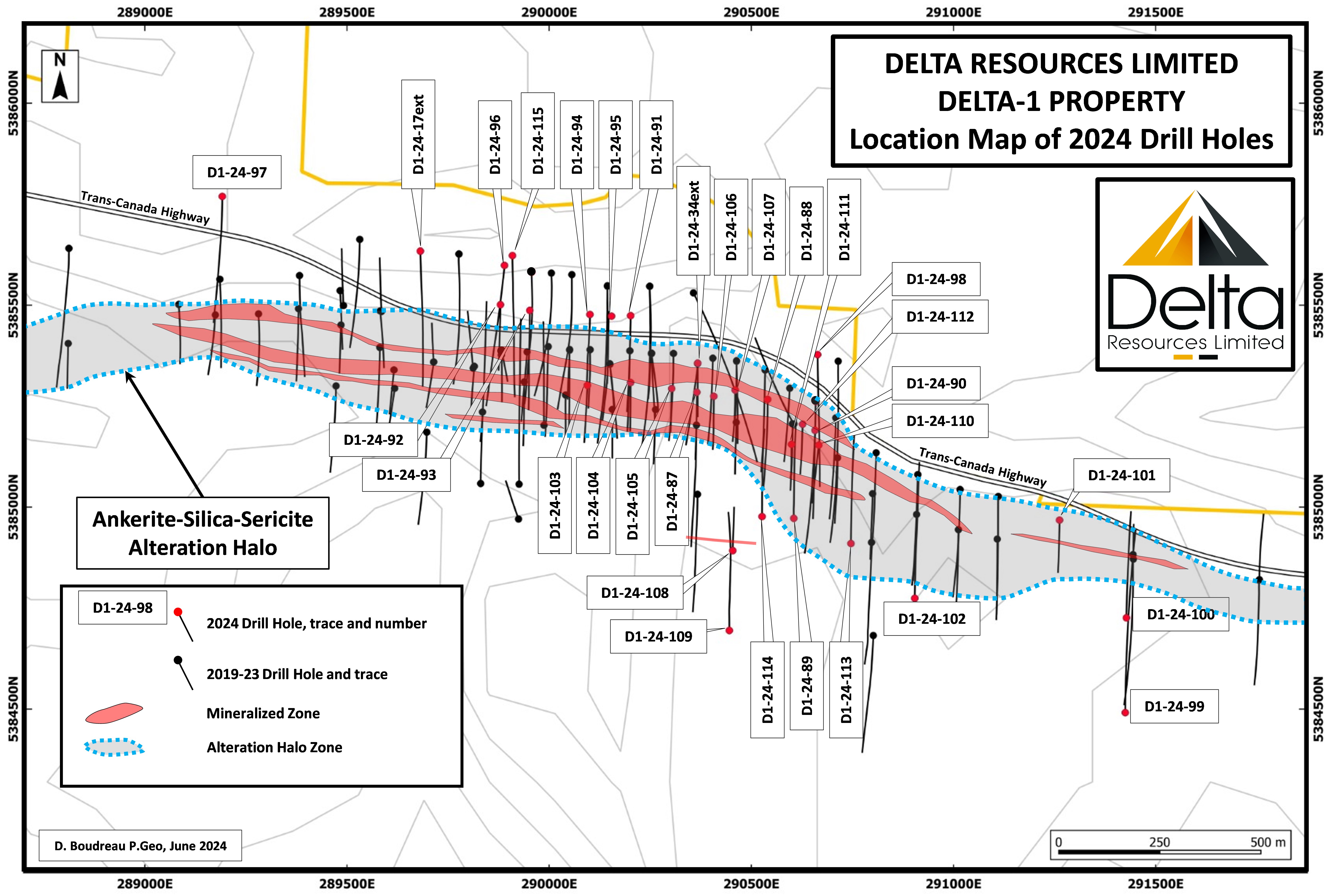
TABLE 11: Complete table of results at the Delta-1 Project in 2024 to date.
| DRILL HOLE NO | Easting | Northing | Elevation (m) | Azimuth | Incl. | Length (m) | FROM (m) | TO (m) | Au Grade (g/t) | CORE LENGTH (m) |
| (UTM Zone 16) | ||||||||||
| D1-24-34* | 290368 | 5385357 | 449 | 180 | -70 | 344.3 | 33.00 | 196.00 | 0.76 | 163.00 |
| incl. | 33.00 | 75.50 | 1.31 | 42.50 | ||||||
| incl. | 33.00 | 45.00 | 2.08 | 12.00 | ||||||
| incl. | 115.50 | 142.00 | 1.11 | 26.50 | ||||||
| incl. | 150.00 | 171.00 | 1.09 | 21.00 | ||||||
| 217.00 | 224.10 | 1.17 | 7.10 | |||||||
| D1-24-87 | 290363 | 5385284 | 455 | 180 | 45 | 222 | 35.30 | 45.80 | 1.66 | 10.50 |
| incl. | 41.70 | 45.80 | 3.63 | 4.10 | ||||||
| 65.50 | 70.90 | 1.23 | 5.40 | |||||||
| 102.50 | 121.00 | 0.37 | 18.50 | |||||||
| 192.00 | 192.80 | 22.30 | 0.80 | |||||||
| D1-24-88 | 290539 | 5385267 | 443 | 180 | 45 | 294 | 114.00 | 126.20 | 1.05 | 12.20 |
| incl. | 125.30 | 126.20 | 7.24 | 0.90 | ||||||
| D1-24-89 | 290599.02 | 5384971.8 | 455 | 0 | 45 | 348 | 169.50 | 171.00 | 4.31 | 1.50 |
| 199.90 | 216.00 | 1.03 | 16.10 | |||||||
| incl. | 215.00 | 216.00 | 9.40 | 1.00 | ||||||
| 276.00 | 282.00 | 1.05 | 6.00 | |||||||
| 294.00 | 313.00 | 0.42 | 19.00 | |||||||
| D1-24-90 | 290658 | 5385194 | 445 | 180 | 45 | 300 | 106.00 | 109.00 | 1.38 | 3.00 |
| 113.00 | 123.00 | 15.94 | 10.00 | |||||||
| incl. | 113.80 | 114.80 | 57.80 | 1.00 | ||||||
| incl. | 120.20 | 121.10 | 99.40 | 0.90 | ||||||
| 132.40 | 143.50 | 0.64 | 11.10 | |||||||
| 212.50 | 218.30 | 1.60 | 5.80 | |||||||
| D1-24-91 | 290200 | 5385472 | 435 | 180 | 45 | 333 | 236.90 | 246.00 | 1.26 | 9.10 |
| D1-24-92 | 289882 | 5385500 | 433 | 180 | 45 | 228 | 146.80 | 153.00 | 1.42 | 6.20 |
| D1-24-93 | 289956 | 5385490 | 429 | 180 | 48 | 369 | 113.70 | 116.50 | 1.62 | 2.80 |
| 262.10 | 267.50 | 2.39 | 5.40 | |||||||
| incl. | 263.10 | 266.30 | 3.71 | 3.20 | ||||||
| 328.00 | 332.60 | 1.33 | 4.60 | |||||||
| D1-24-94 | 290101 | 5385475 | 434 | 180 | 48 | 270 | 196.00 | 239.00 | 0.64 | 43.00 |
| incl. | 199.10 | 232.50 | 0.72 | 33.40 | ||||||
| 259.00 | 267.50 | 0.68 | 8.50 | |||||||
| D1-24-95 | 290155 | 5385476 | 437 | 180 | 43 | 264 | 56.60 | 81.50 | 0.76 | 24.90 |
| 99.25 | 106.90 | 0.85 | 7.65 | |||||||
| 143.00 | 157.00 | 0.43 | 14.00 | |||||||
| 165.90 | 167.00 | 3.67 | 1.10 | |||||||
| 181.00 | 190.00 | 1.68 | 9.00 | |||||||
| incl. | 181.00 | 182.00 | 11.50 | 1.00 | ||||||
| 205.30 | 242.10 | 1.08 | 36.80 | |||||||
| incl. | 205.30 | 229.40 | 1.42 | 24.10 | ||||||
| D1-24-96 | 289886 | 5385598 | 427 | 182 | 45 | 474 | 225.10 | 242.60 | 0.36 | 17.50 |
| 358.50 | 388.00 | 1.64 | 29.50 | |||||||
| incl. | 384.50 | 388.00 | 7.46 | 3.50 | ||||||
| D1-24-17ext | 289682 | 5385634 | 421 | 180 | 44 | 103.6 | 389.60 | 407.00 | 0.87 | 17.40 |
| incl. | 395.00 | 407.00 | 1.18 | 12.00 | ||||||
| and | 399.00 | 401.20 | 3.16 | 2.20 | ||||||
| D1-24-97 | 289190 | 5385772 | 422 | 180 | 45 | 420 | NSR | |||
| D1-24-98 | 290663 | 5385378 | 432 | 180 | 45 | 459 | 218.50 | 220.00 | 7.43 | 1.50 |
| 233.50 | 252.60 | 1.01 | 19.10 | |||||||
| incl. | 244.00 | 247.00 | 4.58 | 3.00 | ||||||
| 279.00 | 289.00 | 0.66 | 11.10 | |||||||
| 372.00 | 378.00 | 0.67 | 6.00 | |||||||
| D1-24-99 | 291427 | 5384496 | 452 | 0 | 45 | 603 | NSR | |||
| D1-24-100 | 291427 | 5384725 | 460 | 0 | 45 | 351 | 182.70 | 198.00 | 0.49 | 15.30 |
| D1-24-101 | 291265 | 5384994 | 443 | 180 | 45 | 177 | 102.00 | 116.00 | 0.64 | 14.00 |
| D1-24-102 | 290903 | 5384770 | 452 | 0 | 45 | 473.3 | NSR | |||
| D1-24-103 | 290101 | 5385305 | 447 | 180 | 60 | 267 | 10.90 | 19.40 | 0.33 | 8.50 |
| 31.20 | 48.00 | 0.45 | 16.80 | |||||||
| D1-24-104 | 290200 | 5385302 | 452 | 180 | 45 | 168 | 4.50 | 15.00 | 0.97 | 10.50 |
| incl. | 4.50 | 8.40 | 2.04 | 3.90 | ||||||
| 45.50 | 56.40 | 0.67 | 10.90 | |||||||
| incl. | 45.50 | 50.50 | 1.11 | 5.00 | ||||||
| 97.30 | 102.50 | 0.66 | 5.20 | |||||||
| 138.50 | 144.00 | 0.91 | 5.50 | |||||||
| D1-24-105 | 290308 | 5385296 | 454 | 180 | 45 | 150 | 7.80 | 46.00 | 0.32 | 38.20 |
| 98.50 | 106.50 | 0.71 | 8.00 | |||||||
| 132.80 | 140.50 | 0.59 | 7.70 | |||||||
| D1-24-106 | 290405 | 5385284 | 456 | 180 | 45 | 459 | 52.70 | 90.00 | 0.53 | 37.30 |
| incl. | 64.00 | 77.30 | 0.85 | 13.30 | ||||||
| 104.00 | 126.00 | 1.24 | 22.00 | |||||||
| D1-24-107 | 290464 | 5385291 | 447 | 180 | 45 | 174 | 21.00 | 21.80 | 26.50 | 0.80 |
| 62.00 | 67.10 | 0.44 | 5.10 | |||||||
| 115.70 | 124.50 | 0.67 | 8.80 | |||||||
| 153.00 | 165.80 | 0.60 | 12.80 | |||||||
| D1-24-108 | 290450 | 5384900 | 463 | 0 | 45 | 150 | 30.00 | 31.30 | 6.25 | 1.30 |
| D1-24-109 | 290450 | 5384700 | 468 | 0 | 45 | 399 | 228.00 | 228.80 | 11.40 | 0.80 |
| D1-24-110 | 290666 | 5385154 | 446 | 185 | 45 | 201 | 144.40 | 150.80 | 0.44 | 6.40 |
| D1-24-111 | 290600 | 5385155 | 448 | 180 | 45 | 102 | 16.00 | 36.30 | 0.44 | 20.30 |
| D1-24-112 | 290630 | 5385200 | 443 | 180 | 45 | 171 | 59.00 | 87.00 | 0.94 | 28.00 |
| incl. | 66.00 | 79.20 | 1.56 | 13.20 | ||||||
| 97.00 | 110.00 | 0.48 | 13.00 | |||||||
| 119.00 | 120.00 | 3.51 | 1.00 | |||||||
| 127.00 | 128.00 | 9.24 | 1.00 | |||||||
| D1-24-113 | 290747 | 5384911 | 452 | 0 | 45 | 372 | 129.00 | 136.00 | 0.43 | 7.00 |
| 184.00 | 192.50 | 0.53 | 8.50 | |||||||
| 308.00 | 315.70 | 0.36 | 7.70 | |||||||
| 328.90 | 341.70 | 0.53 | 12.80 | |||||||
| D1-24-114 | 290527 | 5384496 | 452 | 0 | 55 | 372 | NSR | |||
| D1-24-115 | 289910 | 5385623 | 428 | 180 | 55 | 549 | 258.90 | 270.00 | 0.46 | 11.10 |
| incl. | 263.00 | 270.00 | 0.60 | 7.00 | ||||||
Discussion of Results
Drilling within the previously defined gold mineralized zone: From 2019 to 2023, Delta drilled on widely spaced centres (generally 100m spacing) and defined a two (2) kilometre long gold zone from surface to 250 metres vertical. The 2024 drill holes continue to confirm the continuity of the mineralization within the mineralized envelope previously defined with widely spaced drilling from 2019 and 2023.
Eastern Expansion: The results of drill holes D1-24-101 and D1-24-100 returned the highest-grade and widest gold mineralization so far in the “Deep Blue” target within strongly altered volcanics and conglomerates. Albeit at a lower grade for now, the intersections effectively extend the gold mineralized zone to a strike length of 2.5 kilometres with a short hiatus at drill holes D1-23-49 and 50. The area will need more drilling to prove the untapped potential of the area.
New South Zone: Drill holes D1-24-108 and D1-24-109 were designed to test a south-dipping resistivity anomaly approximately 300 metres south of the Eureka zone. The two holes intersected high grade mineralization over narrow widths in silica replacement and magnetite zones. The two holes were drilled on the same section with the zone correlated over 140 metres down-dip. In 2023, drill hole D1-23-55 intersected the same horizon 100 metres to the west, returning 2.63 g/t Au over 1.0 metre. This new zone will need additional drilling and may provide a high-grade gold zone that would complement the Main Mineralized Zone.
Depth Extension: Three holes drilled at depth have intersected the strongly altered zone at depths of up to 300 metres vertical. Two of the drill holes are well mineralized with intercepts of 1.18 g/t gold over 12.0 metres and 7.46 g/t over 3.5 metres in drill holes D1-24-17ext and D1-24-96 respectively
Additional dtill slides accompanying the June 27th release of assays can be found in the link below.
During the Summer months Delta performed a Till sampling survey that consisted of a series of sampling fences spaced at every 1-1.2 km, oriented orthogonal to the dominant local ice-flow direction (here E-W to WNW-ESE). Samples within each fence are spaced by approximately 300 metres. The survey covered an area of roughly 80 km2 and consists of 224 sample sites.
The goal of the 2024 sampling program was to complement and expand on a previous surveys carried out in 2020 (see press release August 12, 2020). The 2020 till survey was highlighted by anomalous gold-grain counts that helped define the footprint of the Eureka zone prior to Delta’s 2021 and 2022 drilling programs and helped in the discovery of the Delta-1 Gold deposit.
Additionally, The company continued their agressive approach to land aquisition by doubling their land package.
The expansive property consists of 443 claim units spanning over seven (7) townships and covering over 93 square kilometres. Delta’s land package now covers over 306 square-kilometres in the central portion of the Shebandowan Greenstone Belt. The property now covers a 35-kilometre strike extent of both the Shebandowan and Gold Creek deformation zones. Both structures are gold-endowed, crustal-scale structural zones at the unconformable boundary between Temiskaming-Type sedimentary rocks and volcanic rocks of the Greenwater Formation; the same geological setting as Delta’s Eureka Gold Zone.
Figure 36: Property Expantion August 6th
With this aquisition, Delta holds a significant land package with high potential for multiple deposits, not only for gold mineralization, but also for magmatic copper-nickel deposits such as in the former producing Inco Mine.
History of the Shebandowan Greenstone Belt (The Inco Mines contribution)
The past-producing Inco Shebandowan Cu-Ni-PGE mine is located immediately north of the Delta-1 Project area. Between 1972 and 1998, Inco mined 9.29 million tonnes at an average grade of 1.75% Ni, 0.88% Cu and 1.83 g/t PGE and during that period, Inco had a stronghold on the belt. The Shebandowan Belt had a reputation as a Copper-Nickel Belt with little attention paid to Gold exploration.
Between late-1987 and 1990, Inco Gold, a subsidiary of Inco, carried-out limited grassroots gold exploration in the Shebandowan Belt and tested a number of areas with shallow drilling, including the I Zone, the South Zone and the Kukkee occurrence. Those gold occurrences were all abandoned by Inco when the Inco Gold Division was merged with Consolidated TVX.
Summer exploration program
Over the course of the 2024 summer exploration program, Delta was able to expose an eleven (11) metre section of the Eureka Gold Deposit at surface through mechanical trenching
The exposed section is located above the trace of drill holes D1-23-60 (1.79 g/t Au over 128.5 m), where overburden thickness was estimated to be manageable for excavators. The overburden thickness varied between 2.5 and 3.0 metres and the trench was halted when the thickness exceeded 3.0 metres. In all, the trench exposed a total of 11 metres of the zone across strike. A channel 4 cm wide was cut with a rock saw, averaging 8 cm deep for sampling. The zone was divided in 11 equal samples of 1 metre in length and sent to assay. The complete eleven metres of channel samples returned an average grade of 1.23 g/t Au.
Although the drilling data already clearly indicated that the mineralization is present at surface, this new trench provided Delta’s geologists with enhanced geological and structural information.
Additional work was also done in identifying various mineralized zones across the now expanded Land Package in the following areas which have historical results.
Figure 37: Geological map of the Shebandowan Belt showing Delta’s newly acquired property package covering 30,600 hectares. Temiskaming-type sediments are shown in yellow and prospective faults are shown as dotted black lines.
Delta acquired properties where it identified areas within the Shebandowan Greenstone Belt with similar geological setting as the Eureka Gold Deposit. These areas consist of fault bounded basins where shear zones unconformably juxtapose Temiskaming-Type sedimentary rocks of the Shebandowan Formation and volcanic rocks of the Greenwater Formation. These shear zones include (amongst others) the Gold Creek and Crayfish deformation zones which are gold-endowed crustal-scale structures thatinclude the newly acquired I-Zone and South Zone, and the Kukkee, AA, T1 and Moose Calf gold occurrences.
An interactive map which can be found at www.deltaresources.ca. which provides additional information about all the newly added properties acquired by Delta as well as selected gold occurrences.
During this phase of exploration is when the team brought Insidexploration out to the site to document the work being done in various zones. Below are a few of those identified areas along with historical work overviews and the associated content created.
The I-Zone
The I-Zone is located approximately 19 kilometres southwest of the Eureka Gold Deposit well within the Delta-1 Expanded property. The I-Zone is one of many similar significant gold occurrences in an area spanning 3.5 kilometres in strike and 1.2 kilometres in width. The mineralized dikes are hosted within a fault-bounded basin of clastic sediments (Temiskaming-type) lying unconformably over older volcano-sedimentary rocks of the Shebandowan Belt. The zone is located adjacent to the unconformity; a geological setting similar to that of the Eureka Gold Deposit.
Between 1988 and 1989, Inco Gold reported a drill intercept of 3.28 g/t Au over 14.6 metres at the I-Zone. Inco Gold also tested gold recoveries during that period with bulk cyanide tests yielding 96.2%.
From 1995 to 1997, Landore Resources followed Inco Gold’s exploration at the I-Zone and reported drill intercepts that included the following:
In 2008, Mengold Resources collected a 1000 kg mini bulk sample which yielded an average grade of 9.9 g/t Au.
The South Zone
Between 1988 and 1989, Inco Gold also drill tested the South Zone where it intersected the following results:
Also at the South Zone, in 2008, Mengold Resources reported a grab sample yielding 293.2 g/t Au, 1090 g/t Ag, 0.81% Pb and 0.07% Cu suggesting the potential for a Polymetallic Gold-Rich mineralization.
The Kukkee Occurrence
Inco Gold also drill tested the Kukkee Zone which included a drill intercept of 1.15 g/t over 15.47 m. and a grab sample of up to 44.5 g/t Au.
These structures are gold endowed and span an area of over a 20 km. Much of the area remains unexplored and untested.
T1 Zone
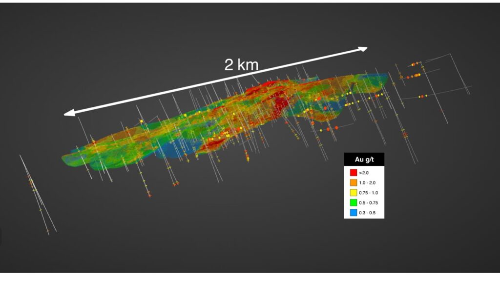
During the fall, Delta focused on doing an extensive data compilation of drilling on the Eureka deposit allowing them to develope a new 3d block model of the deposit with over 2 kms of strike (Figure 38).
Figure 38: Isometric view of the 3D Block Model looking down and towards the NNE. Since the 2023 Block Model, nearly 10,000 metres of additional drilling has expanded the deposit to a depth of 300 metres and 2.5 kilometres of strike length.
Additionally, Delta completed their land aquisitions for the year by adding The Orebot property, which consists of 39 claim units covering 743 hectares, in two blocks that are contiguous with the newly expanded Delta-1 property. The eastern block of the newly acquired property extends the coverage of the Shebandowan Structural Zone for nearly four (4) kilometres of strike to the east and brings the eastern boundary of the Delta-1 Expansion property to within three (3) kilometres of the Tower Gold Zone. The south block of the property covers a polymetallic occurrence where historical grab samples returned 2.1% nickel and 1.2% copper, and Inco Gold reported grab samples of 116 g/t Au and 175 g/t Au in 1988 (Ontario Ministry of Mines, Mineral Deposit Inventory MDI000000001398).
Figure 39: Map showing the Delta-1 Expanded Property and the location of Orebot Claims.
The other deal was to aquire eleven (11) claims from Metals Creek Resources Corp (“MEK”) (TSX-V: MEK) and the right to earn a 100% interest in an additional eight (8) claims held by Gold Cache Inc. (“GC”) by assuming an underlying agreement between MEK and GC. The combined claims cover approximate 233 hectares and are all contiguous with the newly expanded Delta-1 Property (see map below).
The claims located west of the Eureka Gold Deposit host a number of gold occurrences including the Echo Zone (1.04 g/t Au over 18.7m surface channel sample and 0.45 g/t Au over 21 m in drill hole), the Gold Cache Main Zone (29.4 g/t Au over 0.6m surface channel sample) and other surface grab samples ranging from 4.16 g/t Au to 50.1 g/t Au.
Figure 40: Map showing the Delta-1 Expanded Property and the location of the newly aquired claims.
Simultaneaously, the company raised $5,000,000 dollars in a charity flow through financing and aquired the permitting necessary for the newly expanded Delta property allowing the team to begin trenching and surface sampling in advance of a broader drill campaign.
On December 17th, Delta announced results from the I-zone from a channel sample program in close proximity to previous work done on the property. (For reference to historic grades and video see I Zone section above)
Two parallel channel samples were taken in a 5-metre wide dike known as the “I-Zone”, adjacent to channel samples taken by Inco Gold in 1988-89 for which results were left unreported. The channel samples tested the complete length of the exposed dike. Channels were cut perpendicularly to quartz-carbonate-pyrite veins and veinlets but parallel to the dike contacts (Figure 1). Results from the two channel samples are as follows:
Figure 41: Geological map of the I-Zone and location of the channel samples.

On January 15th, mobilized the drill rig to begin the first phase of drilling with a focus entirely on the Eureka Gold Deposit and adjacent targets. The primary objectives of the drilling were to significantly expand the gold inventory at Eureka, to improve the understanding of the controls on the gold mineralization and refine the geometry of the deposit. New targets were also identified in the immediate vicinity of the deposit which the team plans to drill. These new targets were defined through till geochemistry and whole rock geochemistry from surface samples. Additional Geophysical Induced Polarization (IP) surveys were also announced to be completed on these targets as drilling got underway.
Up to this campaign Delta had completed a total of 115 drill holes to date, totaling approximately 36,000 metres at the Delta-1 Gold project which include the exploration drill holes that preceded the discovery of the Eureka Gold Deposit. Prior to this campaign, gold mineralization been intersected on strike for over 2.5 kilometres, from surface to 300 metres vertical depth, and with a true width of up to 150 metres.
Between January and April 2025, Delta completed twelve (12) drill holes at the Eureka Gold Deposit, for a total of 5,909.80 metres, before drilling was paused for spring breakup and to evaluate the current impact of the expanded gold mineralization footprint at Eureka.
HIGHLIGHTS:
The twelve (12) drill holes of the program discussed below were testing specific targets with the objective of adding to the current gold inventory at Eureka (see figures 42,43 and 44). The targets include:
Figure 42: Longitudinal section of the Eureka Gold Deposit showing the targets tested during Delta’s initial drilling phase of 2025. The targets were all meant to expand the gold inventory at Eureka.

Figure 43: Longitudinal section of the Eureka Gold Deposit showing the drill results of Delta’s initial drilling phase of 2025. The 0.3 g/t gold contour is shown as a semi-transparent shell so all drill hole traces can be seen. Note that the South Horizon Target is not shown on this section, but is shown in map view at Figure 3.

Figure 44: Map view of the Eureka Gold Deposit showing the location and assay results of drill holes D1-25-123 and 124. Drill hole D1-25-123 was targeting the South Horizon, located some 200 metres south of the main deposit while drill hole D1-25-124 was aimed at the western extension of the deposit with a 600-metre step-out. Both drill holes intersected gold mineralization of the same style as the Eureka deposit, opening enormous potential in these areas.

Discussion of Results
West Extension Target: Drill hole D1-25-124 was aimed at an Induced Polarization target showing the west extension of the Eureka Deposit. The drill hole is located 600 metres away from known mineralization at Eureka and returned 0.44 g/t Au over 11.9 metres. This new intercept of Eureka-Style gold mineralization extends the known mineralization to a strike length of 3 kilometres and opens enormous potential to extend the deposit for 600 metres and beyond.
West Rake Target: Drill Holes D1-25-125 and D1-25-126 were aimed at the down-plunge extension of an interpreted west-plunging rake of the gold mineralization in the western portion of the deposit. Both drill holes intercepted two mineralized zones, confirming the interpretation with gold grades that appear to improve at depth. Drill holes D1-25-125 intercepted 0.49 g/t Au over 13.0 metres and 0.70 g/t Au over 35.5 metres including an intercept of 1.17 g/t Au over 17.5 metres. Drill hole D1-25-126 intercepted 1.19 g/t Au over 15.5 metres and 0.30 g/t Au over 17.0 metres.
Central Gap Target: Drill holes D1-25-116 and D1-25-127 were aimed at filling a large gap in the drilling in the western portion of the deposit as drill holes in the area had been drilled in 2019 and 2021. The drill holes intersected three (3) gold zones in sedimentary rocks, therefore filling the gap with gold mineralization that will increase the gold inventory at Eureka. Drill hole D1-25-116 intersected 0.57 g/t gold over 39.5 metres, 0.60 g/t gold over 15.5 metres and 0.44 g/t gold over 6.2 metres. Drill hole D1-25-127 intersected 0.57 g/t gold over 39.5 metres, 0.60 g/t gold over 15.5 metres and 0.44 g/t gold over 6.2 metres.
Main Rake Target: Drill Holes D1-25-117, D1-25-119a and D1-25-122 were aimed at the down-plunge extension of an interpreted west-plunging rake of the gold mineralization in the central portion of the deposit, at vertical depths of 400-550 metres. Drill hole D1-25-117 extended the main rake by approximately 200 metres down-plunge, intersecting the gold mineralization at a vertical depth of over 400 metres. The drill hole intersected over 150 metres of the alteration corridor in sedimentary rocks and feldspar-phyric dikes. Specks of visible gold were observed and two mineralized zones are reported grading 0.72 g/t Au over 4.5 metres and 0.62 g/t Au over 23.8 metres. Drill hole D1-25-122 extended the main rake down-dip by approximately 140 metres, also intersecting the gold mineralization at a vertical depth of over 400 metres. The drill hole intersected three mineralized zones grading 0.52 g/t Au over 16.7 metres, 0.35 g/t Au over 13.5 metres and 1.33 g/t Au over 9.0 metres. Drill hole D1-25-119A was aimed at extending the gold mineralization at a vertical depth of over 550 metres; 250 metres deeper than the known gold mineralization to date. The hole intersected sporadic, highly anomalous gold values over 194 metres, associated with a highly altered dike swarm, with gold assays ranging between 0.1 to 1.33 g/t Au. This is extremely encouraging as it shows the strongly altered mineralized corridor persisting at a vertical depth of 550 metres, demonstrating the strength and size of the mineralized system with the potential to host high-grade gold mineralization.
Vein-32 Extension Target: Drill Hole D1-25-118A was aimed at extending an intercept from drill hole D1-23-32 where a 4.5 m wide quartz vein and alteration returned 2.62 g/t gold over 9.0 metres. Although drill hole 118A did not intersect the quartz vein, a wide zone of alteration and mineralization was intersected some 70 metres to the east, grading 0.53 g/t gold over 26.3 metres. A second zone was also intersected grading 0.74 g/t Au over 7.5 metres.
Deep Volcanics Target: Drill Hole D1-25-120 attempted to drill sub-parallel to the unconformity to intersect mafic volcanics at depth. Despite several narrow, mineralized intervals and broad alteration zones, the main mineralized zone was missed. Assays nevertheless returned 0.41 g/t Au over 9.0 metres, 0.38 g/t Au over 5.0 metres and 2.9 g/t Au over 2.9 metres.
South Horizon Target: Drill Hole D1-25-123 was aimed at a new target that emerged from a mechanical trenching and sampling program that yielded assays of interest. The mineralized zone shows identical characteristics as the Eureka gold mineralization but is hosted by a diorite intrusion, a lithology that was previously thought to be unmineralized. Near-surface assays returned 0.84 g/t Au over 11.0 metres, including a section grading 1.02 g/t Au over 8.1 metres. The new zone is located approximately 250 metres south of the known Eureka deposit and may correlate with previous intercepts in drill holes D1-23-57 (1.39 g/t Au over 3.5 metres), D1-23-58 (1.34 g/t Au over 5.0 metres), D1-23-72 (1.31 g/t Au over 4.3 metres), D1-23-86 (1.45 g/t Au over 6.0 metres), D1-24-108 (6.25 g/t Au over 1.3 metres and D1-24-109 (11.4 g/t Au over 0.8 metres). If this interpretation is correct, this new zone is already defined and only sporadically tested, over a strike length of 1 kilometre. The zone is also open at depth and to the west.
To date, Delta has now completed a total of 127 drill holes for a total of 41,485 metres at the Delta-1 Gold Project since 2019, including the exploration drill holes that preceded the discovery of the Eureka Gold Deposit and gold mineralization has now been intersected on strike for over 3.0 kilometres, from surface to 400 metres vertical depth, and with a true width of up to 150 metres.
This section of the article will be updated quarterly to reflect any new developments
In closing, watch for steady newsflow throughout the summer as Delta continues to expand the footprint of the Eureka Gold Zone and begins exploration on the various new land acquisitions. The company is well financed and planning its next phase of exploration at Eureka and at the Delta-1 property. Work will include geological mapping, prospecting, sampling and mechanical trenching, followed by an additional phase of drilling. For more information on Delta Resources please visit www.deltaresources.com or https://insidexploration.com/dlta/
Disclosure
At the time of creation, Delta Resources is a client of Insidexploration Analytics Inc.
Disclaimer
Project Reports are under the Issuers editorial control and published on Insidexploration. Information contained in Project Reports may change over time and may differ from other sources. For more information, please reference www.deltaresources.ca for Corporate, Technical Information and Project Specifications for the latest public disclosures.
Further;
The information herein is meant for informational and entertainment purposes only and does not constitue a recommendation to buy or sell securities. While every effort is taken to ensure the accuracy of everything contained on this website, no warranty of same is expressed or implied. While we endeavour to keep the information up to date and correct, we make no representations or warranties of any kind, express or implied, about the completeness, accuracy, reliability, suitability or availability with respect to the website or the information, products, services, or related graphics contained on the website for any purpose. While every caution has been taken to provide readers with most accurate information, we recommend that you consult a registered investment professional in your jurisdiction before undertaking any investment in any asset whatsoever.
All Issuer content within this space is considered authored by the Company as an extension of their digital presence. All copyrights are retained by each respective creator(s).
REFERENCES:
– Bryant, J.G., 1972; Summary Report Geology, Dawson Road Lots Property, Thunder Bay District, Ontario., for Getty Mines Limited., 12p. 2 maps.
– Girard, R. and Burden, D., 2021; Glacial Sediments sampling program, Delta-1 project – Shebandowan Area, Ontario., IOS Services Geoscientifiques, for Delta Resources Limited, 205p.
– Parker, D.P., 2003; Summary Report of Phase II Drilling, Wedge Project, Shabaqua Area – Shebandowan Belt, Thunder Bay District, Ontario., RJK Exploration Ltd., 62p.
– Puumala, M.A., Campbell, D.A., Tuomi, R.D., Pettigrew, T.K. and Hinz, S.L.K. 2018. Report of Activities 2017, Resident Geologist Program, Thunder Bay South Regional Resident Geologist Report: Thunder Bay South District; Ontario Geological Survey, Open File Report 6338, 101p.
– Tremblay, L., 2021; Description pétrographique d’un échantillon de sondage, Projet Delta-1., IOS Services Geoscientifiques, for Delta Resources Limited, 23p.
– Delta Resources Website, Delta-1 Project page – https://deltaresources.ca/delta-1/
– Delta Resources MD&A dated Nov 23 2021 which can be found on the company’s SEDAR Profile
– Delta News Releases – https://www.deltaresources.ca/news-releases/
– Reviewed, Edited and Approved by Delta Resources, CEO, Andre Tessier


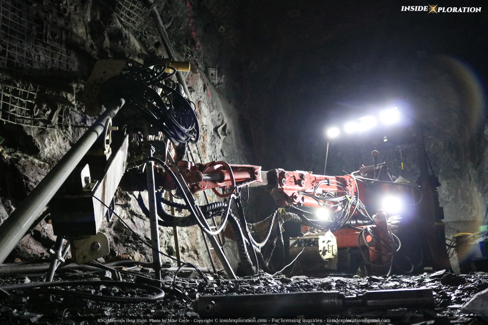
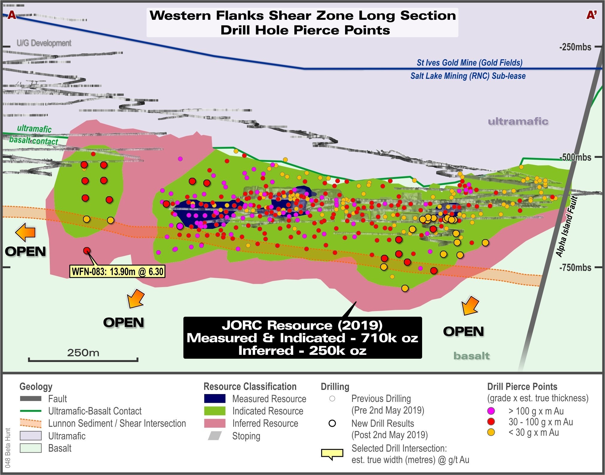