


Extended Research


Extended Research
- Trending
- Comments
- Latest

Avante Mining Corp. (TSXV: AVA) is a Canadian-based exploration company with a diversified portfolio of mineral projects in British Columbia and Labrador, Canada. With a primary focus on Battery Metals, the company has recently acquired a nickel project just 50 km north of the Voisey’s Bay mine, which boasts nickel grades in excess of 1%. This project will be the primary focus in 2023. The company also owns the LMSL Copper Gold & Silver Project in the Nicola Mining Division of British Columbia and is surrounded by and along trend with three major mining operations. This project underwent a full suite data analysis by Earthlabs (formerly known as “GoldSpot”), with permits in hand, LMSL is ready to be drilled. The third project held by Avante is the Blackdome Gold Project, an early-stage gold and silver property located in the Clinton Mining Division of British Columbia. This asset has good upside potential based on results from the sampling that has been done at surface. All three assets are located in mining-friendly jurisdictions and Avante is well-positioned to capture growth opportunities while building long-term shareholder value.

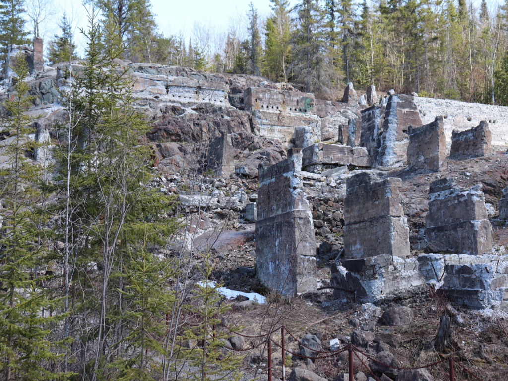
Blackdome is located in the Clinton Mining Division approximately 120 kilometres southwest of the City of Williams Lake in British Columbia, Canada. The project is comprised of six adjacent land claims covering a total of 3,479 hectares with potential to host multiple large mineralized epithermal gold and silver occurrences. The property is accessed by road to the north and south and by air via helicopter from either Lillooet or Williams Lake.
Proximal mining operations to the project include, The Bralorne Gold Camp to the Southeast which has produced over 4 million ounces of gold and is still currently in operation. New Prosperity to the Northwest has a resource of 5.3 billion pounds of copper and 13.3 million ounces of gold. Newton Lies north of Prosperity and has a 1.6 million ounce resource of gold defined.
The oldest rocks on the claims are grey to black, thinly bedded siltstone, argillite, and lesser greywacke of the Lower Cretaceous Taylor Creek Group (Unit Kt). These rocks are pyritic and hornfelsed and were intruded by feldspar porphyry dykes. To the west and south the Taylor Creek Group is unconformably overlain by the Upper Cretaceous Kingsvale Group, consisting of a sedimentary to volcaniclastic assemblage. The dominant structure on the claims are west to northwest trending, steep-angle normal faults which down-drop the Miocene basalts against the older feldspar porphyry dykes and sediments. Weaker, vertical to steep dipping faults and joints were noted on northeasterly and northerly trends. The three quartz veined bedrock locations were controlled by this vertical northeasterly (50 to 60 degree) trend. Gold-silver mineralization identified on the Blackdome property appears to be associated with intrusions that possibly served as a conduit for the hydrothermal mineralization.
This area was first explored in the 1980’s when Barrier reef resources staked the land to protect ground highlighted by silt sampling which contained anomalous gold and arsenic. Subsequently, the company carried out their own reconnaissance program which included soil and grab sampling along with some mapping on a 200m by 50m grid. The results showed large areas that contained anomalous gold (90ppb) and rock samples containing up to 2,000 ppb. These soil and rock anomalies were not followed up on until 1987 when the Dil 1 and 2 claims were staked by R. Durfeld of Williams Lake, B.C.
From 1987 to 1989 the area was worked as the DIL mineral claims. This work by way of grid preparation, prospecting, rock sampling and geological mapping which defined the quartz boulder trains with gold values of up to 19,320 ppb gold or 19.3 g/t Au and 35.4 g/t Ag.
Contract prospectors staked the Knight claims which encompassed the Dil 1 and Dil 2 claims on September 25, 1989. They immediately sent a team of prospectors with a mandate to focus their regional work towards the Dil Plateau area after recognizing proximal float trains and scattered boulders of banded, vuggy epithermal-type quartz. The Dil property was thought to have expired at the time of staking, however, assessment work was filed on the last day while Inco personnel were working in the field and this resulted in a large segment of ground being overstaked by the configuration of the Knight claim.
Work in 1990 by Inco Ltd. discovered two zones of gold mineralization including a pyritic, hydrothermally altered conglomerate occurrence known as the Knob Showing about 200 m inside the claim boundary. Individual high’ gold assays of between 0.745 g/t to 15.08 g/t Au (4 samples) were obtained from conglomeratic rocks displaying variable degrees of chalcedonic quartz micro fracturing, carbonate, limonite, clay, chlorite and pyrite alteration. One panel chip sample over a 1.2 x 0.5 metres area assayed 54.53 g/t Au.
In 1994 R.M Durfield relocated the area of interest and named them the Tante 1-8 mineral claims.In 1996 a Geochemical analysis was performed on nineteen soil samples, collected at 25 metre intervals on three lines. This sampling tested a small area of the east zone as lines 48+50 and 49+00 north and the anomalous soil site as line 52+00 east. Soils were collected as fine poorly developed rusty B-horizon clays between rock fragments at an average depth of .3 metres using a grub hoe. The results returned many anomalous values, greater than 100 ppb gold and up to 3 19 ppb, in this area of mineralized quartz vein float. The highest gold value is on line 52+00 E where there was no quartz vein float noted. The plots for arsenic and antimony suggest elevated values with the higher gold values.
In 2010, an outcrop sample (RHS-Dil-02) of sediments and feldspar porphyry hosting 10- to 15-centimetre wide banded quartz veins with trace to 2 per cent pyrite from the ‘East’ zone assayed 36.39 grams per tonne gold and 10.1 grams per tonne silver (Assessment Report 31814). Float samples (77908) from the East zone yielded up to 27.81 grams per tonne gold and 0.135 per cent molybdenum, whereas five samples of subcrop from the Legal zone yielded from 1 to 11 grams per tonne gold (Assessment Report 31814).
Avante Mining (formerly ArcPacific Resources Corp.) entered into an option agreement to acquire a 100% interest in the Blackdome Property on July 27th, 2020 after staking 5 claims contiguous to the property earlier in the year, bringing the project area to a total of 3,479 Hectares.
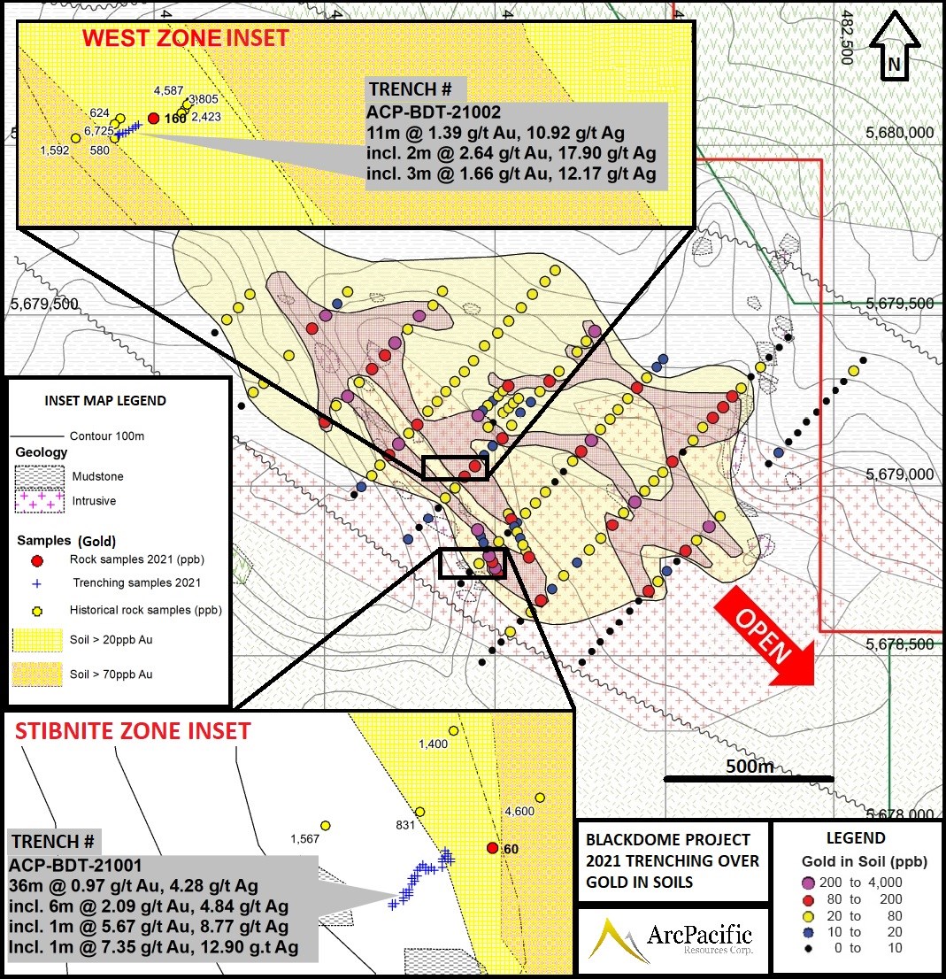
Two trenches were dug and sampled during the 2021 field season and the entire length of both trenches showed anomalous to high-grade gold and silver values. With the both trenches returning greater than 1 gram per tonne (“g/t”) gold equivalent (“AuEq”) (using gold and silver values only) over their entire lengths, and up to 7.35 g/t gold over a 1-meter segment. These results confirm epithermal-style gold-silver mineralization at the Property and indicate that it is likely responsible for the 1 by 2-kilometre gold-in-soil anomaly (see Figure 1 below). Geochemical evidence (including elevated antimony, arsenic and mercury) also suggests that the level of exposure is at a high level within the epithermal system, leaving significant potential for the entire extent of the precious metal or gold rich portion of the system to be intact.
Highlights
Table 1: Blackdome Epithermal Au-Ag – 2021 Trenching Results (1-4)
| Table 1: Blackdome Epithermal Au-Ag – 2021 Trenching Results (1-4) | ||||||||
| Trench | Zone | From (m) | To (m) | Interval (m) | g/t Au (Gold) | g/t Ag (Silver) | g/t AuEq 3, (Au+Ag Only) | % Sb 4 (Antimony) |
| ACP-BDT-21001 | Stibnite Zone | 0.00 | 36.00 | 36.00** | 0.97 | 4.28 | 1.03 | 0.21 |
| Incl. | 0.00 | 3.00 | 3.00 | 1.46 | 14.68 | 1.66 | 0.09 | |
| Incl. | 21.00 | 30.00 | 9.00 | 2.39 | 5.85 | 2.47 | 0.28 | |
| and Incl. | 22.00 | 23.00 | 1.00 | 5.67 | 8.77 | 5.79 | 0.12 | |
| and Incl. | 25.00 | 27.00 | 2.00 | 2.74 | 4.95 | 2.81 | 0.1 | |
| and Incl. | 29.00 | 30.00 | 1.00 | 7.35 | 12.90 | 7.53 | 0.09 | |
| ACP-BDT-21002 | West Zone | 0.00 | 11.00 | 11.00** | 1.39 | 10.92 | 1.54 | 0.009 |
| Incl. | 0.00 | 2.00 | 2.00 | 2.64 | 17.90 | 2.89 | 0.01 | |
| 3.00 | 6.00 | 3.00 | 1.66 | 12.17 | 1.83 | 0.01 | ||
| ** Entire length of trench. 1) Gold Equivalent (Eq) was calculated with the following metal prices; Gold (Au) $1800/oz and Silver (Ag) $25/oz. All metals reported in USD and calculations do not consider metal recovery. 2) Intervals taken as chip samples along approximate mineralized trends; true widths are unknown at this time. 3) Antimony values are not included in the Gold Equivalent (AuEq). 4) Antimony values are capped at 1% due to sample values exceeding assay limitations of 1%. | ||||||||
| Table 2: Blackdome Epithermal Au-Ag – 2021 Select Rock Sample Results | |||||
| Sample No. | Easting | Northing | Sample Type | Gold (g/t) | Silver (g/t) |
| D365207 | 482209 | 5679779 | Float | 8.37 | 2.71 |
| D365253 | 481715 | 5679990 | Float | 8.23 | 27.7 |
| D365303 | 481097 | 5679382 | Float | 5.14 | 14.2 |
| D365235 | 482310 | 5678875 | Float | 2.05 | 7.03 |
| D365252 | 481469 | 5678715 | Float | 1.59 | 10.45 |
| D365225 | 482280 | 5679711 | Outcrop (grab) | 1.39 | 3.17 |
| D365302 | 481074 | 5679363 | Float | 1.36 | 23 |
| D365304 | 481105 | 5679384 | Float | 1.34 | 18.95 |
| D365224 | 482280 | 5679711 | Outcrop (grab) | 1.2 | 2.6 |
| D365248 | 481395 | 5678651 | Float | 0.98 | 24.1 |
| D365254 | 481576 | 5678825 | float | 0.88 | 28.6 |
| D365246 | 481700 | 5679079 | Float | 0.71 | 17.85 |
| D365245 | 481700 | 5679079 | Float | 0.68 | 0.8 |
| D365244 | 481700 | 5679079 | Float | 0.67 | 11.5 |
| D365251 | 481414 | 5678686 | Float | 0.57 | 1.06 |
| Projection in UTM NAD83 Z10. Total number of samples 79, average grade of all samples 0.49g/t Au. | |||||

Due to the limited scope of this initial program, only 2 of 6 known target areas were tested, and over 80% of the Property remains untested. Test pitting along the top of the ridge area was unsuccessful in reaching bedrock where historical float samples have run up to 19.3 g/t gold.
The elongated and unvegetated ridge is the center of the 1 by 2-kilometre open-ended gold in soil anomaly (shown above), where the next phase of planned work will require mechanical trenching or drilling to properly test the multiple target areas within this wide anomaly.

The hand trenching completed in this program represents the first trenching completed on the Property. Trenching locations were selected based on historic soil, grab and outcrop samples, where the historic samples include up to 54 grams per tonne gold in rocks and over 4 grams per tonne in soils. Based on the location of the float samples along the crest and margins of the broad ridge, it is probable that they are also locally derived.

The samples taken as part of the first-pass program (see table 2 above) were predominantly quartz and quartz carbonate vein material often displaying epithermal characteristics including crustiform, colloform, chalcedonic, banded, bladed, and vuggy textures and locally including up to 1% sulphides. Massive stibnite was also observed in 1-4-centimeter seams in quartz vein margins in the Stibnite Zone.

Substantial grades of antimony (often exceeding the assay limit of 1%) along with the elevated levels of arsenic indicate the epithermal system is exposed at a high level as shown in the Blackdome Geological Model above (see Figure 4). This model is based on a type-example of a Low Sulphidation (“LS”) epithermal system and suggests that that the best gold and silver grades are still located in a potential bonanza grade zone below and will need follow up drill testing as there is no record that the property has ever been drilled.
Updates will be provided as they occur
Disclosure
At the time of creation, Avante Mining is a client of Insidexploration Analytics Inc.
Disclaimer
Project Reports are under the Issuers editorial control and published on Insidexploration. Information contained in Project Reports may change over time and may differ from other sources. For more information, please reference https://avantemining.com/ for Corporate, Technical Information and Project Specifications for the latest public disclosures.
Further;
The information herein is meant for informational and entertainment purposes only and does not constitute a recommendation to buy or sell securities. While every effort is taken to ensure the accuracy of everything contained on this website, no warranty of same is expressed or implied. While we endeavor to keep the information up to date and correct, we make no representations or warranties of any kind, express or implied, about the completeness, accuracy, reliability, suitability or availability with respect to the website or the information, products, services, or related graphics contained on the website for any purpose. While every caution has been taken to provide readers with most accurate information, we recommend that you consult a registered investment professional in your jurisdiction before undertaking any investment in any asset whatsoever.
All Issuer content within this space is considered authored by the Company as an extension of their digital presence. All copyrights are retained by each respective creator(s).


