Avante Announces Acquisition of 1446199 B.C. LTD.
March 5, 2024
Ron Perry – The Dawn of A.I in Mining
April 13, 2023
Cobalt: Discovering the Mining History Of Northern Ontario
April 13, 2023
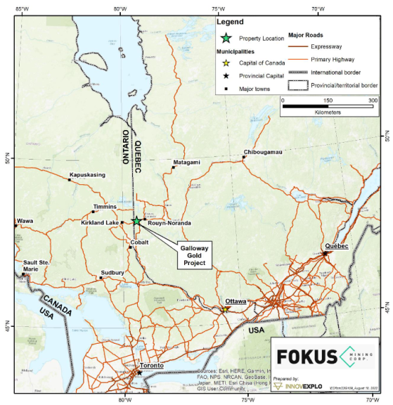
The Galloway Gold Project covers an area of approximately 2,865.54 hectares and is situated approximately 30 kilometers west of the mining town of Rouyn-Noranda (see Figure 1). The project is positioned within a region known for its prolific gold mining operations, making it a highly prospective area for gold exploration and development. The southern and eastern parts of the property lie immediately along and are partially transected by the highway. The central part of the property can be accessed via the paved Chemin des Pourvoiries Road, whereas the Chemin du Mont-Kanasuta road leads to the western part. The latter is paved as far as the Kanasuta Ski Centre but continues as a gravel road beyond that. While this road is not maintained, it is in good standing.

Introduction – A brief description of the company and assets.
Regional Geology & Mineralization – Discussing the Regional geology and styles of mineralization in the Abitibi Greenstone belt and the various mining operations that have been developed across it.
Localized Geology & Mineralization – Localized geology and deposit models on the Galloway Gold Project
Project History – The history of the Galloway Gold Project and how it came together.
Current Exploration – Fokus Mining Exploration activities
Technical Report – Key information and a link to the recently filed Technical Report.
Conclusion – Summary of thoughts and most current activities.
The project is situated in the heart of the Abitibi Greenstone Belt, which is renowned for its world-class gold deposits. The region has a long history of mining and hosts several significant gold mines, including the Canadian Malartic mine and the Casa Berardi mine. The Abitibi greenstone belt lies in the southeastern Superior Province and is bounded by the Kapuskasing Structural Zone to the west, the high-grade metamorphic Opatica Subprovince to the north, the Paleoproterozoic Grenville Province to the east- southeast, and the Archean metasedimentary Pontiac Subprovince to the south. The Abitibi greenstone belt comprises six metavolcanic and two metasedimentary assemblages intruded by syn-volcanic to post-tectonic intrusions, and its evolution spans approximately 125 million years between 2795 Ma and 2670 Ma.
The volcanic and sedimentary packages in the region are generally separated by steep east-trending faults that are either tectonic in origin or superimposed by unconformities. Some of these faults, such as the Larder Lake– Cadillac Fault Zone (LLCFZ) and the Porcupine-Destor Fault Zone (PDFZ), and similar breaks in the northern Abitibi, transect the entire belt and display evidence of multiple overprinting ductile-brittle deformation events, including early thrusting and later strike- slip and extension movements. A series of pre-Timiskaming, early- to syn-Timiskaming and post-Timiskaming intrusions were emplaced at various stages of the sedimentary and tectonic evolution. The metamorphic grade varies between the southern and northern Abitibi greenstone belt based on the volume of intrusive rocks and the variation of exposed crustal levels. Consequently, the metamorphic grade in the northern part of the belt ranges from greenschist to amphibolite facies, whereas the southern part displays prehnite-pumpellyite to lower greenschist facies metamorphism.
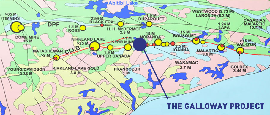
Over the past century, the Abitibi greenstone belt produced more than 6,100 t of gold (See figure 3) from four different auriferous deposit types: syn-volcanic gold-bearing sulphide lenses and sulphide veins; sulphide-rich Cu-Au-Ag veins; intrusion-associated stockwork- disseminations, veinlets, and replacements; and quartz-carbonate veins with the most important deposits concentrated along the LLCFZ and DPFZ. The stockwork style mineralization is associated with alkaline to subalkaline intrusions that were emplaced synchronously with the 2683 Ma to 2670 Ma Timiskaming sedimentation, whereas the vein-style mineralization coincides with 2660 Ma to 2640±10 Ma D3 deformation event. The quartz-carbonate vein-type mineralization accounts for approx. 60% of the total gold endowment in the region.
The Property is underlain by the mafic to felsic metavolcanic rocks of the Archean Blake River Assemblage (Duprat-Montbray Formation), the volcanic and metasedimentary rocks of the Timiskaming Assemblage, Archean syenitic and gabbroic intrusions as well as the unconformably overlying sedimentary rocks of the Paleoproterozoic Huronian Supergroup (Figure 4). The Property also extends up to 4.5 km north of the LLCFZ and other NE and NW trending brittle faults transect the Archean and Proterozoic rocks.
The metavolcanic rocks of the Duprat-Montbray Formation and, to a lesser extent, the Timiskaming metasedimentary rocks crop out in the northern and western parts of the Property, respectively. The southern part is characterized by sedimentary rocks of the Paleoproterozoic Cobalt Group unconformably deposited atop the Archean basement. Regionally, the Duprat-Montbray Formation consists of mafic to intermediate massive and pillowed flows and lesser felsic flows, but it is the predominantly andesitic and basaltic andesite flows of this formation that crop out on the Property. The Cobalt Group consists of a lower sequence of glacially-derived conglomerates succeeded by mudstone, siltstone and coarse arenite, with lesser chemical sedimentary rocks. The most important syenitic intrusion in the area is the 2682±1 Ma syn-tectonic Baie-Renault intrusive complex emplaced in the Blake River assemblage. The emplacement of the syenite predates or is broadly coeval with the deposition of the Timiskaming Assemblage represented by intercalated alkaline volcanic rocks in the westernmost part of the Property.
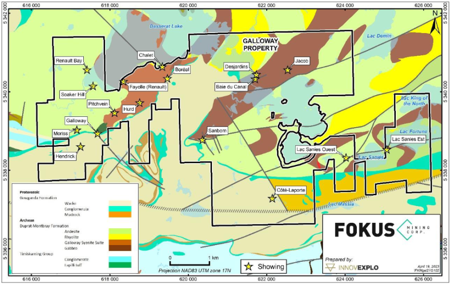
The Moriss Zone, which lies west of the GP deposit and was discovered by drilling in 2010, is hosted by breccia at the southern contact of a feldspar porphyry diorite (possible apophysis of the Baie-Renault intrusive complex) and a pillow basalt and a lapilli or block tuff (Kelly, 2012). The Galloway deposit and the Soaker Hill and Sanborn showings are hosted by the volcanic rocks of the Blake River Assemblage (Figure 4).
The main mineralization styles at Galloway correspond to the syenite-associated disseminated gold deposit type and magmatic-hydrothermal deposits of the porphyry type. These mineralization types are spatially and genetically associated with alkaline magmatism. The Cu-Au-(Mo) deposits and showings on the property are thought to be associated with the establishment of a magmatic-hydrothermal system centered on the Baie-Renault intrusive complex. Some showings are polymetallic with Cu-Au-Mo (Fayolle-Renault, Boréal, Hurd, Sanborn and Lac-Sanies showings), whereas others are exclusively auriferous (Pitchvein, Soaker Hill, Baie du Canal and Jacob). The Pitchvein, Hurd, Fayolle-Renault and Boréal showings are located in porphyritic syenite, whereas the Baie du Canal and Jacob showings are hosted by the Horseshoe dyke that is composed of gabbro, diorite and quartz diorite (See Figure 4).
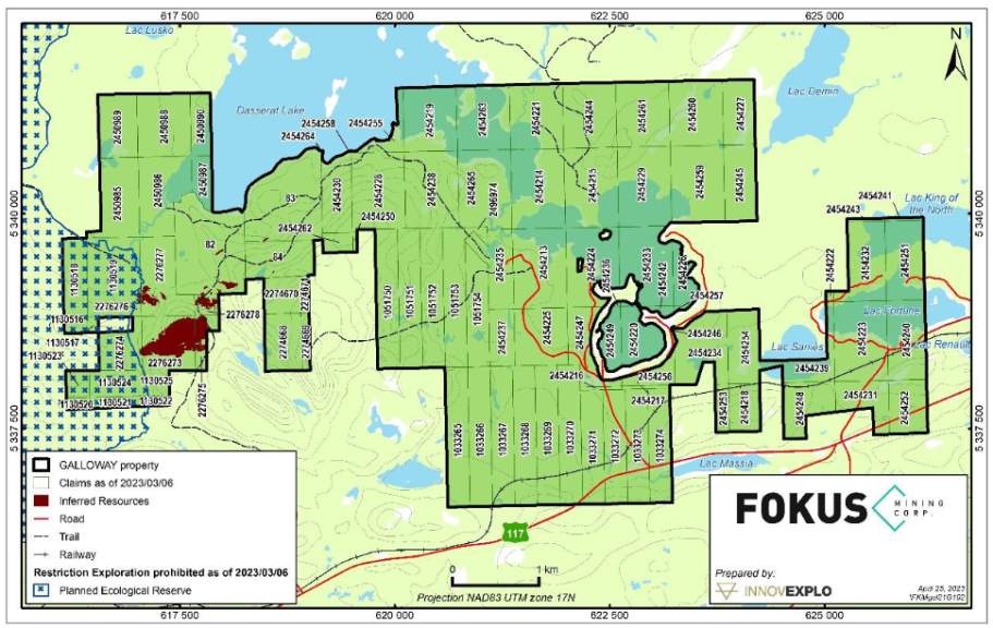
The history of gold in the Abitibi goes back to the early 1900’s when Alphonse Olier and Auguste Renault discovered the first gold on the east shore of Lac Fortune. However, the area only really became a “mining camp” after the world-class Horne deposit was discovered in 1922. The discovery on what is now the Galloway project would come several years later. However, to truly understand The Galloway Property one must understand that it was for most of its history, divided into eight (8) claim blocks. (See figure 5)
The Hurd Block has historically been the most active from an exploration point of view as it hosts the Galloway-Pitchvein (GP) Zone for which SRK estimated mineral resources in 2012. Most blocks have been subjected to geological and geochemical exploration work and unfortunately, many of those surveys are quite old and focused on minor showings. Their location is sometimes inaccurate, and reports are often incomplete with no assay results.
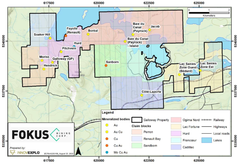
The Perron Block comprises 14 contiguous claims in the southwest corner of the Property (Figure 5). The area has no known surface exposures of mineralization. Sedimentary rocks of the Paleoproterozoic Cobalt Group underlie the southern half of the claim block. Very little past exploration was carried out on these claims, with only a few drill holes as summarized in Table 1.
Table 1 – Summary of the historical work on the Perron Block

Drilling
Historical exploration drilling on the claim block is summarized in Table 1.1
Table 1.1- Summary of historic drilling on the Perron Block

In 1994, Silver Century Explorations drilled one (1) DDH on the Perron Block that intersected volcanic rocks with sulfide mineralization and elevated Zn and Cu grade . In 2006, Pro-Spect-Or drilled one (1) hole (PSR-02-2006) in the area where elevated Au grades were encountered at depth in Archean volcanic rocks.
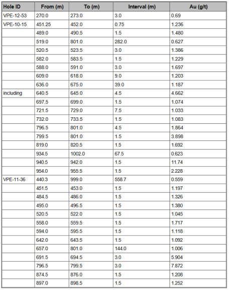
Between 2010 and 2012, Vantex drilled nine (9) DDHs, three (3) of which intersected appreciable Au grades summarized in Table 1.2
Table 1.2 – Summary of drill results (Hendricks Zone)

The 10 contiguous claims of the Cadillac Block lie in the south-central part of the Property (Figure 5). They are predominantly underlain by sedimentary rocks of the Cobalt Group. The area has no known surface exposures of mineralization. Table 2 summarizes the historical work on the claim block.
Table 2 – Summary of the historical work on the Cadillac Block

Drilling
Historical exploration drilling on the claim block is summarized in Table 2.1.
In 1939, Teck drilled seven (7) holes in the region, including two (2) holes on the Cadillac Block. Low-grade values were intercepted (Austin and Ross, 1939). In 1944-1945, Toburn Gold Mines drilled five (5) boreholes across the thick Paleoproterozoic unit, hoping to reach the Larder Lake– Cadillac Fault Zone (holes 12, 13, 14, 15, 21). No significant gold values were reported.
In 1984, Canamax drilled one hole (070-01-01) in the northern part of the claim block, but no significant Au values were obtained.
In 1986, Kerr Addison’s hole CLD-86-01 intersected a 4.3-m-thick grey quartz vein containing disseminated pyrite and fuchsite (ultramafic host?) from 864 to 871 m but returned low Au values. The vein is in contact with Timiskaming sedimentary rocks and a major fault. The hole also intersected 1.7 to 1.8 g/t Au over 0.75 m up-hole in the Timiskaming sedimentary rocks. The best intersections are presented in Table 2.2.
Table 2.1 – Summary of historical drilling on the Cadillac Block


In 1992, the Noranda Exploration Company drilled two (2) DDHs (OG-92-04 and OG-92-05). Drill hole OG-92-04 intersected carbonate-pyrite veins that returned 0.137 g/t Au over 2.7 m. Drill hole OG-92-05 intersected 1% pyrite in a 23-cm-wide carbonate-quartz vein that returned 0.355 g/t Au over 0.8 m and another strongly carbonate-altered interval that returned 0.408 g/t Au over 1.53 m (Table 2.2).
In 1994 and 1995, Silver Century drilled a few holes in which low Au values were intercepted. Of these, only one hole was on the claim block, but it did not intersect significant Au mineralization. In 1998, an “in-the-hole” IP anomaly was detected by Silver Century, but was not tested by further diamond drilling.
Table 2.2 – Summary of historical drilling on the Cadillac Block

The Sanborn Block consists of eight (8) contiguous claims in the central part of the Property (Figure 5). One (1) Cu-Au showing (Sanborn) crops out in the middle of the claim block. In the early 1950s, Violamac Mines Ltd. carried out several geophysical surveys followed by eight (8) drill holes. All the holes were shallow, with depths ranging from 14 m to 184 m (table 3).
Table 3 – Summary of the historic work on the Sanborn Block


Drilling
A fair amount of historical drilling has been completed on the block, as summarized in Table 3.1.
In the early 1950s, Violamac Mines Ltd carried out several geophysical surveys followed by eight (8) drill holes. The DDHs were all shallow, with depths ranging from 14 m to 184 m. The highest assays reached 0.047 g/t Au over 0.49 m. A 1957 government activity report indicates that Payrock Mines Limited drilled three (3) holes on the property. No significant result is reported.
In 1980, Dr. Sanborn drilled three (3) more holes in the southeastern portion of the claim block (F-1 to F-3). No significant gold results were reported.
Table 3.1 – Summary of historical drilling on the Sanborn Block


In 1981, the Sanborn Company drilled four (4) DDHs on the claim block (81-01 to 81- 04), but no Au grades were reported (Tagliamonte and Hallof, 1981). In 1982, Dr. Sanborn drilled three (3) additional holes (82-01 to 82-03) on the block. Pyrite- chalcopyrite-rich chloritic fractures returned 1.12% Cu and 0.31 g/t Au over 0.27 m in hole 82-02 (Stoch, 1982). Another interval intersecting calcite-cemented breccia with fragments containing up to 8% disseminated pyrite returned 2.18 g/t Au in hole 82-02. In 1987 and 1988, Kerr Addison drilled three (3) holes. Only two (2) gold-bearing intervals were intersected, as summarized in Table 3.2.
Table 3.2 – Best results from historical drilling on the Sanborn Block

The Ogima Nord claim block consists of 21 contiguous claims in the north-central part of the Property (Figure 5). Four (4) Au-Ag-Cu-Mo-showings are exposed on the block: Jacob (Au), Boréal (Au-Cu), Payrock (Au-Ag-W) and Payrock Island (Au-Ag-Cu-Mo). Various prospectors worked the area until 1983, and stripping, geological, geophysical surveys were performed for claim maintenance. Table 4 summarizes the historical work on the claim block.
Table 4 – Summary of the historical work on the Ogima Nord Block

Drilling
In 1957 and 1964, it was drilled by Payrock Mines (Island and Baie du Canal areas) but the released reports do not list any sampling or assay results. Up until 1983, the property was worked by various prospectors (Laporte, Côté and Rowe) and stripping, geological, geophysical surveys and shallow drilling were performed for claim maintenance.
In 1984 and 1985, Canamax completed a five (5) hole-drill program. Three (3) of these holes fell on the claim block. The results are summarized in Table 4.1.
Table 4.1 – Summary of historical drilling on the Ogima Nord Block


In 1987, Lacana completed a six (6)-hole diamond drilling program (DA-87-1 to DA-87-6) that intersected a 10 cm-wide composite fracture zone with massive sulfide seams and quartz-carbonate veins that returned 8.7 g/t Au over 0.46 m. Kerr Addison held an option for two years (1988-89) and did not perform any drilling. In 1992, Noranda completed five (5) holes and abandoned the option in light of the poor results. In 1994 and 1995, Silver Century, which gained control of Ogima, Francoeur and Cadillac, drilled three (3) holes in which values ranging from 1 to 2 g/t Au were intersected mostly in the Baie du Canal and Island areas Table 4.2.
Table 4.2 – Best results from historical drilling on the Ogima Nord Block


The Francoeur Block consists of 14 contiguous claims in the central part of the Property (Figure 5). The area is underlain by Archean volcanic rocks. There are no known surface exposures of mineralization. Francœur has a work history similar to the Ogima North and Cadillac blocks as it involved the same exploration companies. It was first explored by prospectors who carried out stripping and sampling. Canamax and Kerr Addison then did mapping, geophysics, and geochemistry. Table 5 summarizes the historical work on the claim block.
Table 5 – Summary of the historical work on the Francœur Block

In 1991, Noranda drilled one (1) DDH on the claim block but only low Au grades were intersected. In 1994 and 1995, Silver Century also completed one (1) DDH (41-95-03) on the Francoeur Block as part of a larger-scale drilling program, but no appreciable Au and Cu mineralization was intersected.The drilling activities are summarized in Table 5.1.
Table 5.1 – Summary of historical drilling on the Francœur Block

The Hurd Block is in the western-central part of the Property, south of Lac Dasserat and consists of 9 claims (Figure 5). It is underlain by Archean volcanic and Proterozoic sedimentary rocks. Seven (7) occurrences of precious and base metal mineralization have been identified in the Archean part of the claim block:
This block was heavily prospected (including numerous shallow (packsack) drill holes, trenches, pits and an adit) before the arrival of Kerr Addison in 1987. Most showings were found early in the exploration history of the block. Numerous intersections grading between 1 and 5 g/t Au were reported at various locations on the block (Fayolle, Pitchvein, Soaker Hill). Unfortunately, a lot of the documents about the early exploration work lacked assay results or contained poor-quality sketches or incomplete geological information.
In 1966 and 1967, Mr. Hurd and Bracemac Mines conducted stripping, mapping, and geological surveys. Between 1992 and 1996, Silver Century took over the exploration work on the claim block, and performed a geological compilation, mapping, ground geophysics, geochemistry, and diamond drilling as summarized in table 6.
Table 6 – Summary of the historical work on the Hurd Block


From 2005 to February 2007, Pro-Spect-Or Resources compiled the data, performed some trenching and stripping, drilled two (2) DDHs (in 2006) and completed downhole geophysical surveys.
Between 2009 and 2012, Vantex Resources conducted a stripping and sampling program around Soaker Hill, which resulted in the discovery of three (3) new gold showings. Two (2) showings expose quartz-carbonate vein-type mineralization, whereas the third contains mineralization associated with a syenitic intrusion. Samples returned very good results, with gold grades reaching multiple grams per tonne in many samples.
In 2010, IP and EM geophysical surveys were conducted on the Moriss Zone, outlining five (5) new targets. In 2012, regional magnetic, ground magnetic and helicopter-borne versatile time domain electromagnetic (VTEM) surveys resulted in four (4) new target areas.
During 2014 and 2015, various geochemical surveys (MMI-type) were completed in the Moriss, Galloway- Pitchvein (“GP”) and Hurd zones. Several areas with anomalous gold, molybdenum, copper and zinc were identified, mainly in the northern parts of the Moriss and GP zones and the southern part of the Hurd sector.
Ground magnetic surveys were performed in December 2016 and 2017 on the three (3) mining concessions of the Hurd Block. The data were processed and merged with previous ground magnetic surveys completed in 2012 over the same area to generate a high- resolution magnetic image.
Drilling
Nineteen holes were drilled between 1945 and 1956 but the reports contained geological information only without assays. In 1959, another 16 DDH were drilled on the claim block, but the report contained the logs but no assays. After a couple of decades of dormancy, Kerr Addison Exploration Inc. drilled 25 DDHs on the claim block between 1987 and 1989.
Between 1992 and 1996, Silver Century took over the exploration work on the claims and performed diamond drilling.
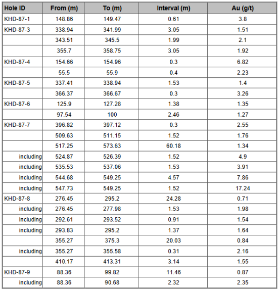
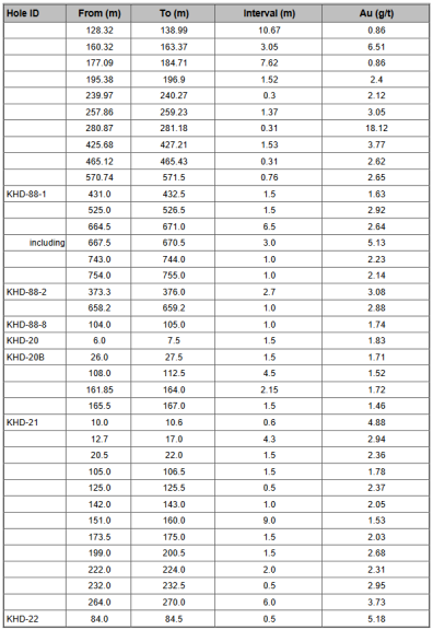
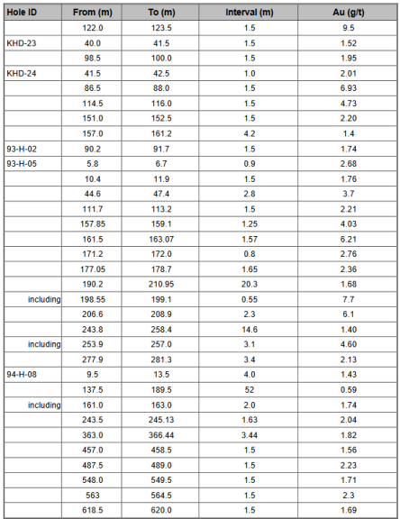
Four (4) DDHs from their 1993–1995 drilling campaign were on the Hurd Block. The holes drilled by Kerr Addison and Silver Century intersected extensive but generally low–grade gold mineralization. The best intervals with Au assays are presented in Table 6.1.
Table 6.1 – Summary of the historic work on the Hurd Block
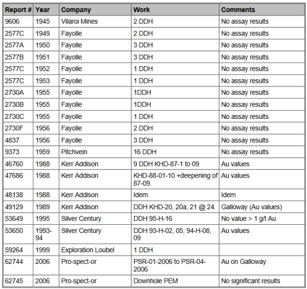

Table 6.2 – Best results from historical drilling on the Hurd Block between 1987 and 1995
In 1997, Loubel Explorations signed an option for the Hurd Block. As part of their drilling campaign in 1999, which focused on the Galloway, Soaker Hill and Ogima North occurrences, Loubel completed one hole (803 m length) that yielded only low Au and Cu grades from three (3) analyzed core samples analyzed before abandoning the property in 2005.
From 2005 to February 2007, Pro-Spect-Or Resources drilled two (2) DDHs and completed downhole geophysical surveys in 2006. The DDHs intersected sulphidic mineralization (typically pyrite and chalcopyrite) in strongly altered, silicified and epidotized volcanic rocks. In general, the mineralization encountered was spatially associated with faults or shear zones (Provost, 2006). The best drill intersections are presented in Table 6.3.
Table 6.3 – Best results from the Pro-Spect-Or drilling campaign on the Hurd Block (Soaker Hill showing ) in 2006

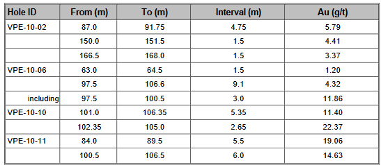
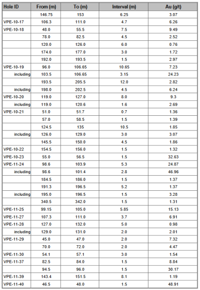
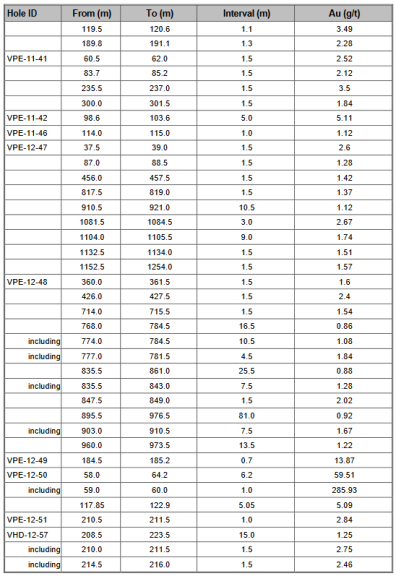
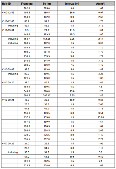
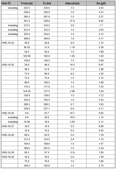
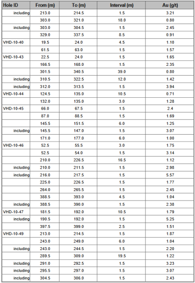
Between 2009 and 2012, Vantex drilled an additional 83 DDHs on the claim block most of which intersected mineralization characterized by quartz-carbonate veins with sulfide-bearing sericite-carbonate alteration. The best mineralized intervals are presented in Table 6.4.
Table 6.4 – Best results from Vantex’s drilling on GP, Moriss and Hurd showings 2009 and 2012

The Renault Bay Block consists of six (6) claims in the northwestern part of the Galloway Property, west of Lac Dasserat (Figure 5). It does not host any significant showings. Historically, exploration on the Renault Bay claims has targeted several parallel structures hosting quartz-carbonate-pyrite-(chalcopyrite-molybdenite) veining within the Renault Bay syenite intrusion and surrounding andesite units of the Blake River Group. Table 7 summarizes the historical work on the claim block.
Table 7 – Summary of the historical exploration work on the Renault Bay Block
Prospectors excavated numerous trenches and a shallow pit in the early 1920s and 1930s. In 1973, Boston Bay Mines conducted magnetic and VLF-EM geophysical surveys, identifying several target areas that warranted further exploration (Beard, In 1982, Aur Resources began their exploration work with a magnetic and VLF-EM survey, followed by four (4) DDHs in 1983. The DDHs intersected Au- and Au-Cu mineralization characterized by pyrite.

Drilling
In 1952 and 1954, Fayolle drilled one (1) DDH each year, but no assay results were reported.
In 1959, Bracemac Mines Inc. drilled two (2) shallow core boreholes, but no assays are presented in the report. (Table 7.1).
In 1982, Aur Resources began their exploration work with a magnetic and VLF-EM survey followed by four (4) DDHs in 1983 . The DDHs intersected Au-Cu mineralization characterized by pyrite-molybdenite-bearing silicified zones associated with quartz-carbonate veins and pyrrhotite-chalcopyrite bearing epidote-chlorite alteration zones, respectively. One (1) DDH in Vantex’s 2011 drill campaign (VBR-11-01) was on the claim block but no significant mineralization was intersected. The best drill hole intercepts from these campaigns are presented in Table 7.2.
Table 7.1 – Summary of the historical drilling on the Renault Bay Block

Table 7.2 – Best results from drilling on the Renault Bay Block between 1982 and 2011

The Lac Fortune claim block consists of 16 contiguous claims in the easternmost extension of the Galloway Property (Figure 5). Two (2) Au-Cu showings are present on the claim block: Lac Sanies Zone Est and Lac Sanies Zone Ouest. The first exploration work was carried out by Calumet Mining and Evangeline Gold & Copper Mines (work not filed). Old compilation maps show that Evangeline drilled at least six (6) short holes near the east shore of Lac Saniès. Between 1936 and 1938, Amcoeur Gold Mines performed mapping, trenching, and drilled 2 DDHs on the claim block (Ross, 1938; Arncoeur Mines, 1938). In 1951, Golden Shaft Mines completed magnetometer and resistivity surveys and a drilling program, but none of the holes from this program fell on the claim block.
In 1975 and 1978, stripping and sampling on the Bédard claims returned assay results up to 2.18 g/t Au. Grab samples from the 1978 sampling program returned multiple high assay values up to 42 g/t Au. In 1983, Dasserat Resources completed magnetic, IP and VLF-EM surveys and geological mapping, and produced a short technical report.
Table 8 – Summary of the historical exploration work on the Lac Fortune Block
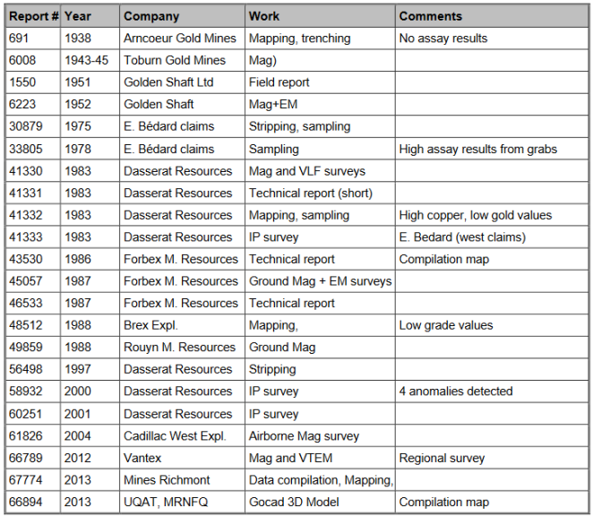
In 1986-87, Forbex completed property assessments, magnetic and IP surveys, and a series of 29 DDHs (260 series holes), two (2) of which were collared on the claim block (260-21 and 260-22).
In 1987-88, Brex Exploration carried out a structural assessment and a 38-hole diamond drilling program. In 1988, Ressources Minières Rouyn conducted a ground magnetic survey that covered the southwestern part of the claim block.
Following a few years of exploration inactivity, Dasserat Resources undertook an extensive drilling, mapping, and sampling program in 1997-1998 (Kelly, 1998; Jacob and
Kelly, 1999). In late 2000, Dasserat Resources commissioned an IP survey that resulted in the delineation of four (4) anomalies. In 2001, Dasserat completed a 14.9-line km IP survey.
In 2004, a small portion of the claim block was covered by an airborne magnetic survey conducted by Cadillac West Explorations Inc., yielding several magnetic anomalies coinciding with magnetic lithological units and the Larder Lake–Cadillac Fault Zone.
In 2012, Vantex’s regional magnetic and VTEM survey covered most of the Galloway Property, including the Lac Fortune block
Drilling
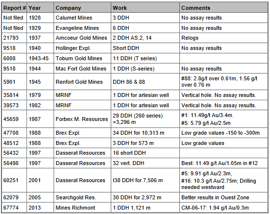
Old compilation maps show the six (6) short holes near the east shore of Lake Saniès drilled by Evangeline Gold & Copper (Table 8.1).
Between 1936 and 1938, Amcoeur Gold Mines performed mapping and trenching and drilled 2 DDHs on the claim block. In the 1940s, various exploration companies carried out four (4) diamond drilling programs for a total of 45 DDHs (4,600 m). Fourteen (14) of these DDH fell on the claim block.
In 1951, Golden Shaft Mines completed a drilling program, but none of the holes fell on the claim block .
Table 8.1 – Summary of the historical drilling on the Lac Fortune Block
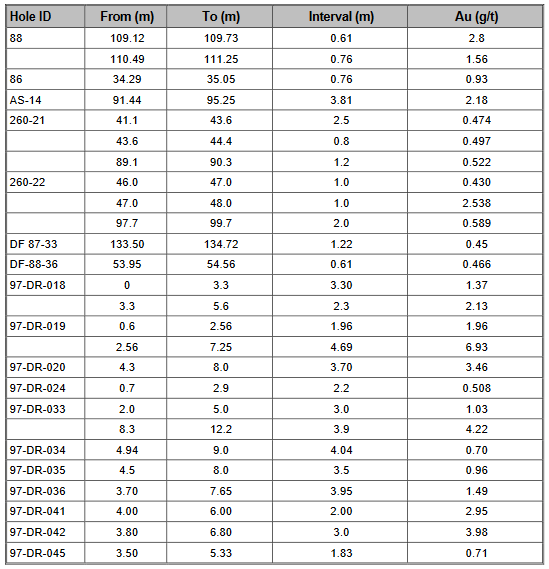
In 1986-87, Forbex completed a series of 29 DDHs (260 series holes), two of which were collared on the claim block (260-21 and 260-22). The best results are summarized in Table 8.2.
In 1987-88, Brex Exploration carried out a 38-hole diamond drilling campaign (DF-87 and DF-88 series), six (6) of which were drilled on the claim block. Only one low-grade interval was intersected (Table 8.2).
Following a few years of exploration inactivity, Dasserat Resources undertook an extensive drilling, mapping and sampling program in 1997-1998. Sixty-three (63) shallow DDHs were collared on the claim block (97-DR- and 98-DR- series holes). They intersected some narrow but promising Au-mineralized intervals (Table 8.2).
In 2001, Dasserat completed another 38-hole drill campaign with 28 DDHs collared on the claim block and intersected several Au-mineralized intervals (Table 8.2).
Table 8.2 – Best results from drilling on the Lac Fortune Block between 1936 and 2011
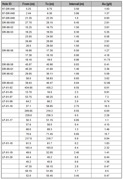
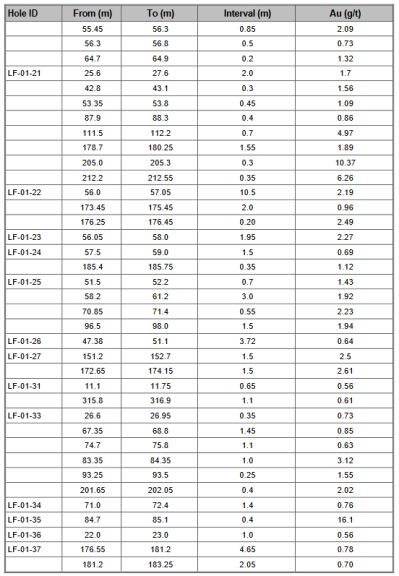
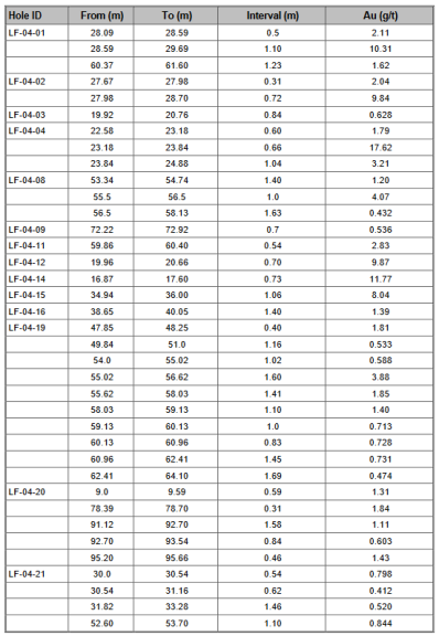
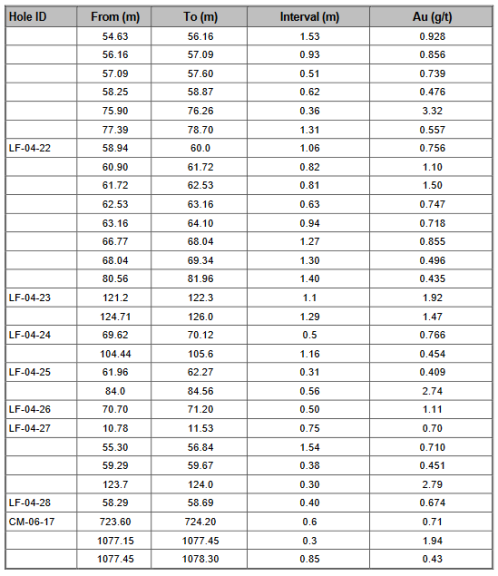
In 2004-2005, SearchGold Resources carried out a 30-hole diamond-drilling program Twenty-seven (27) of the holes were collared on the Lac Fortune Block. Most of these holes intersected several mineralized intervals (Table 8.2) .
Richmont Mines Inc. drilled a single drill hole on the claim block as part of their 2006 drilling program, intersecting a couple of narrow, Au-mineralized intervals (Table 8.2).
Vantex Resources aquired the Galloway gold project in 2007.
In 2009, Vantex carried out a 4,320-metre diamond drilling program (VHD-09-01 to 23) mostly on the Galloway-Pitchvein showing. The main objective of this program was to verify if historical results could be duplicated and to extend the known mineralization. In addition to the drilling, the company carried out limited trenching, cleaning of old trenches and channel sampling near the Pitchvein showing area (Blood Trench and Castor area). Re-logging and re-sampling of old core was also performed (2006). The program was done under the supervision of geologist Jeannot Théberge.
Vantex followed the gold-bearing system (informally defined at a minimum grade of 100 ppb Au) over an area of 250 X 250 m and from surface down to a vertical depth of 250 metres. The mineralization is bounded to the south by south dipping sediments of the Cobalt Group although the mineralization appears to extend beneath the Proterozoic cover.
In 2010, Vantex resume drilling on the Galloway-Pitchvein (GP) Zone and completed it with 29 holes and five hole deepening for a total of 8,585 metres (VHD-10-24 to 55, deepening of VHD-09-01, 02, 20, 21 and 22). Moreover, a total of 117 channel samples were taken on the GP and Hurd showings. Assay results of the channel sampling (0.56 g/t Au) are globally similar to the ones observed from core intersections drilled on the GP Zone (GM 66397). The entire GP Zone diamond drill hole database, along with a mineralogical study and metallurgical tests, were sent to SRK Consulting of Toronto to prepare a 43-101 resource estimate. Drilling work was also carried out on the Ogima Block (738 m.), the Soaker Hill showing (449 m.) the rediscovered Hendrick occurrence (1,005 m.) and the new Moriss Zone (3,428 m.).
In 2011, 23 diamond drill holes totaling 5,691 metres were mostly drilled on the Moriss Zone (VPE-11- 24 to 46). The mineralized zone is supposedly associated with a mafic intrusion, highly altered in carbonate-sericite, and oriented WNW/-45° N. Two other satellite zones were identified north (N1, N2) of the main zone and one south (M1). During that same year, 23 overburden drill holes for 287 metres were also completed over the Moriss Zone (GM 66317). In the Hendrick Zone, hole VPE-11-36 confirmed the presence of that a wide auriferous zone at the -300 m level. Finally, hole VBR-11-01 (273 m.) was drilled on an interpreted NNE trending structure but apparently failed to find it (GM 66151).
In 2012, 6,105 metres were drilled in 15 holes in four areas; the Hendrick Zone (2,537 m), the Moriss Zone (685 m), the Hurd Showing (2,004 m) and Perron West (885 m). Assay results from the two holes drilled on the Hendrick Zone confirmed the extent of the low-grade gold mineralization in this area (0.50 g/t Au over 199 metres in VPE-12-47 and 0.79 g/t Au over 148.5 metres in hole 48). The best assay results of the three holes drilled on the Moriss Zone were 13.87 g/t Au over 0.70 metre in hole VPE-12- 49 and 59.51 g/t Au over 6.20 metres in hole VPE-12-50. Drillings on the west side of the Perron Block returned no significant values with the exception of hole VPE-12-53 which intersected 0.69 g/t Au over 3.0 metres in a carbonate-sericite schist. In the Hurd area, hole VHD-12-56 was targeting a VTEM anomaly when it intersected 0.82 g/t Au over 10.5 metres in a carbonate-sericite schist. Boreholes VHD-12-57 and 59 were respectively drilled 100 m north and 125 m north-east of hole VHD-09-19 which intersected 0.64 g/t Au over 45.0 metres. VHD-12-57 intersected 0.53 g/t Au over 124.5 metres and VHD-12-59 returned a 102 metres wide core section grading 0.62 g/t Au. Finally, hole VHD-12-60 was targeting a combined I.P. and low Mag anomalies when it intersected 1.73 g/t Au over 4.8 metres of core length in quartz-carbonate veins associated with 5 to 65% pyrite.
In May 2011, Vantex commissioned SRK Consulting (Canada) Inc. (SRK) to visit the Galloway project and prepare a geological and mineral resource model for the GP gold deposit. The services were rendered between July 2011 and August 2012, leading to the preparation of the Mineral Resource Statement, which represents the initial mineral resource evaluation prepared for this project.
Also In 2011, Vantex contracted URSTM of Rouyn-Noranda, Quebec to conduct preliminary mineralogical studies and leaching tests on samples from the Galloway property.
The testing material was a composite core sample (4.70 kg) taken from the remaining half core of four boreholes drilled by Vantex (VHD-09-07, VHD-09-12, VHD-09-13, and VHD-09-2). The sample is representative of the Galloway-Pitchvein gold mineralization. From the composite sample, three lots of 12 samples, each 0.5 kilogram in weight, were produced for testing. The three lots were named GL-1, GL-2, and GL-3.
The main objective of this work was to determine the grain size, reaction agents and time required for optimal gold recovery using the cyanidation method. Several tests using different grain sizes, concentration methods (gravimetric and Knelson) and cyanidation time were performed during this study. The average grade of all the gold mineralization material used for the test work was 0.50 g/t gold, which is representative of the gold mineralization for the GP gold deposit.
The main findings of the report are:
In 2012 Vantex published a mineral resource on the Galloway Gold Project
Vantex Resources used 17 historical drill holes for a total of 4,896 metres drilled by previous operators, the 52 holes they drilled for a total of 12,820 metres from 2009 to 2011 and the channel sampling program in 2011 to validate historical sampling results and delineate the extent of the gold mineralization at the GP target in order to support their mineral resource evaluation. During their evaluation process two other exploration targets in Hendrick and Moriss were also investigated.
At the time The Galloway project consisted of seven distinct non-contiguous blocks (101 individual claims and three mining concessions) that covered a total area of 2,574 hectares in the western portion of what is now owned and operated by Fokus Mining.
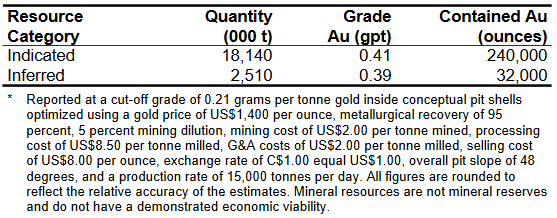
Released on August 1st, 2012, The Mineral Resource Statement presented was prepared by Sébastien B. Bernier P.Geo., (APGO#1847, OGQ #1034), an independent Qualified Persons pursuant to National Instrument 43-101. The initial resource estimated on Gallaway carried an indicated resource of 240,000 ounces of gold contained in 18,140,000 tons grading 0.41 g/t Au and an inferred resource of 32,000 ounces of gold contained in 2,510,000 tons grading 0.39 g/t Au.
The Full report can be found at
https://s3-us-west-2.amazonaws.com/logic-shops/bd68d89a-8930-4d66-8d52-38b2bf28ddab.pdf
In 2013, a 2,908 metres diamond drill program in 16 holes was completed in the Moriss Zone. The zone was intersected at vertical depths between 190 and 220 metres. Visible gold was observed in borehole VM-13-08 where an intersection graded at 137.9 g/t Au over a core length of 1.40 m. The presence of two gold structures parallel to the Moriss zone namely, the N1 and M2 zones was also observed.
In 2020 Fokus acquired the Galloway Gold Project along with all the previously discussed claims and a drill program was immediately initiated along with a wide range of geophysics on the western portion of the property with a focus on connecting Morris, Hendricks and GP.
As a complement to Fokus’ 2020 exploration program (discussed below), Novatem Inc. flew a high- resolution geophysical airborne survey over the western third of the Property in December 2020. A network of 151 flight lines oriented N000º, spaced every 25 m, with the MAG sensor kept at a mean elevation of 27 m above ground, allowed for the company to acquire 628.1 line-km of magnetic data. The survey unveiled three buried syenite bodies.

In February 2021, Fokus retained the services of an external firm (Earthlabs, formerly Goldspot Discoveries) for a more in-depth analysis of the high-resolution magnetic data acquired in the western portion of the Property during Novatem 2020 survey. The mandate included: 1) reprocessing the data using enhancement filters to generate products that will aid with the structural and geological mapping on a property-wide scale; 2) 3D magnetization vector inversion to allow for 3D visualization of the magnetic targets and lithological units based on their magnetic susceptibility contrasts; 3) a textural enhancement analysis to highlight the linear discontinuities and favourable exploration targets; 4) producing a set of interpretative maps by emphasizing the key elements obtained from the consulting work; and 5) a technical and interpretation report. The 3D inversion model showed a magnetic mass at the Hendrick showing. It is interpreted by the presence of the porphyritic intermediate intrusion, which often carries magnetite. Two other large magnetic masses were also interpreted in the 3D inversion model. Previous geological and drill hole information supports the conclusion that the area underlying these magnetic masses is covered by intermediate intrusions carrying gold and copper mineralization (See Fokus press release, April 21, 2021).
In May 2021, a very-high resolution heliborne magnetic survey was flown over the remainder of the Property not covered in December 2020. The aim was to discover areas of high magnetic susceptibility that may correspond to buried syenite intrusions similar to the one in the Hendrick Zone. A total of 1,087 line-km of magnetic data was flown, oriented N000º, spaced every 25 m. The survey was carried out following the lowest possible flight surface above the vegetation and lakes. Because lakes were present throughout the surveyed area, the flight clearance was very variable. The magnetic survey unveiled four circular magnetic anomalies potentially representing buried syenite bodies. An exploration hole was drilled into one of them (GA-21-40),
intersecting an intermediate intrusive locally mineralized in pyrite and chalcopyrite, which bears some similarities with the syenite in the Hendrick Zone (see Fokus press release of September 16, 2021).
Diamiond Drilling
In 2020 and 2021, 59 diamond drill holes were completed for a total of 32,345.6 m (Figure10-). A total of 15,483 samples were sent to a laboratory for analysis for a total of 22,836.45 m of core analyzed. In addition, the focus of work was located on the western portion of their overall land package which includes all the original 8 claims discussed above. The goal was to connect the Morris, Hendricks and GP based on drilling and geophysics highlighting the potential for deep intrusive.
Table 9 : Best results from the 2020-2021 drilling campaigns on the Galloway Project.
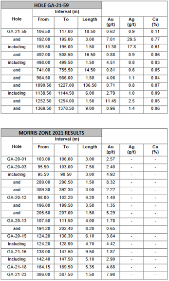
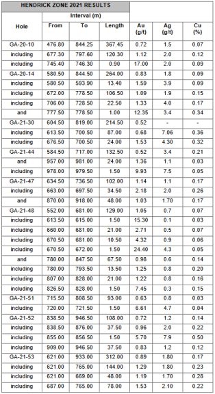
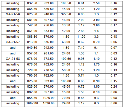
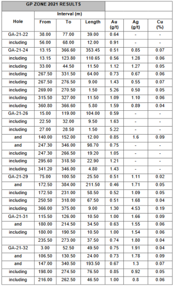
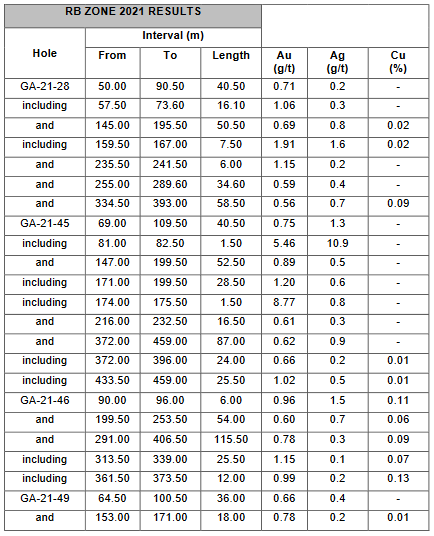
Assays continued being received into 2022, beginning with a January 20th announcement of a series of holes drilled near the Hendicks zone. Holes GA-21-28, 45, 46 and 49 made it possible to identify a new zone located east of the GP zone. This new zone called RB and is in a geological context similar to the Hendrick zone which opens up the potential for Au-Cu Porphyry mineralization in the main Renault Bay intrusion.
The two best holes reported were drillhole no GA-21-53 located in the Eastern portion of the Hendrick zone intersected the gold bearing zone over 312 meters grading 1.18 G/T AuEq including 144 meters at a grade of 1.67 G/T AuEq, 48 meters at a grade of 1.65 G/T AuEq and 78 meters grading 1.90 G/T AuEq and Hole GA-21-47 located in the same area intersected the zone over 102 meters grading 1.42 G/T AuEq including 35.5 meters at a grade of 2.61 G/T AuEq and 48 meters grading 1.32 G/T AuEq.
Main highlights:
Table 10 – Hendricks Zone Drill Results
| Holes* | From | To | Length** | AuEq | Zones |
| (m) | (m) | (m) | g/t | ||
| GA-21-46 | 291 | 406,5 | 115,5 | 0,93 | RB (new zone) |
| Including | 313,5 | 339 | 25,5 | 1,26 | |
| Including | 361,5 | 373,5 | 12 | 1,19 | |
| GA-21-47 | 634,5 | 736,5 | 102 | 1,42 | Hendrick |
| Including | 663 | 697,5 | 34,5 | 2,61 | |
| and | 870 | 918 | 48 | 1,32 | |
| GA-21-48 | 552 | 681 | 129 | 1,16 | Hendrick |
| Including | 658,5 | 681 | 22,5 | 2,82 | |
| Including | 670,5 | 681 | 10,5 | 4,42 | |
| and | 780 | 847,5 | 67,5 | 1,21 | |
| Including | 780 | 793,5 | 13,5 | 1,57 | |
| Including | 801 | 828 | 27 | 1,48 | |
| GA-21-52 | 838,5 | 946,5 | 108 | 0,95 | Hendrick |
| Including | 838,5 | 876 | 37,5 | 1,31 | |
| Including | 909 | 946,5 | 37,5 | 1,03 | |
| GA-21-53 | 621 | 933 | 312 | 1,18 | Hendrick |
| Including | 621 | 765 | 144 | 1,67 | |
| Including | 621 | 669 | 48 | 1,65 | |
| Including | 687 | 765 | 78 | 1,90 | |
| and | 832,5 | 933 | 100,5 | 0,88 | |
| Including | 865.5 | 880,5 | 15 | 1,84 |
Discovery of the RB zone in holes GA-21-28, 45, 46 and 49.
Additional results from drilling the Hendricks zone were announced on February 23rd, whereby the company intercected 322 m grading 1.08 g/t AuEq in Hole GA-21-56, including intervals of 2.31 g/t AuEq over 16.5 m, 3.19 g/t AuEq over 12 m and 1.46 AuEq over 13.50 m.
Hole GA-21-58, located at the extreme east of this same showing, revealed a first gold zone of 100.50 metres along the hole, at a grade of 1.18 g/t AuEq including 1.34 g/t AuEq over 58.50 m. This same hole revealed a second gold zone of 108 metres at a grade of 0.89 g/t AuEq including 15 metres at a grade of 1.59 g/t AuEq as well as a third gold section of 70.50 metres at a grade of 0.79 g/t AuEq including 24 metres at 1.26 g/t AuEq.
In April 2022 Fokus announced the discovery of a new gold zone located at about 700 metres east of the GP-RB showings and about 400 metres south of the Hurd showing. Hole GA-21-59, which was over 1,500 metres long, intersected several gold intersections from 190 to 1,260 metres. This drilling was done to test a magnetic signature similar to the Hendrick zone and the results seem to demonstrate that the environment is favourable for auriferous horizons near the surface containing several significant gold grades. Thus, a grade of 7.01 g/t Au over 3 metres was intersected between 192 and 195 metres while a grade of 4.51 g/t Au over 1.5 m was detected at 480 vertical metres.
Additionally, a grade of 11.45 g/t Au over 1.5 m was also intersected at a depth of 1,252.5 m. This high grade is included in a zone of 136.5 m at a grade of 0.83 AuEq including 1.43 AuEq over 7.5 m and 2.94 AuEq over 6 m (see table below).
Table 11 – Hole GA-21-59
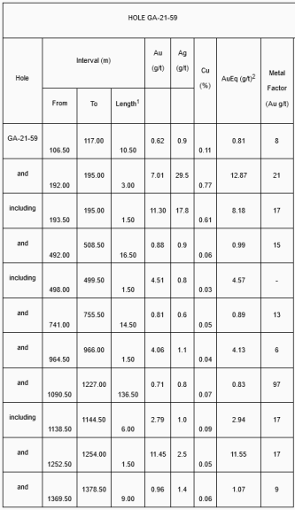
This new discovery is in addition to the discovery of the RB zone in 2021, which is in the eastern extension of the GP zone and it highlights the potential for a low-grade, high-tonnage gold deposit in a porphyry-copper type system (Hendrick – GP – RB) and the potential for richer gold zones such as the Moriss located west of the GP zone.
The Company recognizes the importance of finding other higher grade gold zones in an environment close to the low-grade zones to optimize the overall grade. Which is why, during the 2023 drilling program, the company will test other gold zones previously identified to contain higher grades. Following their detailed compilation of historical data, the Company has thus identified several showings with such potential, ie. The Renault Bay (12.44 g/t Au over 1.63 m), Hurd (2.68 g/t Au over 9 m), Pond Zone (7 g/t Au over 3 m), Moriss (11.48 g/t Au over 5.35 m) and Soaker Hill (8.57 g/t Au over 4.87 m and hopes to confirm the gold potential of these new targets, by drilling in 2023.
In November, 2022 the company completed its metallurgical testing which was needed to complete a 43-101 Technical Report Resource Estimate.
2023 Technical report
In May 2023, Fokus filed a 43-101 Technical report on the Galloway Gold Project with an updated mineral resource. Using a gold price of $1,750 per ounce and a cut off of .90 g/t the resource estimate at Galloway now sits at 1,419,600 oz/Au, with an average grade of 1.07 g/t Au within 41,195,000 tons of rock. At the time of this report the resource is still in the inferred category and will require infill drilling to convert the resource into the indicated category. This resource encompasses the Hendricks, GP and RB zones on the western portion of the property.
Table 12 – Resource Estimate 2023

Table 13 – Inferred resources based on varying gold price and cut off grades

The only factor that prevents the mineralized material from being classified to a higher category (from Inferred to Indicated or Measured) is the inability to confidently correlate mineralized zones from one drill hole to another with the present drill spacing. Additional drilling at depth and toward the east will help reclassify some Inferred material as Indicated. Furthermore, it was concluded in the report that the RB and Hurd deposits are probably related to the GP deposit. However, they will require additional drilling to confidently connect the zones.
The technical report contains more details on geological modelling, minerology, lithologies and the mettalurgical work done on the property. The full technical report can be found at https://ceo.ca/content/sedar/FKM-20230508-Technical-report-NI-43-101-English-8c90.pdf
The Galloway Gold Project represents a promising opportunity in the renowned Abitibi Greenstone Belt of Quebec, Canada. The project has demonstrated that there is significant gold mineralization through successful exploration activities by various operators over the years, and Fokus is focused on further developing the project. After extensive data compilation work and 40,000m of drilling, the company now has a better grasps of the controls enabling amore efficient use of the drilling funds . However, this is just the start of a major undertaking for Fokus on the Galloway project, as the company will prioritize infill drilling and testing of the strike extensions of the known mineralised zones and will continue to drill the newly discovered RB mineralised zone in the short term in an attempt to expand and better qualify the gold resource on the western part of the project.
For more information, please visit https://fokusmining.com/
Disclosure
At the time of creation, Fokus Mining is a client of Insidexploration Analytics Inc.
Disclaimer
Project Reports are under the Issuers editorial control and published on Insidexploration. Information contained in Project Reports may change over time and may differ from other sources. For more information, please reference https://fokusmining.com/ for Corporate, Technical Information and Project Specifications for the latest public disclosures.
Further;
The information herein is meant for informational and entertainment purposes only and does not constitute a recommendation to buy or sell securities. While every effort is taken to ensure the accuracy of everything contained on this website, no warranty of same is expressed or implied. While we endeavour to keep the information up to date and correct, we make no representations or warranties of any kind, express or implied, about the completeness, accuracy, reliability, suitability, or availability with respect to the website or the information, products, services, or related graphics contained on the website for any purpose. While every caution has been taken to provide readers with most accurate information, we recommend that you consult a registered investment professional in your jurisdiction before undertaking any investment in any asset whatsoever.
The content published on Insidexploration.com is based on current events, historical data, company news releases, sedar filings, technical reports and information provided by the companies we work with. These publications may contain forward-looking statements, including but not limited to comments regarding predictions and projections. Forward-looking statements address future events and conditions and therefore involve inherent risks and uncertainties. Actual results may differ materially from those currently anticipated in such statements. The publications on Insidexploration.com are for informational and entertainment purposes only and are not a recommendation to buy or sell any security. Always do your own due diligence and talk to a licensed investment adviser prior to making any investment decisions. Please be sure to read company profiles on www.SEDAR.com for important risk disclosures.
Multimedia and analytical due diligence database for the investing community.
About Us
Contact Us
Disclaimer
Privacy Policy
Terms of Service
© Copyright 2022 insidexploration.com
Contact us: insidexploration@gmail.com
© Copyright 2022 insidexploration.com | Multimedia and analytical due diligence database for the investing community | Contact us: insidexploration@gmail.com