


Extended Research


Extended Research
- Trending
- Comments
- Latest

St-Georges Eco-Mining Corp. (CSE: SX) (OTCQB: SXOOF) (FSE: 85G1) is a junior exploration company with a portfolio of Critical and Strategic Minerals Projects, including the Manicouagan Project, the Julie Project, and the Notre-Dame Niobium Project, all located in Quebec, Canada. Through its subsidiary, Iceland Resources, the Company owns all the active exploration licenses in the country, including the Thor Gold Project. Using an eco-mining approach, the Company develops metallurgical technologies through its subsidiary, St-Georges Metallurgy, including a new system for processing lithium, which it then applied to battery recycling through its subsidiary, EVSX. The Company expanded into indigo hydrogen with its H2SX subsidiary to support its metallurgical process that allows battery recycling and lithium hydroxide production. Together, the synergies between St-Georges and its subsidiaries create a circular green economy focusing on the critical and strategic minerals supply chain.

Project Overview – A brief description of the Manicouagan Critical and Strategic Minerals Project
Project History – A detailed account of all historical work done on the property going back to the first discoveries on the property
St-Georges Eco-Mining Corp. Exploration – A detailed chronological account of the Company’s exploration efforts and results since acquiring the project
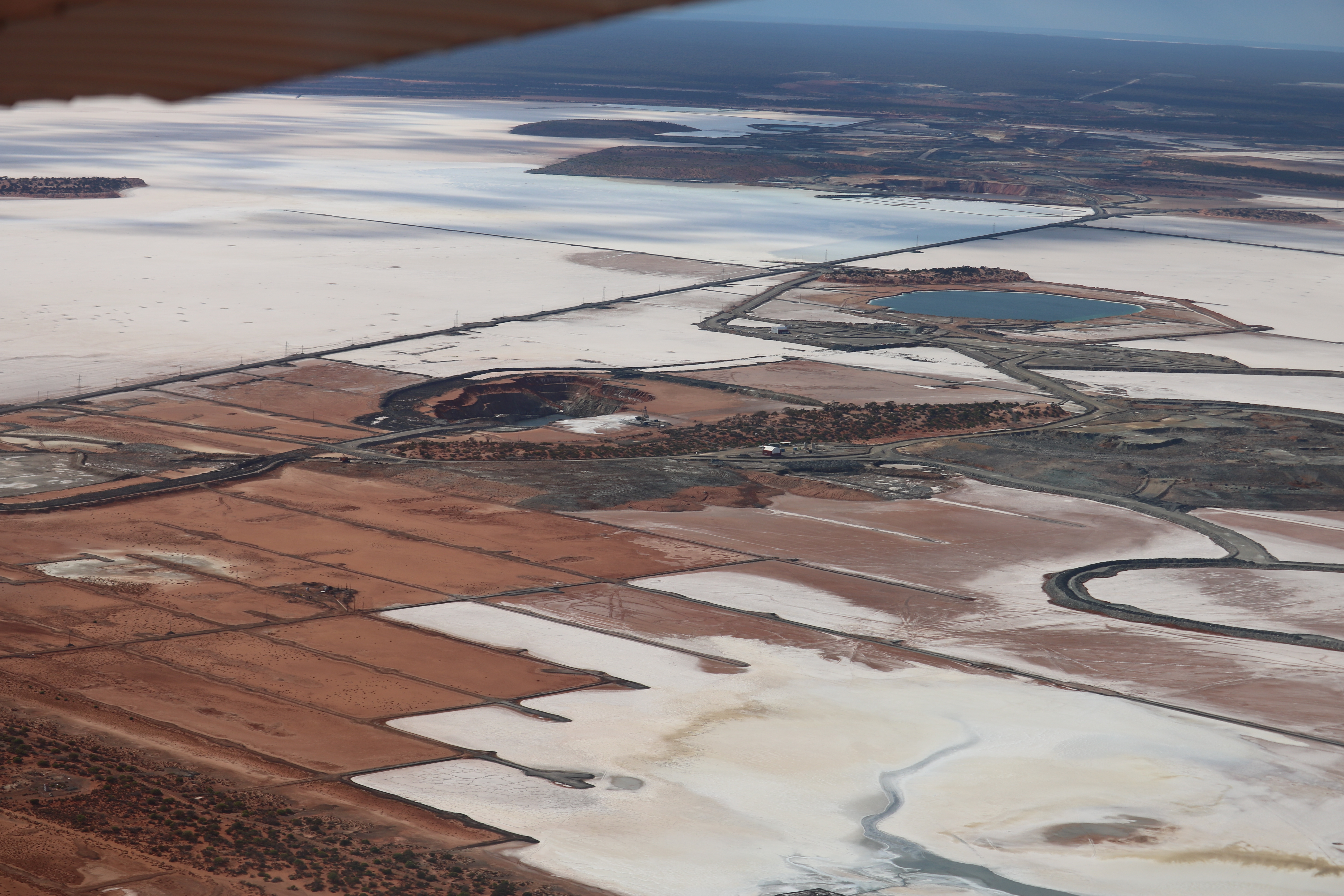
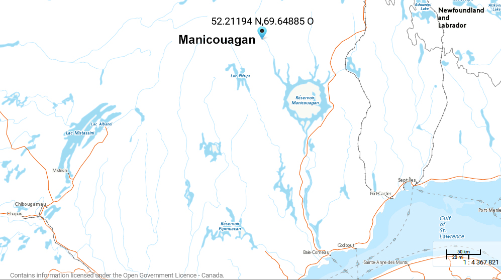
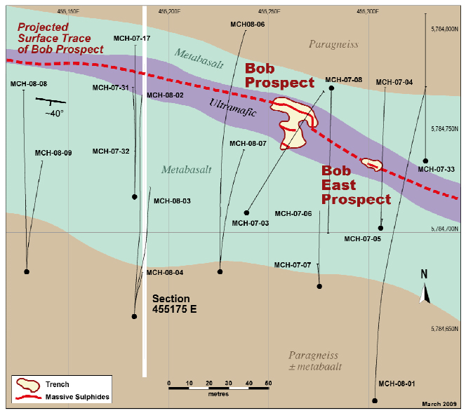
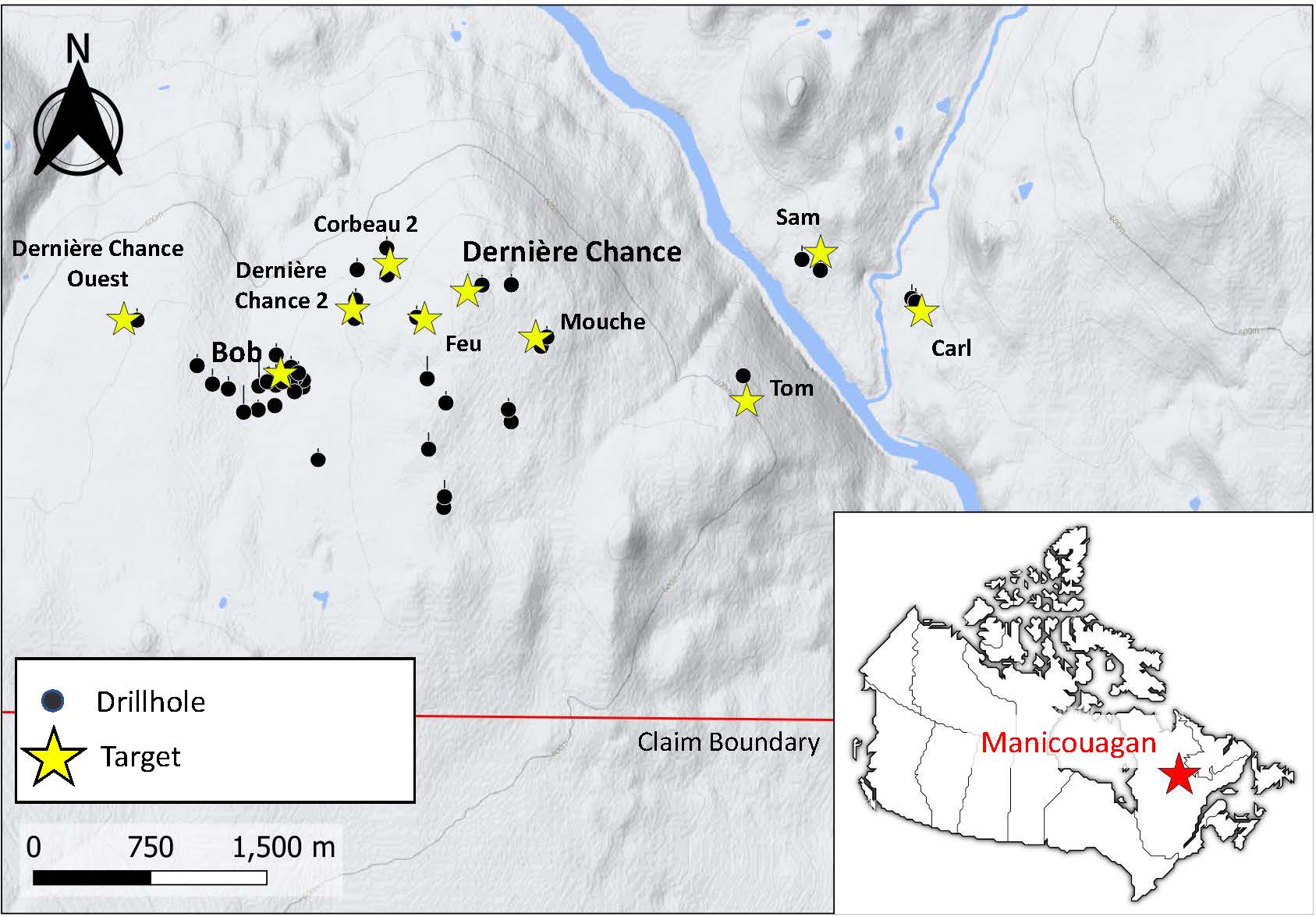
The Manicouagan Critical and Strategic Minerals Project consists of 388 claims covering an area of 20,474 hectares (204.7km2) and is located approximately 70 km north of the Manicouagan Crater 350 km northwest of the city of Baie-Comeau, in the province of Quebec. The property can be accessed via Camp Hélène by air from either Baie-Comeau or Gagnonville’s paved airstrip. Gagnonville is situated just 100 km ESE on provincial road 389 which runs between Labrador, Newfoundland and Baie-Comeau, Quebec. (See Figure 1)
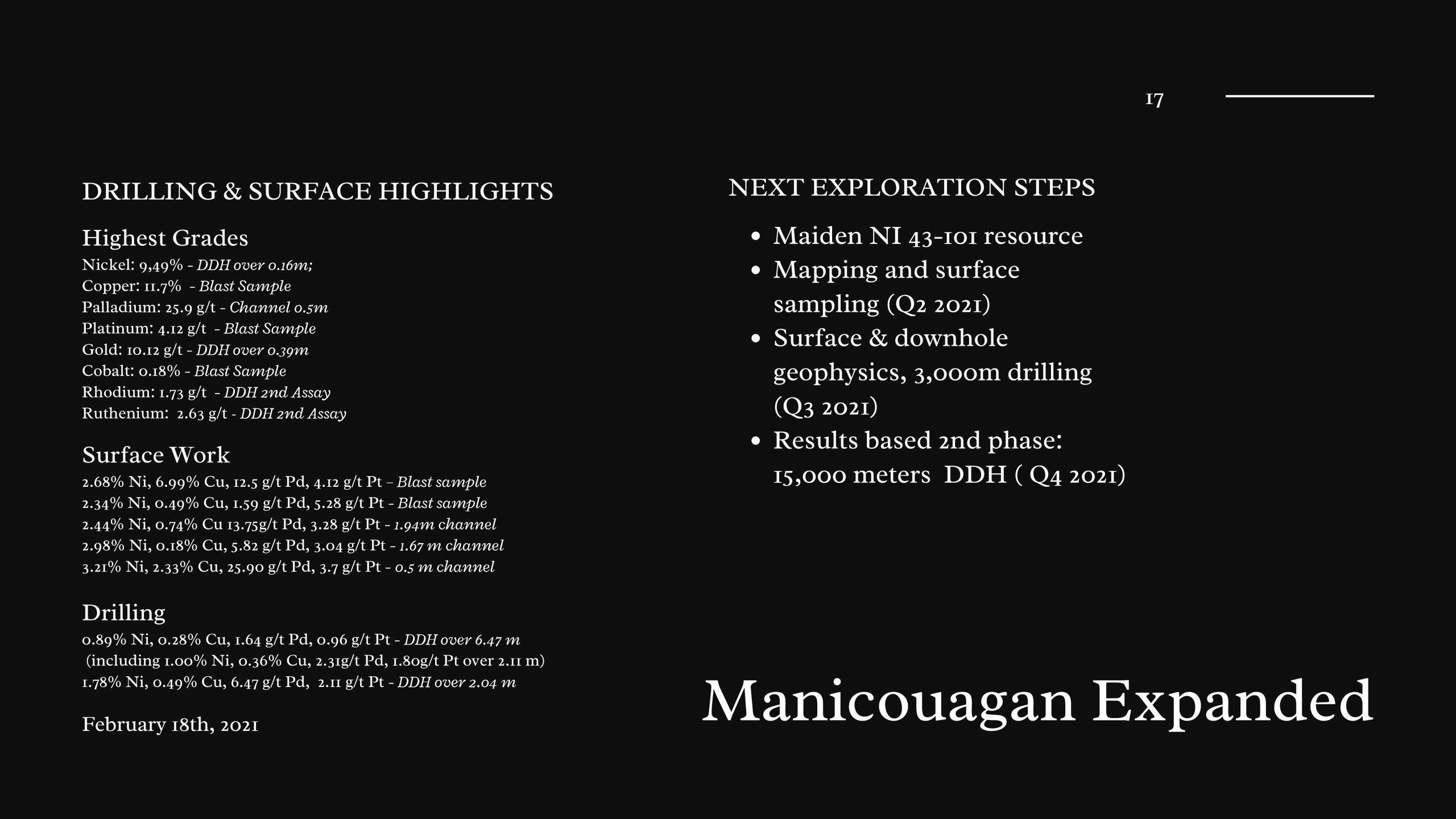
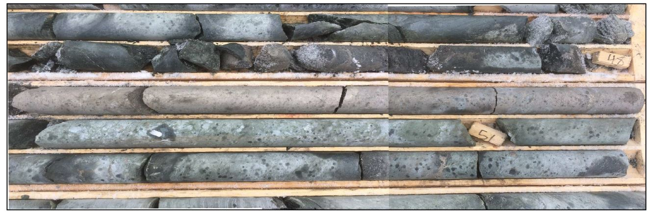
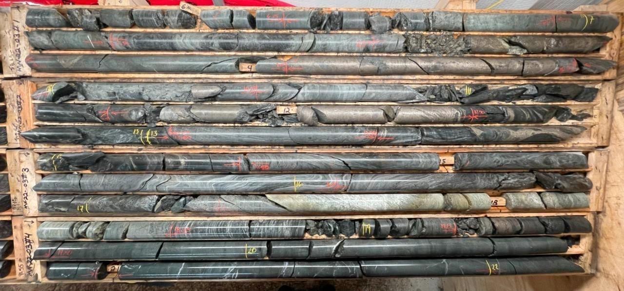
In recent years the project has yeilded success in defining a high grade corridor where they have reported grades of up to 5.11 g/t of platinum, up to 18.29 g/t of palladium, up to 1.73 g/t rhodium, up to 2.63 g/t ruthenium, up to 2.2% copper, up to 0.45% cobalt, and up to 9.49% nickel. Polished section and detailed hand sample examination studies reveal that sulphides include disseminated and massive varieties and include fine-grained recrystallized and coarse grained varieties. This aspect of the mineralization allows for the extraction of the various metals using a unique and green approach to extracting minerals.
Disclaimer: Historical information is provided solely for the reader’s convenience and has been sourced from publicly available sources. St-Georges Eco-Mining Corp is not responsible for the content’s accuracy, currency, or reliability, nor does the Company offer any guarantees in this regard.
The principal exploration targets on the property are for nickel, copper, and platinum group elements (platinum, palladium, rhodium and ruthenium) associated with reworked Archean ultramafic lithologies belonging to the Gagnon Terrane, which is part of the Grenville Geological Province. The majority of work carried out on the property before St-Georges acquired the property was done by Manicouagan Minerals Inc. with a focus on the Main Mouchalagane Claim Group or property. Additionally a ground geophysical survey was or carried out by Geosig in 2008 on the Western Mouchalagane Claim Group. At the time there was no systematic geological mapping or structural analysis reported for the area but field evidence, such as the presence of cross-folds in a few localities, suggest at least two periods of deformation.
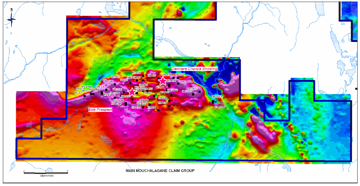
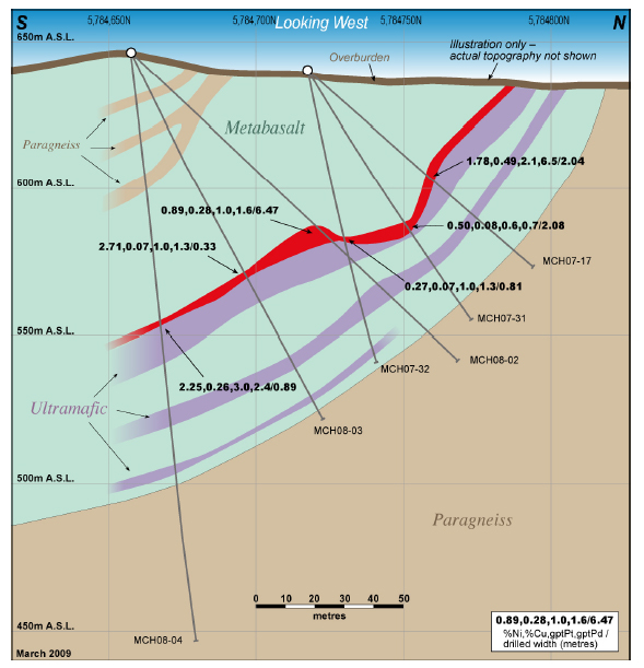
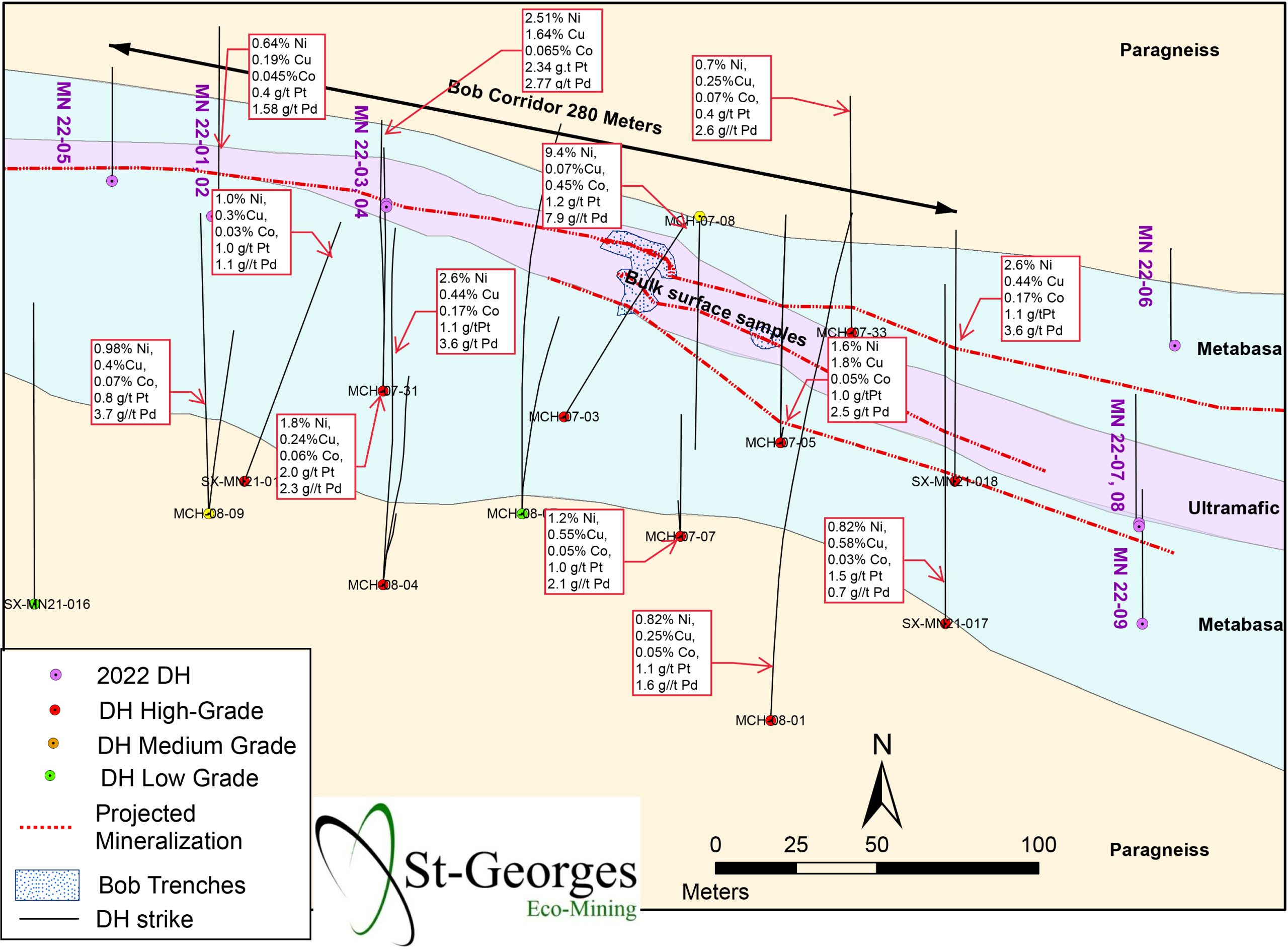
The Bob Showing up to this point had been traced by drilling for a total strike length of approximately 200 meters over widths of up to 6.5 meters. It appears to be directly associated with two, east striking, weak, third priority, short strike length electromagnetic (HLEM) conductors. Of potential significance is the presence of a strong, first priority, east striking, 400 meters long EM conductor which is situated just 200 meters south of the Bob Showing which remains untested. The Bob-East Showing, 45m away from the Bob Showing, returned outstanding assay results and among the eighteen (18) holes drilled proximal to Bob and Bob-East Prospect, sixteen (16) holes intersected Ni-Cu-PGE mineralization for approximately 200 meters along strike and to a depth of about 90 meters.
Polished section and detailed hand sample examination studies reveal that sulphides include disseminated and massive varieties and include fine grained recrystallized and coarse grained varieties. Fine-grained sulphides are recrystallized as are enclosing host rocks.
Grab samples
Channel samples
In addition to significant Pd and Pt concentrations, these grab & channel samples returned significant concentrations of up to 1,010 ppb rhodium (Rh) and 1,150 ppb ruthenium (Ru). However, most samples were not assayed for the entire suite of PGEs.
Bob and Bob East
Selected drill core samples from the Bob Ni-Cu-PGE Prospect that were analyzed for the complete suite of Platinum Group Elements (PGE) returned significant concentrations of rhodium (Rh) and ruthenium (Ru)
Highlights include;
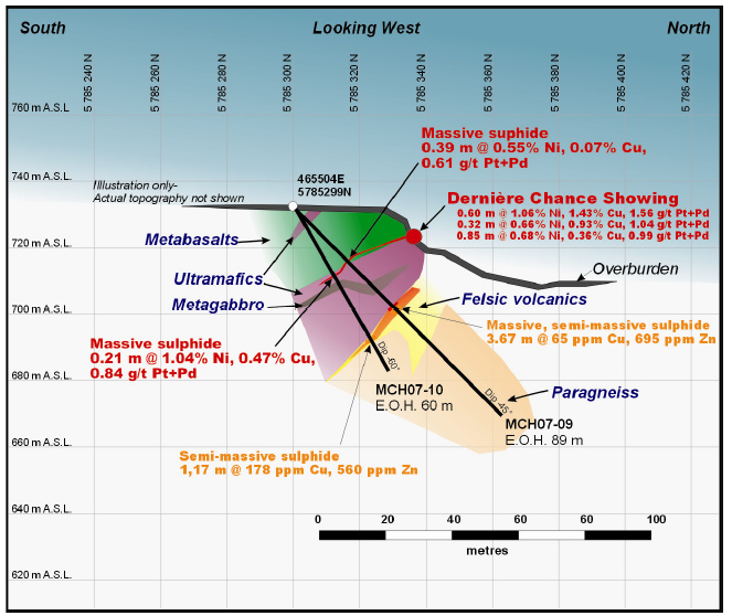
Ni-Cu-PGE mineralization at Dernière Chance is associated with an ultramafic unit at the interface with an overlying metabasalt. The host ultramafic unit was 19.67 meters in thickness in hole MCH-07-09 and was 22.29 meters thick in hole MCH-07-10.
Grab Sample
Channel sample
Drilling at the Feu was successful in extending the known surface Ni-Cu-PGE mineralization to a depth of approximately 40 m.
The Mouchalagane Property may offer some potential to host lode gold mineralization. At the Corbeau-2 Showing grab samples of 2.74 g/t Au were obtained from a minor quartz-hornblende vein. Also minor gold-arsenic mineralization associated with calcite alteration in the southern part of the property was intersected in MCH-07-16 (1.3 g/t Au over 0.95 meter).
Best surface gold results (sample 150501 : 2.81 g/t Au) came from Corbeau-2 showing area (Mouchalagane main grid). It confirms the previous grab sample that contained 2.74 g/t Au. Additionally, two (2) sulphide bearing felsic volcanics outcrops returned 1.2 and 1.1 g/t Au (samples 265904 and 150503). These occurrences are about 1 km apart, sample 265904 being located close to HLEM conductor D and sample 150503 being located right on HLEM conductor G.
Minor silver-copper (±platinum-palladium-gold-zinc) mineralization encountered in hole MCH-07-25 (0.68- 0.71% Cu – 2.3 g/t Ag over 0.29 m) and at the Mouche Showing in MCH-07-34 (0.2% Cu – 1.12 g/t Ag over 1.87 m, including 0.35% Cu – 1.8 g/t Ag over 0.60 m) is the lateral continuity of the “MRNF Mouchalagane Zone” where nine (9) samples assayed up to 2.0 g/t Ag, 3.6% As, 0.34% Zn. This mineralization is late staged associated with quartzcalcite alteration.
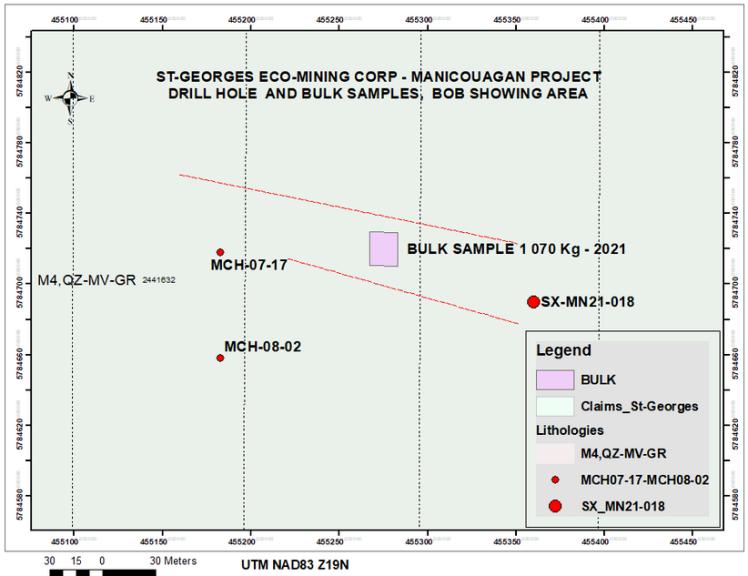
The highlight of the drill campaign was Hole SX-MN21-18 which hit 2 meters of massive sulphides within a 6 meter interval of massive to semi -massive mineralization. (See Figure 8) This hole was located 179 meters to the east and alongside the same conductors as historic Hole MCH-07-17 which assayed 1.78% Ni, 0.49% Cu, 914 ppm Co, 8.57 g/t Pd+Pt (2.11 g/t Pt + 6.47 g/t Pd), over 2.04 meters, including 3.82% Ni, 1.47% Cu, 0.21% Co, 23.40 g/t Pd+Pt (5.11 g/t Pt + 18.29 g/t Pd) over 0.57 meters.
The Holes MCH-07-17 and SX-MN21-18 seem to indicate that the Bob Showing extensions, East and West, are both opened along trend and remain open to depth.The drill Holes MCH-07-03 and 07-04 between MCH-07-17 and SX-MN21-18 didn’t reach or encounter the mineralized unit. (See Figure 9)
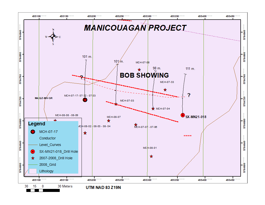
Table 1 – Representative PGE samples from bulk sample collected from the Bob Showing.
| Sample # | Weight | Pt | Pd | Os | Ru | Ir | Rh |
| kg | ppm | ppm | ppm | ppm | ppm | Ppm | |
| D591736 | 5.82 | 3.60 | 5.00 | 0.14 | 0.82 | 0.27 | 1.10 |
| D591737 | 3.16 | 4.50 | 1.40 | 0.09 | 0.80 | 0.23 | 0.52 |
| D591738 | 1.51 | 4.30 | 9.50 | 0.13 | 0.86 | 0.24 | 0.85 |
| D591739 | 3.16 | 2.50 | 5.60 | 0.15 | 1.00 | 0.31 | 0.89 |
| Average | 3.41 | 3.73 | 5.38 | 0.13 | 0.87 | 0.26 | 0.84 |
Table 2 – Representative sample results for base metals from the Bob Showing.
| Sample # | Weight | Cu | Ni | Co | Fe |
| kg | % | % | % | % | |
| D591736 | 5.82 | 1.785 | 2.92 | 0.106 | 47.1 |
| D591737 | 3.16 | 3.120 | 2.36 | 0.057 | 45.7 |
| D591738 | 1.51 | 0.445 | 2.36 | 0.143 | 41.7 |
| D591739 | 3.16 | 1.490 | 2.78 | 0.095 | 45.3 |
| Average | 3.41 | 1.71 | 2.61 | 0.10 | 44.95 |
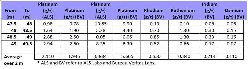
Table 3 – Assay results from Hole SX-MN21-18
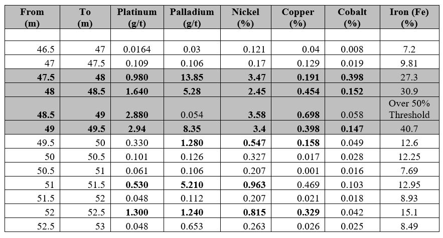
Table 4 – PGE assay results for 2m of Hole 18

This and previous work have provided evidence for the identification of a discovery referred to as the Bob Corridor carrying high-grade mineralization with dimensions of 270 meters in length in an east-west trend and at least 80 meters in depth based on drill intercepts. The mineralized zone is opened in all directions and at depth. (See Figures 10, 11 and 12)
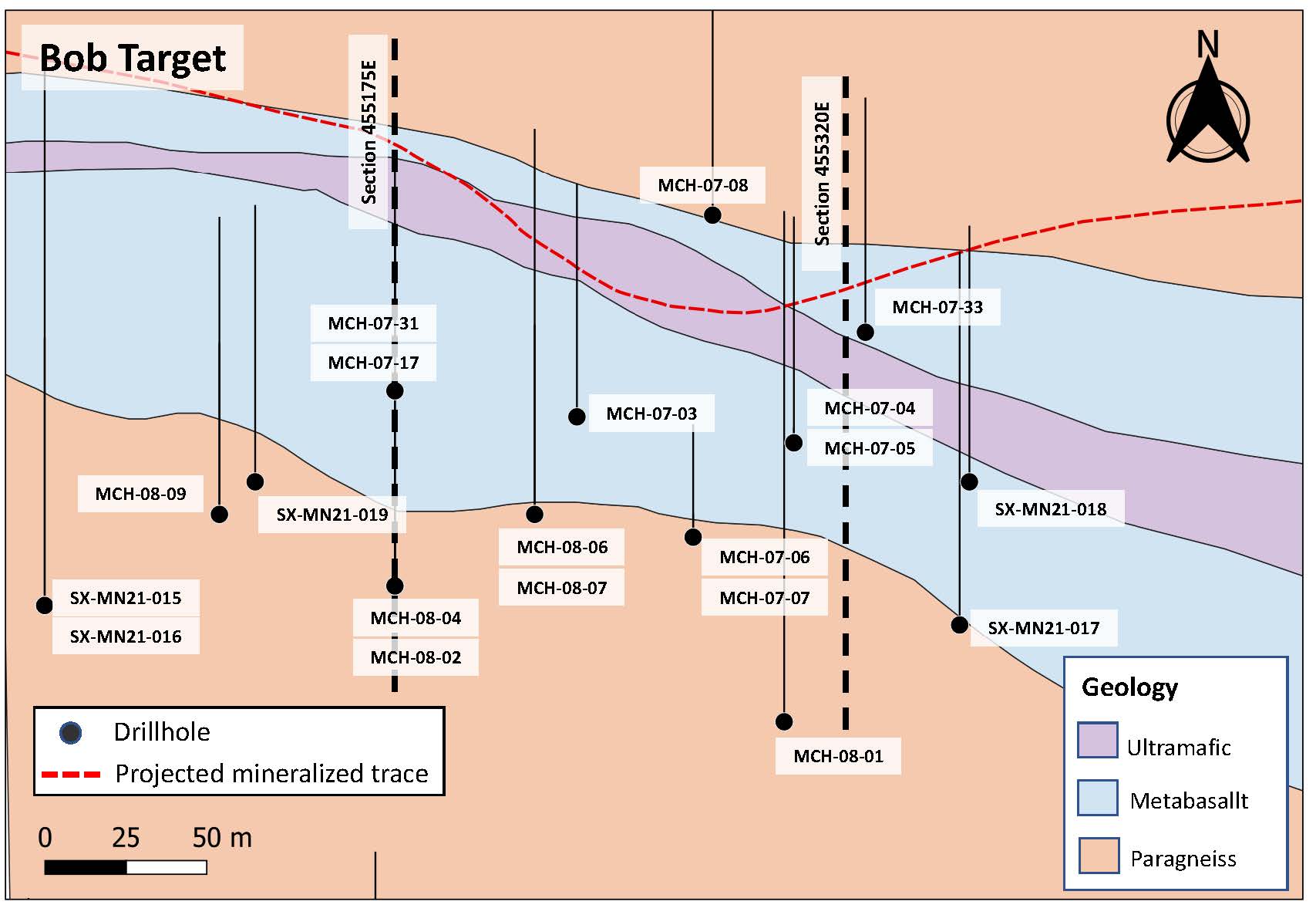
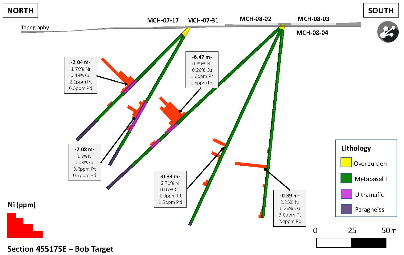

Table 6 – Complete summary of highlight assay results from the Manicouagan Project
| Hole ID | From (m) | To (m) | Width (meter) | Nickel% | Copper % | Cobalt % | Platinum g/t | Palladium g/t |
| 07-03 | 24.24 | 24.46 | 0.22 | 9.49 | 0.07 | 0.45 | 1.170 | 7.880 |
| 07-04 | 21.42 | 22.47 | 1.05 | 0.23 | 0.02 | 0.02 | 0.143 | 0.268 |
| And | 24.27 | 24.94 | 0.67 | 2.39 | 0.84 | 0.15 | 1.287 | 5.990 |
| 07-05 | 42.28 | 42.9 | 0.62 | 3.03 | 0.33 | 0.09 | 1.925 | 4.425 |
| 07-06 | 47.86 | 48.67 | 0.81 | 1.79 | 0.79 | 0.06 | 1.460 | 3.170 |
| 07-09 | 23.16 | 23.55 | 0.39 | 0.53 | 0.07 | 0.05 | 0.120 | 4.700 |
| 07-10 | 24.69 | 24.9 | 0.21 | 1.04 | 0.47 | 0.09 | 0.200 | 0.640 |
| 07-17 | 51.4 | 53.44 | 2.04 | 1.98 | 0.48 | 0.09 | 2.053 | 6.204 |
| 07-20 | 52.3 | 53.06 | 0.76 | 0.40 | 0.15 | 0.06 | 0.818 | 3.970 |
| 07-21 | 54.19 | 55.11 | 0.92 | 0.42 | 0.47 | 0.05 | 0.082 | 0.125 |
| 07-25 | 15.77 | 16.06 | 0.29 | 0.61 | 0.71 | 0.70 | <0.010 | 0.045 |
| 07-31 | 56.51 | 63.08 | 12.20 | 0.34 | 0.06 | 0.02 | 0.202 | 0.350 |
| Incl | 62.67 | 63.08 | 0.41 | 1.85 | 0.24 | 0.06 | 2.030 | 2.270 |
| 07-32 | 57.46 | 61.45 | 3.99 | 0.45 | 0.11 | 0.02 | 0.265 | 0.636 |
| Incl | 57.46 | 57.71 | 0.25 | 2.30 | 0.75 | 0.08 | 0.710 | 0.960 |
| Incl | 60.09 | 60.9 | 0.81 | 0.54 | 0.03 | 0.02 | 0.520 | 1.665 |
| 07-33 | 7.08 | 8.2 | 1.12 | 0.70 | 0.27 | 0.07 | 0.350 | 2.930 |
| 08-01 | 84.95 | 85.3 | 0.35 | 0.82 | 0.25 | 0.05 | 1.100 | 1.600 |
| 08-02 | 86.46 | 94.98 | 8.52 | 0.85 | 0.40 | 0.03 | 0.872 | 1.350 |
| Incl | 87.84 | 89.67 | 1.83 | 1.10 | 0.37 | 0.03 | 1.566 | 2.194 |
| 08-03 | 85.53 | 85.86 | 0.33 | 2.71 | 0.07 | 0.06 | 1.020 | 1.370 |
| And | 92.58 | 93.22 | 0.64 | 0.91 | 0.26 | 0.03 | 0.580 | 0.280 |
| 08-04 | 81.87 | 81.93 | 0.06 | 0.65 | 2.20 | 0.10 | 2.050 | 4.610 |
| And | 90.86 | 92.49 | 1.63 | 1.77 | 0.22 | 0.05 | 2.177 | 1.930 |
| 08-08 | 84.43 | 85.91 | 1.48 | 0.75 | 0.28 | 0.05 | 0.618 | 2.521 |
| And | 90 | 94.7 | 4.7 | 0.16 | 0.03 | 0.01 | 0.066 | 0.114 |
| 08-10 | 242.46 | 242.85 | 0.39 | 0.03 | 0.40 | 0.01 | <5 | <5 |
| 21-18 | 47 | 53 | 6 | 1.37 | 0.34 | 0.09 | 0.910 | 3.030 |
| Incl | 47.5 | 49.5 | 2.0 | 3.22 | 0.44 | 0.19 | 2.110 | 6.880 |
Table 7: Summary of low-grade nickel-cobalt-chromium intercepts from the Manicouagan Project
| Hole ID | From (m) | To (m) | Width (meter) | Nickel% | Cobalt % | Chromium % | Magnesium % |
| 07-02 | 30.13 | 50.00 | 29.87 | 0.13 | 0.007 | 0.13 | 12.5 |
| 07-08 | 8.00 | 14.50 | 6.50 | 0.17 | 0.01 | 0.28 | 15.7 |
| And | 52.00 | 88.00 | 36.00 | 0.16 | 0.01 | 0.22 | 15,8 |
| And | 94.80 | 99.00 | 4.20 * | 0.16 | 0.008 | 0.14 | 15.6 |
| 07-17 | 48.00 | 57.00 | 9.00 | 0.66 | 0.04 | NA | NA |
| 07-26 | 15.23 | 32.00 | 16.77 | 0.13 | 0.01 | 0.18 | NA |
| And | 36.00 | 41.00 | 5.00 | 0.15 | 0.009 | 0.14 | 15.5 |
| 07-31 | 55.61 | 68.00 | 12.39 | 0.28 | 0.008 | NA | NA |
| 07-32 | 60.09 | 68.00 | 7.91 | 0.23 | 0.01 | NA | NA |
| 08-01 | 112.60 | 125.72 | 12.12 | 0.14 | 0.009 | 0.17 | 13.6 |
| 08-02 | 82.66 | 100.92 | 18.26 | 0.60 | 0.02 | NA | NA |
| 08-07 | 81.70 | 95.10 | 15.40 | 0.17 | 0.009 | 0.20 | 16.6 |
| 08-08 | 82.35 | 86.40 | 4.05 | 0.50 | 0.04 | NA | NA |
| And | 90.00 | 95.41 | 5.41 | 0.15 | 0.01 | NA | NA |
| 08-10 | 235.00 | 240.00 | 5.00 | 0.18 | 0.01 | 0.30 | 16.5 |
| And | 244.00 | 288.00 | 44.00 | 0.17 | 0.009 | 0.17 | 17.1 |
| 21-02 | 52.00 | 60.00 | 8.00 | 0.10 | 0.009 | 0.12 | 11.8 |
| 21-11 | 84.00 | 120.00 | 36.00 | 0.10 | 0.01 | 0.14 | 14.2 |
| 21-17 | 61.00 | 68.00 | 7.00 | 0.18 | 0.01 | 0.10 | 8.0 |
| 21-18 | 46.00 | 53.00 | 7.00 | 1.18 | 0.08 | 0.17 | 7.3 |
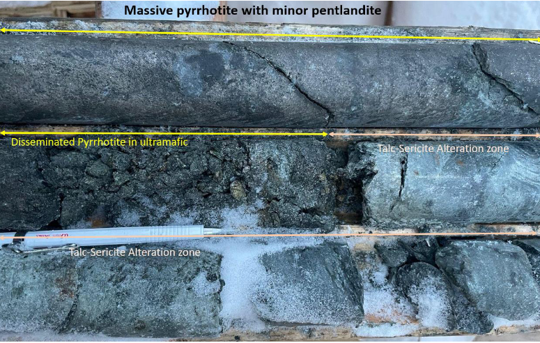
More importantly, the semi-massive to massive sulfide nature of the Bob mineralization suggests association with komatiites. The Electro-Magnetic (EM) anomalies are, in part, associated with these massive sulfide lenses which are highly deformed. Potential for a larger coherent body may exist within the Company’s large land holding.
Analysis shows that the mineralization is hosted in altered gabbro and ultramafic rocks consisting of massive to semi-massive to disseminated pyrrhotite, with nickel-copper-cobalt-platinum-palladium-rhodium mineralization. Arsenic is coincident with the PGEs and is believed to occur as gersdorffite and/or nickeline as the main nickel sulphide. Surrounding the sulphide- rich zones is a talc-sericite altered halo, which also contains disseminated mineralization.
Based on early logging and inspection of the cores from the first three holes, the Company’s geologists decided to retain the services of geophysicists to fly an airborne EM and magnetic survey that covered the entire claim block totaling roughly 3,360-line-kilometers.
The program’s first phase covered the active part of the Project at 25-meter spacing for 1,320 km-lines of High-Resolution EM and Mag survey. The second phase will target a larger area at 100m spacing. A second group of geophysicists was also contracted to conduct downhole geophysics in the most recent drill holes to test at depth and along strike. This work, coupled with the current drilling, will help vector in on the mineralized zones during the next phase, which was planned for the spring drilling campaign.
As noted above, prior to the completion of drilling, the company flew a detailed airborne magnetic survey over the entire land package and initiated downhole Electro-Magnetic (EM) surveys concentrated on the drill holes within the Bob mineralized zone. This survey identified additional targets within and to the south of known mineralization, suggesting the presence of a deep intrusive body. (See Figure 17)
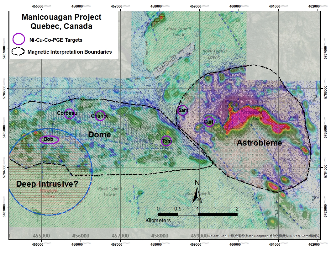
Upon completion of the close-spaced airborne magnetic survey, the Company’s contract geophysicist, Frank Fritz, was tasked with doing a full analysis on the property. During the assessment, Mr. Fritz identified unique features not previously defined (see Figure 17). The interpretation indicates a potential impact crater of an astrobleme on the eastern margin of the property. This feature is oval in shape and approximately 2.6 km by 3.5 km, as defined by its overall magnetic signature and the intense central magnetic feature.
Further to this interpretation, an elongated dome feature of the rocks immediately to the west is outlined by a second less dramatic magnetic response. This feature is approximately 5 km long by 2 km wide. The interpreted dome currently contains most of the nickel-copper-cobalt-PGE targets identified by the Company’s geologists and historically by others. Underlying and partially offset to the southwest of the dome, a possible deep intrusive is suggested as a source for the mineralized mafic rocks.
Given the Company’s geologic knowledge from past work, the geologic model for the Project has evolved. It is suspected that the astrobleme may be a fragment of the Manicouagan meteor. The trajectory calculated from the impact and doming was subvertical from east to west. The impact appears to have domed up the rocks to the west for over 5 km. Mineralization was injected either as part of the fragment or from depth within mafic and ultramafic sills or dikes, as identified in previous drilling. The inference of the dome is significant as it may mean that holes drilled in the past on the southern margin may have been oriented in the wrong direction, missing any near surface mineralization.
In mid-May 2023, the results from the 2022 fall drill campaign were announced with over limit assays reported just a few days later. Highlights of the Project include Hole MN22-03 hitting 9.4 meters averaging 1.11% nickel, 0.56% copper, 0.035% cobalt, 0.97 g/t platinum, 1.54 g/t palladium, 0.023 g/t gold starting at 5.6m from surface. See the complete list of drill intercepts from the drill campaign below.
Drill hole results and descriptions
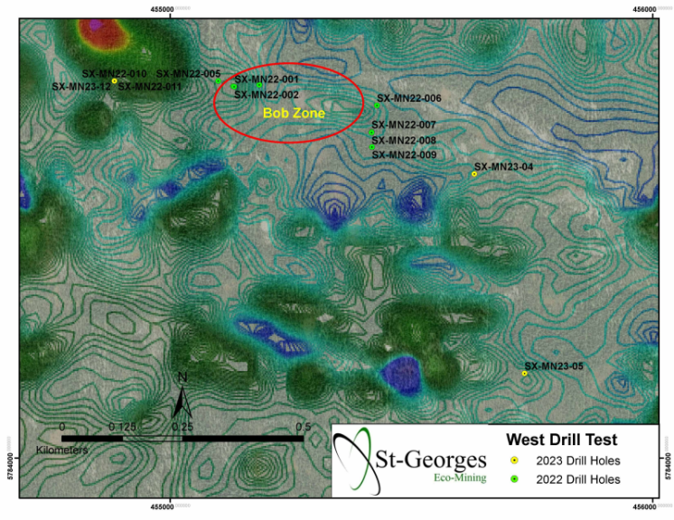
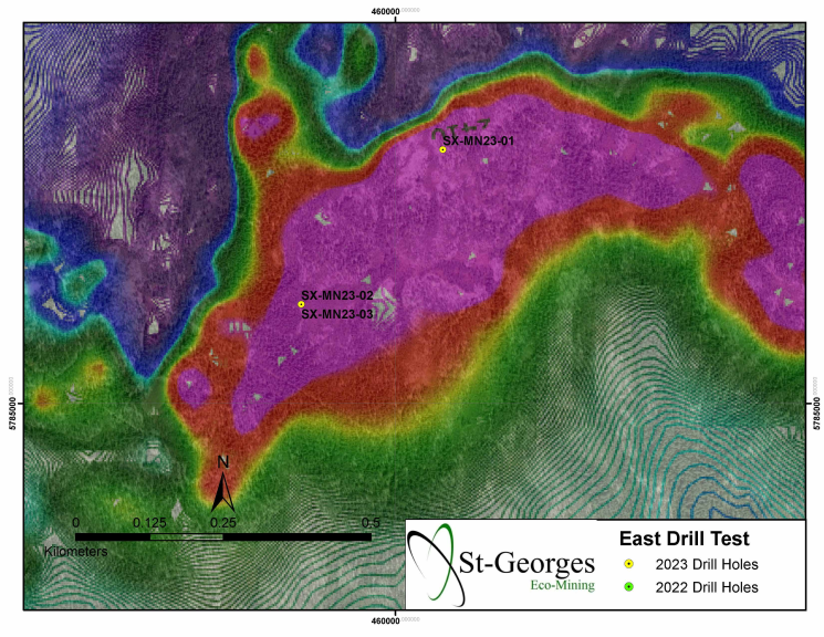
See Figures 13 & 14 for drill hole locations on maps.
The Bob Zone exploration drilling has confirmed high grades of nickel, copper, cobalt, and PGEs along an easterly trending fault zone traceable for up to 280 meters in length. The mineralization is hosted in altered gabbro (sericite-talc) and ultramafic rocks. The mineralization consists of massive pyrrhotite-nickel-copper-cobalt-platinum-palladium-rhodium-arsenic. This massive sulfide zone is mainly surrounded by a talc-sericite envelope which also hosts nickel, copper, cobalt, and PGEs without the iron content and is believed to be fed by a deep intrusive body to the south.
Additional work on the property will take advantage of the new EM and magnetic surveys and new understandings of the structure and surface geochemical targeting of arsenic. These advancements in understanding will provide vectoring in on further high grades of mineralization first identified in the Bob Zone. The Tom, Dernière Chance, and Sam areas stretch over a 5-kilometer corridor from the Bob Zone and have known mineralization at surface with multiple intercepts with similar grades and widths to Bob.
For more information on St-Georges Eco-Mining please visit https://stgeorgesecomining.com/
Information within this section of this document was sourced from
www.mrnfp.gouv.qc.ca/mines/index.jsp
https://sigeom.mines.gouv.qc.ca/signet/classes/I1108_afchCarteIntr
https://insidexploration.com/wp-content/uploads/2021/03/01-MCH2007-08-MRN-Report.pdf
https://www.stgeorgesecomining.com/
Disclosure
At the time of creation, St-Georges Eco-Mining is a client of Insidexploration Analytics Inc.
Disclaimer
Project Reports are under the Issuers editorial control and published on Insidexploration. Information contained in Project Reports may change over time and may differ from other sources. For more information, please reference https://stgeorgesecomining.com/ for Corporate, Technical Information and Project Specifications for the latest public disclosures.
Further;
The information herein is meant for informational and entertainment purposes only and does not constitute a recommendation to buy or sell securities. While every effort is taken to ensure the accuracy of everything contained on this website, no warranty of same is expressed or implied. While we endeavour to keep the information up to date and correct, we make no representations or warranties of any kind, express or implied, about the completeness, accuracy, reliability, suitability, or availability with respect to the website or the information, products, services, or related graphics contained on the website for any purpose. While every caution has been taken to provide readers with most accurate information, we recommend that you consult a registered investment professional in your jurisdiction before undertaking any investment in any asset whatsoever.