


Extended Research


Extended Research
- Trending
- Comments
- Latest

Delta Resources Limited (TSXV: DLTA) is a well financed Canadian mineral exploration company focused on growing shareholder value through the exploration of two very high-potential gold and base-metal projects in Canada. The two projects currently being advanced are the Delta 1 Gold Project in Thunder Bay, Ontario and the Delta 2 Gold/VMS Project outside of Chibougamau, Quebec. At this time, The Delta 1 project is the company’s primary focus after several successful drill campaigns in 2022,2023 and 2024, growing its gold inventory at the Eureka Gold Deposit.
Overview – General overview of the Delta 2 VMS/Gold Project
Regional Structural Features and Geology – Discussing the three (3) volcanic cycles of the Abitibi Volcanic Belt
Regional Deformation History – Highlighting the regional fault structures and rock packages.
Property-Scale Geology – Encompassing the various rock types on the property potentially responsible for the mineralization
Mineralization – Discussing the two types of mineralization prospects on the property
Exploration History – Detailed account of historic work done on the Delta 2 property.
Current Exploration Work – Detailed accounts of Delta’s exploration work
Conclusion – Closing statement.
The Delta-2 project is located roughly 35 kilometers southeast of the town of Chibougamau, Quebec, which provides most services necessary for mineral exploration. The property consists of 363 claims covering, 194 sq kilometers in the La Dauversière, Queylus, Dollier, Charron and Lemoine Townships. Access to the property is via paved highway 167 which crosses the western portion of the claim blocks along with a network of gravel roads and existing trails. A CN railway track crosses the western portion of the claim block along with provincial power lines to support any future operations.
This region is a very friendly mining jurisdiction with an abundance of infrastructure and manpower to support the mining industry. Historically, the Chibougamau area produced 1.6 billion pounds of copper and 1.2 million ounces of gold. Additionally, The Chapais mining camp has produced 1.1 billion pounds of copper, 800,000 ounces of gold and 8.2 million ounces of silver.

Delta owns a 100% interest in the 258 claims covering 205 sq kilometers. In addition, in 2021, the company also acquired the exclusive rights to earn a 100% interest in 40 contiguous claims covering an additional 22 sq kilometers from Cartier Resources.
The Delta-2 property has excellent potential for both gold-rich Volcanogenic Massive Sulphide (VMS) deposits and magmatic-hydrothermal gold deposits which are both highlighted in the Mineralization section below.
The Delta-2 property is located at the NE end of the Abitibi Volcanic Belt, which is part of the Caopatina-Desmaraisville segment that is delimited by the Kapunapotagen Fault to the north, the Guercheville Fault to the south, the Grenville Front to the east and the Lapparent massif to the west.
Volcanic Cycles
In the Chibougamau district, three (3) volcanic cycles are identified. All three consist generally of mafic volcanics (massive to pillowed) of tholeiitic affinity at their base, overlain by intermediate to felsic volcanics of transitional to calc-alkaline affinity.
Phase 1) The earliest evidence of deformation in the area consists of folds with axial traces trending NNW-SSE to NS. The relative age of this folding is unclear, but it appears to be pre-to syn-tectonic. It should also be noted that, except for the Henderson-Portage structure (045°/60°SE) most of the deposits in the Chibougamau Mining district are located on NW-SE-trending structures.
Phase 2a) Regional deformation is characterized by a strong EW-trending, generally steeply dipping foliation which is axial planar to isoclinal folds. Extensive EW-trending ductile shear zones also formed during this phase of deformation. These intense and often wide zones of deformation are believed to have formed with reverse movements. This phase of deformation is believed to be due to a NS compression.
Phase 2b) EW-trending structures are crosscut by sub-vertical, NE-SW-trending deformation zones with associated foliation. These structures formed initially with sinistral movements but have been reactivated during later phases of deformation. These structures are believed to have formed late during the second phase of deformation during NS-trending shortening.
Phase 3) Is characterized by a reactivation of the Phase 2b structures with a dextral sense of motion.
Phase 4) This last phase of deformation is characterized by NNE-SSW-trending faults with associated foliation but showing more brittle attributes. These structures are believed to have formed because of the Proterozoic collision of the Grenville Province and are more abundant in the eastern part of the region, at the Grenville Front. This phase of deformation would also have reactivated the Phase 2b structures with a dextral sense of motion.
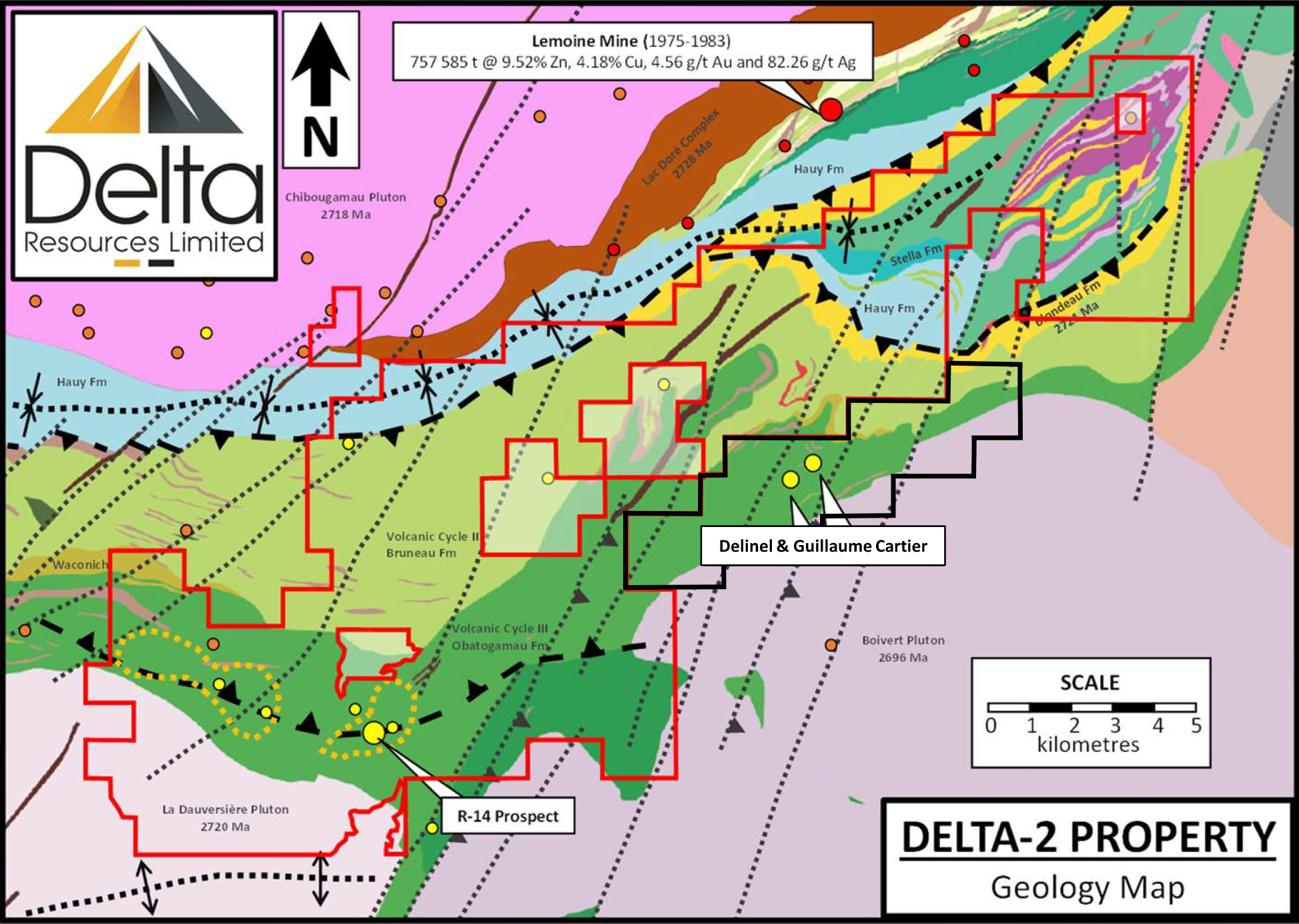
The Delta-2 property covers the north-eastern contact of the syn-volcanic La Dauversière pluton (2720 Ma). The La Dauversière pluton has a tonalitic composition and is thought to be responsible for many gold occurrences in the area such as the Chevrier Zone (43-101 Resource of 10.8Mt @ 1.22 g/t Indicated and 6.3Mt @ 1.27 g/t Au Inferred) and the R-14 Gold Prospect which is situated on the Delta-2 Property.
Immediately north of the La Dauversière Pluton, in the southern half of the property, rocks consist of massive to pillowed basalts of the Obatogamau Formation (Volcanic Cycle II). The basalts are intercalated with thin horizons of intermediate to felsic volcanics and presumably, are overlain by felsic volcanic rocks of the Waconichi Formation.
The northern half of the property is shown by the Quebec Ministry of Energy and Natural Resources as andesites and basalts of the Bruneau Formation (lower unit of Volcanic Cycle III). In the NE part of the property, the Bruneau Formation rocks are overlain by the felsic and sedimentary rocks of the Blondeau Formation (Upper part of Volcanic Cycle III).
In the Chibougamau area, the contact between Volcanic Cycles II and III is very prospective for Volcanogenic Massive Sulphide mineralization. In fact, the past producing Lemoine Mine (1975-1983: 757 585 tonnes @ 9.52% Zn, 4.18% Cu, 4.56 g/t Au and 82.26 g/t Ag), a small but very high grade, is located approximately two kilometres north of the property boundary, at that contact. A strike length of over 15-20 kilometres of this prospective contact is located on the Delta-2 property.
Stratigraphy is generally EW-trending and turns NE-SW in the eastern part of the property, generally wrapping around the more competent rocks of the La Dauversière and Boisvert plutons.
Extrusive rocks of the property are intruded by a few small syn-volcanic mafic sills and dikes and felsic dikes that are genetically linked to the La Dauversière Pluton (Faure, 2012) and spatially associated with the R-14 gold prospect.
Two types of mineralization are targeted by Delta on this property
The first of which are Volcanogenic Massive Sulphide (VMS) deposits, which are believed to be associated with the contact between Volcanic Cycle II and III. For context, Lemoine is an example, located approximately 2 kilometres to the north of the Delta-2 property boundary. The Lemoine mine produced 757 585 tons grading 9.52% Zn, 4.18% Cu, 4.56 g/t Au and 82.26 g/t Ag, placing it within the top 1% of all VMS worldwide in term of grade. The beauty of VMS deposits is that they generally form in clusters and given the proximity to Lemoine, just two kilometers to the north of Delta-2’s property, Delta holds very highly prospective ground.
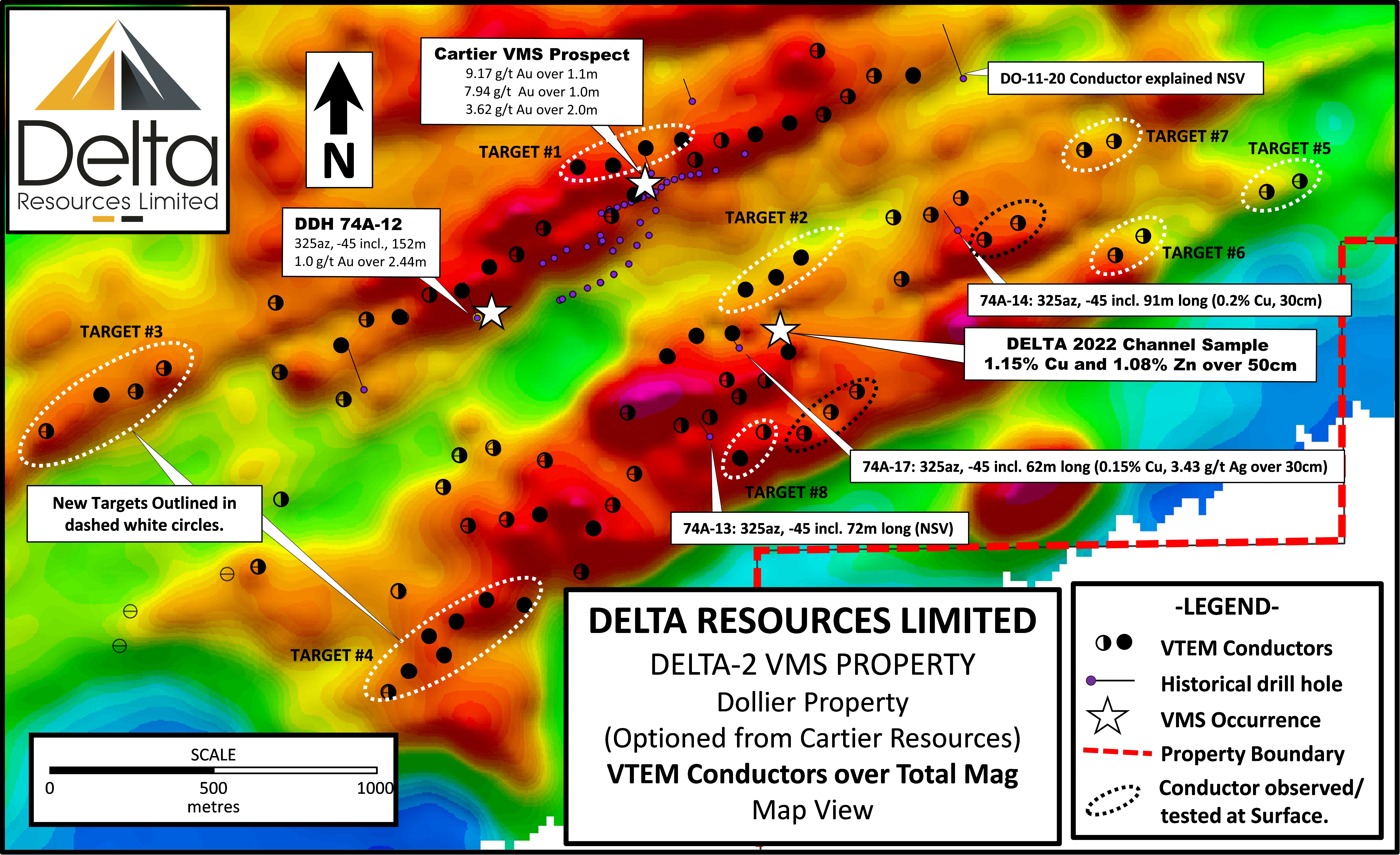
Additionally, at the Dollier Option, , are the Guillaume-Cartier and Delinel Gold prospects; two additional gold-rich occurrences showing volcanogenic massive sulphide affinity. Both prospects consist of gold-bearing, concordant lenses of disseminated to semi-massive pyrite-pyrrhotite with minor amounts of chalcopyrite and sphalerite. Drill hole intercepts of 27,52 g/t Au over 1 m; 4,77 g/t Au over 1 m; 1,04 % Cu over 1 m; 11,92 g/t Au over 1,0 m; 6,65 g/t Au, 7,3 g/t Ag et 1,0 % Cu over 0,3 m; 13,05 g/t Au over 1,2 m, are reported at Guillaume-Cartier.
The second type of mineralization being targeted on the Delta 2 project are Gold Hydrothermal systems or a typical greenstone belt gold intrusive deposit, like the past producing Joe Mann Mine which produced 1.17 Moz grading 8.26 g/t Au, 607 k oz of silver @ 5 g/t and 28.7 M lbs of copper @.25% Cu or the Chevrier deposit to the south west which holds an indicated and inferred resource of 680k oz Au grading 1.23 g/t and an inferred resource of 232k oz Au grading 1.62 g/t. There are plenty examples of these types of deposits throughout the Abitibi region that one could draw comparison to and Delta 2 could hold similar types of deposits.
The most important gold prospect at the Delta-2 Property consists of the R-14 Gold Prospect which is spatially associated with the Queylus deformation zone and a felsic dike swarm associated with the La Dauversière Pluton. At R-14, exceptional gold values of up to 142.29 g/t Au over core length of 2.44 metres have been intersected in the early 1980’s by Corner Bay Exploration (Brunelle, 1983 quoted by Faure, 2012). The property was later worked by D’Arianne Resources who also reported significant results in channel and drill samples.
Although the R-14 Gold Prospect is documented as hosted by the Queylus Deformation zone, Faure (2012) has documented a discordant alteration halo of over 3.5 x 1.1 kilometers surrounding the mineralized zone. A similar alteration zone of over 4×1 kilometers is also documented west of the R-14 gold prospect. The westernmost part of this alteration zone starts at the La Dauversière pluton contact.

Small scale exploration work has been carried-out since the 1950s on parts of what is now the Delta-2 property. Past exploration work consisted of prospecting, stripping, geophysical surveys and diamond drilling campaigns on small areas of the property. More focussed exploration was carried-out following the completion of an electromagnetic (EM) airborne survey (INPUT MK VI) flown by the Québec government in 1977. These government surveys prompted the staking of a number of small properties to test the anomalies by ground geophysics and eventually by drilling. This exploration work was carried-out between 1977 and the early 1980s and consisted of small ground EM surveys to better locate the anomalies in the field, followed by shallow drill holes (typically less than 100m in length). The great majority of this work was carried-out in the NE portion of what is now the Delta-2 property near the past producing Lemoine Mine (757 585 tons grading 9.52% Zn, 4.18% Cu, 4.56 g/t Au and 82.26 g/t Ag). Nevertheless, many large areas of the Delta-2 property remain unexplored.
By far, the largest historical exploration program at Delta-2 was carried-out at the R-14 Gold prospect in the southern portion of the property. The following section presents a short history of work completed on the R-14 prospect.
From 1975 to 1979, Rio Tinto Canadian Exploration Ltd. conducted geophysical surveys, prospecting and mechanical trenching work on 14 claims. Twenty-one (21) drill holes totalling 2,610 m were then completed to test the geophysical anomalies. Best results included:
From 1979 to 1987, Corner Bay Exploration Ltd. (Corner Bay) continued exploration at R-14 with ground geophysics, soil geochemical surveys and mechanical trenching. The company reported up to 129.08 g/t Au over 2.43 m from channel sampling.
In 1985, Corner Bay completed an additional 15 drill holes in the R-14 area, for a total of 2,558 m and best result included:
The property was dormant until 2004 when Arianne Resources inc. (Arianne) optioned the property from two (2) local prospectors. Between 2004 and 2014 the company carried-out prospecting, ground geophysical surveys and mechanical trenching. Ten (10) drill holes were then completed for a total of 1,482 m, leading to the discovery of new mineralized zones grading 0.97 g/t Au over 10.1 m and 2.04 g/t Au over 1.4 m, in drill holes R14-08-06 and R14-08-07 respectively.
In 2014, 2736-1179 Quebec inc. optioned the property and completed 10 drill holes totalling 1,562 m Best results include:
An additional 37 infill drill holes were completed the year after for a total of 5,858 m yielding no additional resource.
The property laid dormant until Delta’s option of the Delta-2 property and a very large land position spanning from the R-14 prospect to within 2km of the past producing Lemoine Mine.
Table of significant historical occurrences at the Delta-2 property.

2019 Exploration work
2020 Exploration work


2021 Exploration work
From January to March, 2021, Delta completed 18 drill holes for a total of 2,726.5 metres at the Delta-2 property. Drill holes 21 to 25 and 30/31 were aimed at VMS targets while drill holes 26 to 29 and 32 to 37 were aimed at gold targets.

Drilling of the gold targets culminated with the new Oli Gold discovery. Significant results are shown below:
During the summer of 2021, Delta completed a gravimetric survey covering a 4.5 square kilometer area. The objective of the survey was to outline large, buried sulphide masses which have a higher density than their host rocks. Three residual gravimetric anomalies of 0.6 mgal were detected at the core of a syncline affecting the favourable sulphide-bearing horizon. These targets will be drill tested in the fall of 2021 or early 2022.
Simultaneously, Delta completed a program of geological mapping, sampling, prospecting, and mechanical trenching. The program culminated in the discovery of the Lone Pine Gold Occurrence where grab samples returned 18.8 and 21.1 g/t Au (channel sampling results are pending). This geological mapping program also led to a better understanding of the structural controls and geometry of the gold mineralization. With structures trending 020 azimuth becoming gold targets as well as the structures trending at 060 azimuth.

During the months of November and December 2021, Delta completed sixteen (16) drill holes and deepened drill hole D2-21-27, for a total of 2709 metres. The drilling program was aimed at gold targets between the OLI and R-14 gold occurrences on two newly defined structures. The structures and some quartz-ankerite-tourmaline veins were intersected during the course of the program, in significant altered structures. All results from this program are still pending.
The drill program culminated in the discovery of the OLI Gold prospect that was announced on April 7th, Delta announced the results of the sixteen drill holes totaling 2,709 metres drilled in late 2021. The objective of the program was to test two (2) structures trending 060 azimuth, believed to host both the R14 gold prospect and Delta’s new OLI gold discovery. Every drill hole intersected anomalous gold values within strongly deformed and altered structures confirming the presence of a gold-bearing structure covering a minimum strike length of two (2) kilometres.

Table of Drill Results from 2021

2022 Exploration
On January 12th, Delta kicked off the year announcing a planned 36 hole campaign set out to test the up to 30 high-priority VTEM conductors showing geophysical signatures typical of VMS deposits in the area.
The 2022 drilling was completed at the Delta-2 VMS property in late May for a total of thirty (30) drill holes and a total of 6,551 metres. The drilling program tested three (3) gravity anomalies and twenty-seven (27) high-priority VTEM conductors.

In the course of this drill campaign, Delta encountered the sulphide horizon with four (4) areas/sections of interest:
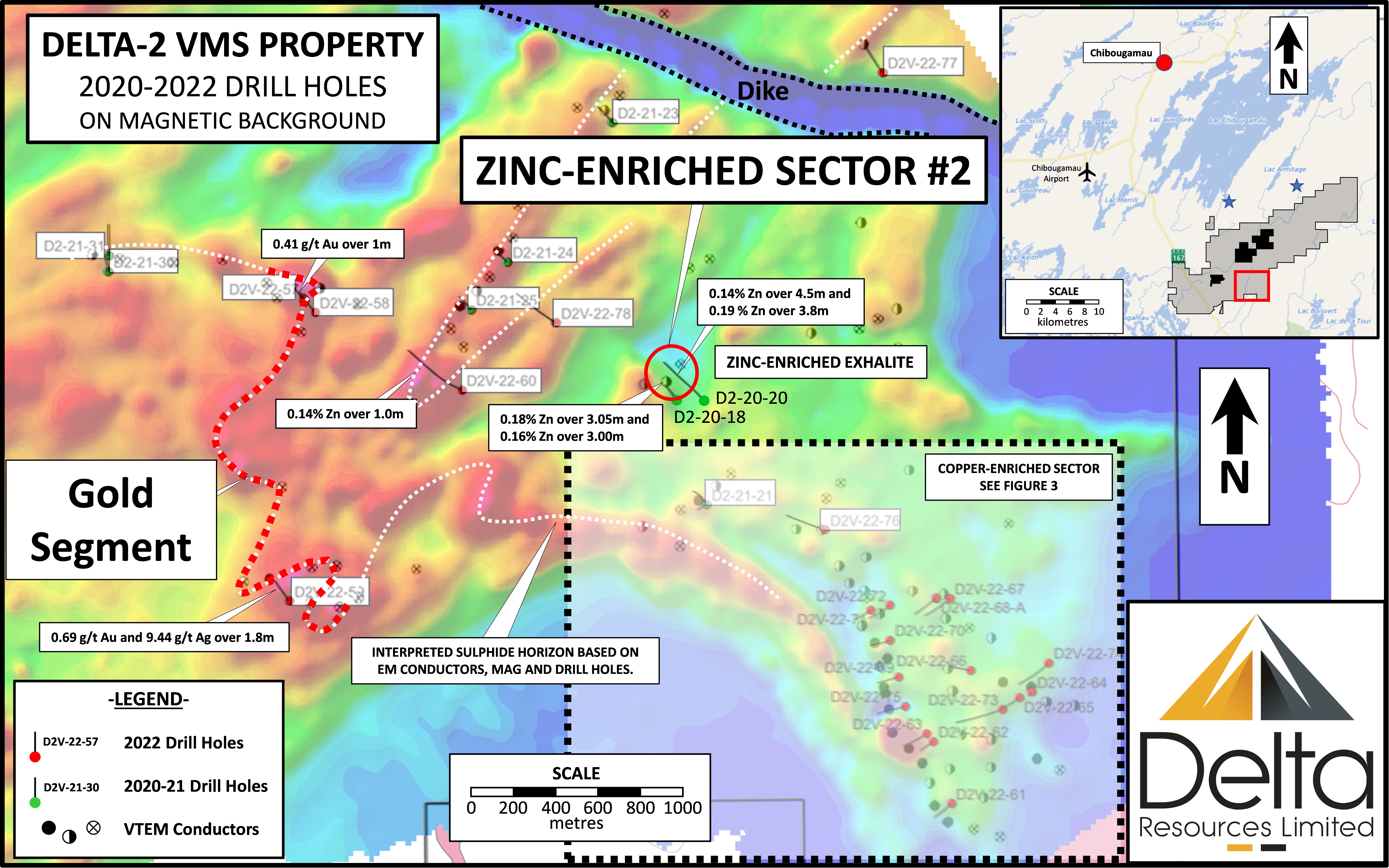


The drill holes intersected intensely altered mafic volcanics (see photo), rhyolites and rhyolitic volcaniclastites (garnet-sericite-chlorite). Sulphide conductors are typically associated with the felsic volcaniclastites and consist dominantly of pyrrhotite and pyrite with accessory chalcopyrite and sphalerite. Sulphide contents within the conductive zones vary from 5% to 100% and sulphide intercepts vary in thickness from 25cm to 15m.

The remaining results from the 2022 drill campaign were announced on August 30th See table
ADDITIONAL WORK CARRIED OUT AT THE DELTA-2 VMS in 2022
The program was highlighted by the discovery of a new massive to semi-massive lens located 615 metres south-east of the Cartier Gold occurrence (a gold-only volcanogenic massive sulphide lens discovered in 2012). Two initial grab samples returned 4.9% Zn and 0.3% Cu, and 1.25% Zn and 0.2% Cu. Follow-up channel sampling of the lens returned 1.12% Cu and 1.08% Zn over 50 centimetres. The discovery is in the vicinity of a new VTEM conductor defined over a minimum of 300 metres. (See Figure 13)
2023 Exploration
In late 2023, Delta completed seventeen (17) drill holes for a total of 3,752 metres. The exploration program was fully funded through Quebec-Flow-Through funds raised in late-2022. The drilling program was designed to test a number of helicopter-borne VTEM anomalies located on the Dollier-Cartier Option (Figure 13) which is contiguous to the Delta-2 property.
A massive to semi-massive sulphide horizon was intersected in drill holes D2V-23-96 and D2V-23-105, over a strike length of 100 metres. The horizon strikes NE, dips steeply towards the SE and is located approximately 600 metres SE of the Guillaume-Cartier Gold-VMS prospect (see figure 14). The horizon is open to the SW and at depth and for approximately 400 metres to the NE.

Mineralization in drill holes D2V-23-96 and D2V-23-105 consists of pyrite, pyrrhotite, sphalerite and trace chalcopyrite. Host rocks are mafic volcanics, altered to chlorite-sericite. Every other drill hole of the program intersected sulphide mineralization of dominantly pyrite and pyrrhotite with trace of sphalerite and chalcopyrite. All drill results are shown in Table 1 below.

The Delta 2 Project is a highly prospective exploration property in close proximity to the Lemoine mine and warrants additional follow up work based on the aforementioned exploration conducted on the property. However, at this time the company’s main focus is the Delta-1 gold project in Thunder Bay, Ontario which has been a huge success story as drilling continues to highlight a large alteration zone containing high grade gold.
Updates will be made as they occur
Disclosure
At the time of creation, Delta Resources is a client of Insidexploration Analytics Inc.
Disclaimer
Project Reports are under the Issuers editorial control and published on Insidexploration. Information contained in Project Reports may change over time and may differ from other sources. For more information, please reference www.deltaresources.ca for Corporate, Technical Information and Project Specifications for the latest public disclosures.
Further;
The information herein is meant for informational and entertainment purposes only and does not constitute a recommendation to buy or sell securities. While every effort is taken to ensure the accuracy of everything contained on this website, no warranty of same is expressed or implied. While we endeavor to keep the information up to date and correct, we make no representations or warranties of any kind, express or implied, about the completeness, accuracy, reliability, suitability or availability with respect to the website or the information, products, services, or related graphics contained on the website for any purpose. While every caution has been taken to provide readers with most accurate information, we recommend that you consult a registered investment professional in your jurisdiction before undertaking any investment in any asset whatsoever.
All Issuer content within this space is considered authored by the Company as an extension of their digital presence. All copyrights are retained by each respective creator(s).